The University of Tulsa
Mountain Cedar Pollen Forecast
Metropolitan Area |
Exposure Risk |
|
Dallas/Fort Worth |
Moderate |
|
Austin |
Severe |
|
San Antonio |
Low |
Date Issued: 2 January 2006
Mountain Cedar Location(s): Edwards Plateau, Texas
Regional Weather: Mon.
and Tue., Jan 02 and Jan 03. TX/OK: The
Texas/Oklahoma area will continue to be warm and dry today and tomorrow with high pressure building to the south
and west. There is no foreseeable chance of precipitation throughout the region. A strong low pressure system will
continue to move just south of the Great Lakes region continuing to pull the trajectories to the north and northeast.
Winds start today from the west shifting towards a more south to north direction overnight and for tomorrow. This
low pressure will continue to fuel strong winds across the region further complicating current efforts to control
wild fires. Todays temperatures will be cooler with highs in the low 60s across Oklahoma and the upper 60s to
low 70s in Texas. Humidity will remain low during the day with values in the 10-20% range in west rising towards
the east and north, but remaining below 40% region wide. Tomorrow, temperatures throughout the region will become
warmer with highs in Oklahoma reaching the 70s and Texas showing highs in the upper 70s to low 80s. Nighttime temperatures
will remain above average for this time of year, in the upper 30s to low 40s in the north and low to mid 40s to
the south.
Trajectory weather: The air mass trajectories from the Edwards
Plateau Texas move to the northeast today backed by strong westerly winds. The trajectories to the west are associated
with a sinking atmospheric conditions that are poor for entrainment and travel., whereas to the east atmospheric
conditions appear to be rising. Warm temperatures, low relative humidity and strong winds throughout the Edwards
Plateau will be good for pollen dispersal. High nighttime humidity, especially to the east, will aid the ripening
of the cones making pollen release potential even greater. Movement of pollen entrained should be reduced towards
the west because of the poorer atmospheric conditions, whereas those towards the east may provide greater long-distance
dispersal potential.
OUTLOOK: *** Severe threat to the east, Moderate
threat to the west*** Temperatures,
humidity are optimal for pollen release on the Edwards Plateau, the severe drought throughout the region has delayed
the pollen season but high atmospheric counts in Austin indicate that cones are ripening and dispersing their pollen
load. Strong winds will bring high concentrations from the east of the Edwards Plateau towards northeastern Texas
and southeastern Oklahoma. The Dallas/Fort Worth region may be affected, but near ground level wind movement should
filter out much of the pollen. The Austin area, which borders the main Juniperus ashei pollen may see significant
amounts.
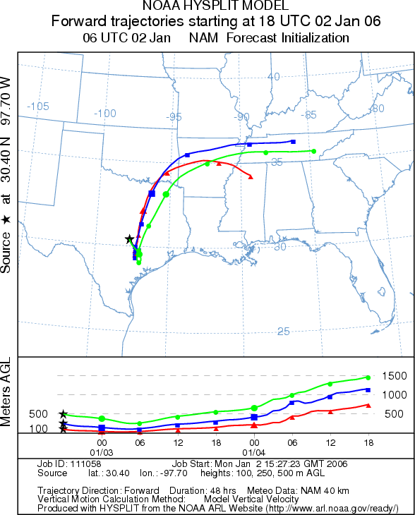
Trajectory Start (s) (shown by *
on map): Austin, TX; Junction, TX; San Angelo, TX.
AUSTIN
JUNCTION

SAN ANGELO
Prepared by: Estelle
Levetin (Faculty of Biological
Science, The University
of Tulsa, 600 S. College, Tulsa, OK 74104) in conjunction with Peter K Van de Water. This forecast
gives the anticipated future track of released Mountain Cedar pollen, weather conditions over the region and along
the forecast pathway, and an estimated time of arrival for various metropolitan areas.
Questions: Aerobiology Lab e-mail: pollen@utulsa.edu
Return to Forecasting Home Page