The University of Tulsa
Mountain Cedar Pollen Forecast
Metropolitan Area |
Exposure Risk |
|
Dallas/Fort Worth |
Low |
|
Austin |
Moderate |
|
San Antonio |
Severe |
Date Issued: 4 January 2006
Mountain Cedar Location(s): Edwards Plateau, Texas
Regional Weather: Wed.
and Thurs., Jan 04 and Jan 05. TX/OK: The
Texas/Oklahoma area will continue to warm and be dry today and tomorrow with high pressure building to the west.
There is no foreseeable chance of precipitation throughout the region, and the dip in temperatures yesterday are
expected to build back up today and tomorrow. Winds across the region will decrease a bit today but return to gusty
conditions tomorrow. A building high pressure zone over the central Rockies will cause wind directions to switch
to a southerly direction both today and tomorrow. High winds and continued low humidity, 10 to 20% in most areas
rising to about 40% in northern Oklahoma, will exacerbate the current efforts to control wild fires. A red flag
warning for fire danger is posted for an area from central Texas northward across eastern Oklahoma. To the north,
in Oklahoma, temperatures will be in the upper 50s to low 60s today. Overnight temperatures will remain above freezing
but in the thirties. Temperatures will remain in the same range tomorrow. In Texas highs today will reach into
the 60s to low 70s across the region. Nighttime temperatures will remain above freezing in the low to mid 40s.
Tomorrows highs will be about the same. Humidity will remain low during the day with values in the 20 - 30% across
the region.
Trajectory weather: The air mass trajectories from the Edwards
Plateau Texas move to the South backed by strong winds from a building High pressure zone over the central Rocky
Mountains. The trajectories to the west are associated with a sinking atmospheric conditions that are poor for
entrainment and travel., whereas to the east atmospheric conditions begin stable then show rising characteristics.
Temperatures will be warm with many locations reaching into the upper 60s to low 70s today and tomorrow. Low relative
humidity, less than 30% and strong winds throughout the Edwards Plateau will be good for pollen release and dispersal.
Very high pollen counts were recorded yesterday in Austin suggesting that pollination is in full swing. Movement
of entrained pollen should be reduced towards the west because of the poorer atmospheric conditions, whereas those
towards the east may provide greater long-distance dispersal potential.
OUTLOOK: *** Severe to Low threat***
Temperatures and humidity are optimal for pollen release
on the Edwards Plateau, the severe drought throughout the region has delayed the pollen season but very high atmospheric
counts in Austin indicate that cones are ripening and dispersing their pollen load. Strong winds will bring severe
concentrations from the central and eastern areas of the Edwards Plateau into San Antonio and other regions along
the southern edge of the Edwards Plateau. Greater, near ground level wind movement on the eastern Edwards Plateau
should filter out much of the pollen, therefore concentrations may not be extremely high. The Austin area extending
north towards Waco, which borders the main Juniperus ashei population, will see moderate pollen concentrations
within the atmosphere. Whereas they are very close to the pollinating populations a southerly wind direction should
move wind trajectories from the north, areas without significant populations over each urban area. The southerly
wind direction will be maintained overnight into tomorrow, therefore affected areas should continue to be on guard
for heightened atmospheric concentrations.
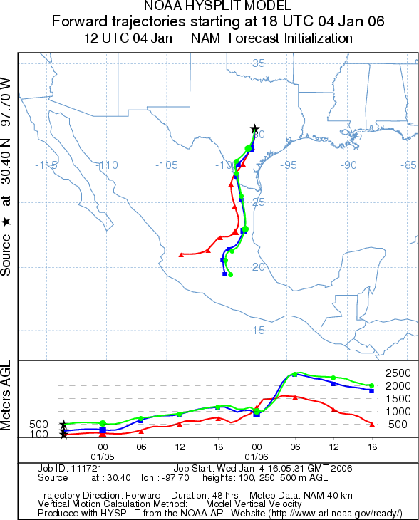
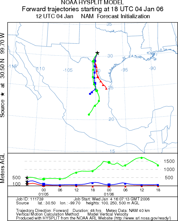
Trajectory Start (s) (shown by *
on map): Austin, TX; Junction, TX; San Angelo, TX.
AUSTIN
JUNCTION
SAN ANGELO
Prepared by: Estelle
Levetin (Faculty of Biological
Science, The University
of Tulsa, 600 S. College, Tulsa, OK 74104) in conjunction with Peter K Van de Water. This forecast
gives the anticipated future track of released Mountain Cedar pollen, weather conditions over the region and along
the forecast pathway, and an estimated time of arrival for various metropolitan areas.
Questions: Aerobiology Lab e-mail: pollen@utulsa.edu
Return to Forecasting Home Page