The University of Tulsa
Mountain Cedar Pollen Forecast
Metropolitan Area |
Exposure Risk |
|
Oklahoma City |
Low |
|
Tulsa |
Low |
|
St. Louis MO |
Low |
Date Issued: 5 Jan 06
Mountain Cedar Location(s): Arbuckle Mountains, OK
Regional Weather: Thurs.
and Fri., Jan 05 and Jan 06. TX/OK: The
Texas/Oklahoma area will continue to warm and be dry today and tomorrow with high pressure building to the west
and to the south. There is no foreseeable chance of precipitation throughout the region, the dip in temperatures
yesterday are expected to even out today and tomorrow in the low 60s to the north and the mid 60s to the south.
The high pressure to the west will funnel cooler air across the northern region resulting in low temperatures
near freezing in northern Oklahoma Winds across the region will be gusty today then relax tomorrow region wide.
A building high pressure zone over the central Rockies will maintain the current north to south wind directions
both today and tomorrow. High winds and continued low humidity, ~20% in most areas rising to about 40% in northern
Oklahoma, will exacerbate the current efforts to control wild fires. A red flag warning for fire danger is posted
for an area from central Texas eastward with warnings posted in Oklahoma.
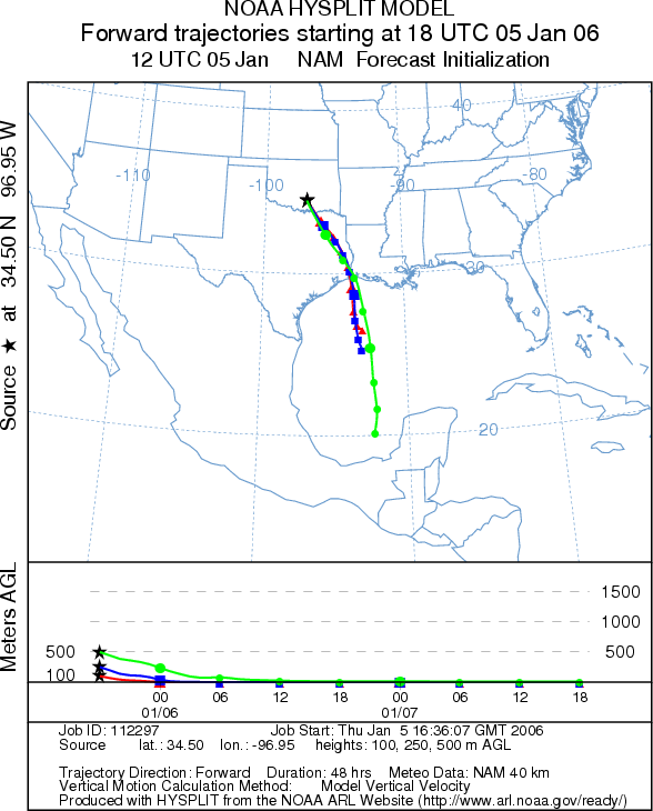
Trajectory weather: The air mass trajectories move from
the Arbuckle Mountains to the south over eastern Texas towards the Gulf Coast border with Louisiana. The trajectories
are associated with sinking atmospheric conditions that are characteristically poor for pollen entrainment and
travel. However, warm daytime temperatures, clear skies and low relative humidity are excellent conditions for
pollen release.
OUTLOOK: *** Low threat *** Conditions are
very good for pollen release today and tomorrow. At this time increased levels of atmospheric pollen to the south
along the eastern edge of the Edwards Plateau indicates pollination is occurring throughout the region. Atmospheric
conditions are poor for entrainment and travel as they are characterized by sinking air. Pollen entrained and
moving so close to the ground is more susceptible to impaction on other vegetation resulting in low downwind concentrations.
Therefore there is a low threat to downwind communities. The southerly wind direction excludes any potential
impact to Oklahoma City, Tulsa or beyond the region. In addition the eastward movement of pollen should exclude
any significant impact to Dallas/Fort Worth or the longer travel distances to the Houston metropolitan area.
Trajectory Start (s) (shown by black
star on map): Sulfur, OK.
Prepared by: Estelle
Levetin (Faculty of Biological
Science, The University
of Tulsa, 600 S. College, Tulsa, OK 74104) in conjunction with Peter K Van de Water. This forecast
gives the anticipated future track of released Mountain Cedar pollen, weather conditions over the region and along
the forecast pathway, and an estimated time of arrival for various metropolitan areas.
Questions: Aerobiology Lab e-mail: pollen@utulsa.edu
Return to Forecasting Home Page