The University of Tulsa
Mountain Cedar Pollen Forecast
Metropolitan Area |
Exposure Risk |
|
Dallas/Fort Worth |
Low to Moderate |
|
Austin |
Low to Moderate |
|
San Antonio |
Low to Moderate |
Date Issued: 3 January 2008
Mountain Cedar Location(s): Edwards Plateau, Texas
Regional Weather: Thursday, January 3 TX/OK: The
weather today and tomorrow will be relatively mild but is coming off of a very cold night, thus it will take some
time to warm up. Cloudy skies across Oklahoma today will begin to decrease, however along the Texas border to
the south this morning will see periods of freezing rain and sleet. Conditions in Oklahoma will be cool today
with temperatures across Oklahoma to get into the mid 40s. Winds across the region will be strong and from the
south at 15 to 20 mph during the day and overnight. Skies will be mostly cloudy overnight with temperatures hovering
around the freezing mark. Tomorrow during the day and into tomorrow night skies will remain partly cloudy but
temperatures will rise into the mid to lower 50s and will stay relatively steady over Friday night into Saturday.
Winds will remain moderate to strong, 15 to 20 mph from the south, tomorrow into Saturday. In Texas, temperatures
today will be in the lower to mid 50s across the Edwards Plateau and in the surrounding communities. Areas on
the Plateau have up to a 20% chance of precipitation this morning. Winds across central Texas will be moderate
to strong, 10/20 to 25/30 mph on the Edwards Plateau decreasing to 10/15 along the Plateau edge. Winds will be
from the south to southeast region wide. Overnight the skies will be partly to mostly cloudy with fog developing
overnight. Temperatures will be in the mid to upper 30s and low 40s over the region. Winds will remain moderate
to strong and from the south. Friday will be partly cloudy over the Plateau and along the edge communities from
Austin to San Antonio with fog in the morning. Temperatures will warmer with highs in the upper 50s and lower
to mid 60s across the Edwards Plateau and along the eastern and southern edge communities. Winds will remain moderate
to strong from the south. Low temperatures overnight on Friday will be warmer with many areas in the mid 40s to
lower 50s.
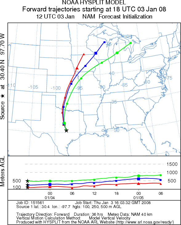
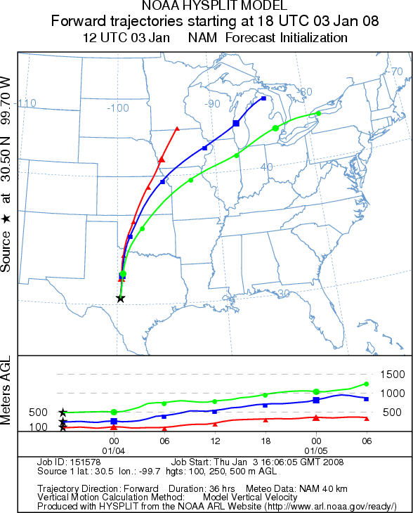
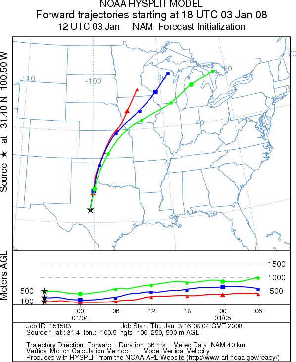
Trajectory weather: The air mass trajectories move from the Edwards Plateau travel due north across central
Oklahoma, onto Kansas, Nebraska and Iowa towards the upper mid-west. Cloudy skies and cool temperatures over the
Edwards Plateau Juniperus ashei population create poor to moderate conditions for pollen release. Wind characteristics
show relatively stable atmospheric conditions suggesting poor characteristics for entrainment of any pollen that
is released. Weather conditions make for a forecast of poor pollen release and entrainment from the Arbuckle Mountains
and poor to moderate from the Edwards Plateau population today with some improvement tomorrow.
OUTLOOK: *** Low to moderate threat today; Poor to fair conditions
for pollen release *** Cool temperatures will be warming to the mid to low
50s in the afternoon limiting any pollen release to the afternoon. In Texas, conditions are moderate to poor for
pollen release today with conditions potentially improving tomorrow. The trajectories show movement directly north
across Oklahoma, onto Kansas, Nebraska and Iowa then on to the upper mid-west. The trajectory characteristics
show the atmosphere to be stable to sinking conditions that are not particularly conducive to pollen entrainment
and long-distance travel over long time periods. If any pollen is released it would directly impact the areas
directly north of the Edwards Plateau, therefore the Dallas area is under a moderate threat. Pollen collection
in the communities of Waco, Austin and San Antonio indicate the trees are in their main period of pollination;
therefore, the potential for some pollen is present in the area.
Trajectory Start (s) (shown by *
on map): Austin, TX; Junction, TX; San Angelo, TX.
AUSTIN
JUNCTION
SAN ANGELO
EDWARDS PLATEAU COMPOSITE
Prepared by: Estelle
Levetin (Faculty of Biological
Science, The University
of Tulsa, 600 S. College, Tulsa, OK 74104) and ) and Peter K Van de Water (Department of Earth and
Environmental Science, California State University Fresno, 2576 East San Ramon Avenue, M/S ST24, Fresno CA 93740-8039).
This forecast gives the anticipated future track of released Mountain Cedar pollen, weather conditions over the
region and along the forecast pathway, and an estimated time of arrival for various metropolitan areas.
Questions: Aerobiology Lab e-mail: pollen@utulsa.edu
Return to Forecasting Home Page