The University of Tulsa
Mountain Cedar Pollen Forecast
Metropolitan Area |
Exposure Risk |
|
Dallas/Fort Worth |
High |
|
Austin |
High |
|
San Antonio |
High |
Date Issued: 7 January 2008
Mountain Cedar Location(s): Edwards Plateau, Texas
Regional Weather: Monday, January 7 TX/OK: The
weather today and tomorrow will be influenced by the movement of systems out of the western Rocky Mountains. Skies
across Oklahoma this morning will begin to become cloudier later in the day and into the nighttime hours. The cloudy
skies results in a 20 to 40% chance of showers this morning from Oklahoma City south towards the Texas border.
Temperatures in Oklahoma will be similar to yesterdays with highs in central Oklahoma in the lower 70s climbing
to the mid-70s in southern Oklahoma. Winds across the region will be from the south 15 to 20 mph during the day.
Overnight winds will start to turn heading out of the southwest. Overnight, temperatures will be in the upper 30s
to lower 40s with an increasing chance of precipitation from north to south. Tomorrow during the day and into tomorrow
night skies will begin to clear with a 15 to 20 degree drop in daytime temperatures. Winds will remain moderate
switching to the southwest to west towards tomorrow evening. Overnight temperatures will also drop by about 10
degrees, reaching the upper 20s to mid 30s from north to south. In Texas, temperatures today will remain warm,
in the lower to mid 70s across the Edwards Plateau and in the upper 70s in the communities surrounding the Edwards
Plateau. Winds across central Texas will be from the southwest, light to moderate, 5/15 mph on the Edwards Plateau
increasing to 10/20 from the southeast along the Plateau edge. Overnight the skies will be partly cloudy with a
slight chance of rain along the eastern edge communities. Temperatures will remain warm with lows expected in the
low 60s to mid 50s. Tuesday will be clearing over the Plateau and along the edge communities from Austin to San
Antonio. Temperatures will drop by 5 to 10 degrees across the Edwards Plateau and along the eastern and southern
edge communities. Winds will remain steady switching from the south - southeast to the west - northwest. Low temperatures
overnight on Tuesday will be colder with many areas in the mid 30s to mid 40s.
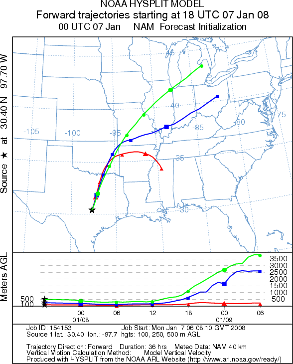
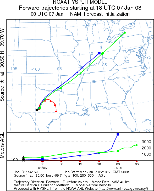
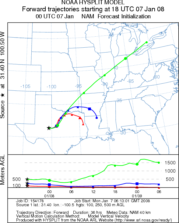
Trajectory weather: The air mass trajectories move from the Edwards Plateau northeast across the southeastern
corner of Oklahoma, into Arkansas before turning towards the south into Louisiana and eastern Texas. Populations
in the Arbuckle Mountains will be influenced by increasing clouds and heightened chances of precipitation this
afternoon. However, temperatures will remain warm, but with high humidity. The trajectories move north northeastward
over Oklahoma into northern Missouri and into Illinois. Partly to mostly cloudy skies, high humidity and increasing
chances of precipitation along the eastern edge of the Edwards Plateau create moderate to favorable conditions
for pollen release, especially to the west where humidity will be lower. Wind characteristics show stable to sinking
atmospheric conditions suggesting poor to moderate characteristics for entrainment of any pollen that is released.
However, wind strength will be somewhat lower than the past few days. Weather conditions make for a forecast of
moderate to good pollen release and poor to moderate entrainment from the Edwards Plateau population today with
some improvement tomorrow.
OUTLOOK: *** Moderate to High threat today; Moderate to Favorable pollen release conditions on the Edwards Plateau, Poor to Moderate entrainment conditions on the Edwards Plateau***
Temperatures will be warm today, but skies will be partly cloudy this morning with increasing clouds this afternoon
and an increasing chance of precipitation this afternoon along the eastern edge of the Edwards Plateau and its
Juniperus ashei populations. Overall, moderate to favorable pollen release conditions are expected, only poor to
moderate entrainment conditions will exist across the Edwards Plateau today. Light to moderate winds will carry
any entrained pollen northeast into Arkansas before turning southward. Pollen collection in the communities of
Waco, Austin and San Antonio indicate high concentrations of pollen in the atmosphere thus the trees are in their
main period of pollination. With the warm temperatures and the stage of release that the Edwards Plateau trees
are in (middle of the pollination period) significant amounts of pollen may be available for entrainment, even
though the conditions for long-distance travel are not particularly good. Therefore high threats exist for the
nearest urban communities of Dallas, Waco, Austin and San Antonio. However, exposure risk for more distant communities
will drop significantly with distance for the Juniperus ashei populations.
Trajectory Start (s) (shown by *
on map): Austin, TX; Junction, TX; San Angelo, TX.
AUSTIN
JUNCTION
SAN ANGELO
EDWARDS PLATEAU COMPOSITE
Prepared by: Estelle
Levetin (Faculty of Biological
Science, The University
of Tulsa, 600 S. College, Tulsa, OK 74104) and ) and Peter K Van de Water (Department of Earth and
Environmental Science, California State University Fresno, 2576 East San Ramon Avenue, M/S ST24, Fresno CA 93740-8039).
This forecast gives the anticipated future track of released Mountain Cedar pollen, weather conditions over the
region and along the forecast pathway, and an estimated time of arrival for various metropolitan areas.
Questions: Aerobiology Lab e-mail: pollen@utulsa.edu
Return to Forecasting Home Page