The University of Tulsa
Mountain Cedar Pollen Forecast
Metropolitan Area |
Exposure Risk |
|
Dallas/Fort Worth |
Low |
|
Austin |
Low to Moderate |
|
San Antonio |
Low to Moderate |
Date Issued: 22 January 2008
Mountain Cedar Location(s): Edwards Plateau, Texas
Regional Weather: Tuesday, January 22nd TX/OK:
The weather today and tomorrow will be cold to the north and cool southward as systems move through the region
influenced by the overall cold chill that is gripping the central portion of the United States. The region will
experience cold temperatures throughout Oklahoma with high temperatures in the low to mid 30s today with mostly
sunny skies north and partly cloudy skies southward. Winds will be moderate, 10 to 15 mph, from the north during
the day becoming light and variable tonight. Overnight temperatures will be in the upper teens. High temperatures
tomorrow will be slightly warmer but still below the 40s. Winds will be from the west at light to moderate levels
(~10 mph). Skies will be partly cloudy increasing to mostly cloudy overnight on Wednesday. Low temperatures Wednesday
night will return to the upper 10s with winds from the north remaining at moderate levels. In Texas, high temperatures
today will increase from northwest to southeast central Texas, reaching from the middle 40s to middle 50s. Temperatures
will begin to drop during the early afternoon into the mid 40s to upper 30s. In the surrounding edge communities
temperatures will remain mild, in the mid to upper 60s. Today, skies will be Cloudy with a 20% chance of precipitation
late this afternoon and tonight. Winds across Texas will be from the northern quadrant and will be light to moderate
across the Edwards Plateau (5 to 15 mph) and moderate to strong (15 to 20 mph) along the edge communities. Overnight
skies will continue to be cloudy with moderate winds from the north to northeast on the Plateau and the surrounding
edge communities. Tomorrows temperatures will remain cool with the Edwards Plateau in the mid 40's and the surrounding
communities in the low 50s. Skies will remain mostly cloudy with a 20% chance of precipitation across the region
during the day with increasing chance of rain along the edge communities overnight. Winds will remain light to
moderate from the north to northeast.
Trajectory weather: Conditions today and tomorrow will degrade towards a front moving in on Wednesday.
In the Arbuckle Mountains, northern winds will move trajectories due south on light to moderate winds from the
northern quadrant today and tomorrow. Cold temperatures, remaining below 40 degrees will occur throughout Oklahoma
today and tomorrow. Skies will be clear towards the north today with mostly sunny conditions over Oklahoma City.
Overnight today and tomorrow, mostly cloudy skies will occur throughout the region. In Texas, temperatures on
the Edwards Plateau will be cool with highs today occurring early with a 5 to 10 degree cooling after noon. Tomorrow,
temperatures will remain at cooler levels. In the edge communities, temperatures in the low to upper 60's will
cool tomorrow into the lower 50s. Lows across the region will be in the mid 30s tonight and tomorrow night. There
is an increasing chance of precipitation tonight and into tomorrow The air mass trajectories move from the Edwards
Plateau southward on northern winds which will then turn across western Texas and back over the Edwards Plateau.
Wind characteristics today are relatively cold and heavy which is poor for entrainment and travel but with more
buoyant conditions tomorrow as a cold front moves through. Cold temperatures today and an increasing chance of
precipitation to the south in Texas suggest poor conditions for release and for entrainment of pollen from the
Oklahoma Juniperus ashei populations.
OUTLOOK: ****Low to Moderate threat today, Poor
to Moderate conditions for pollen release today, Poor to Moderate conditions for pollen entrainment and travel
today*** Moderately cool temperatures with partly to mostly cloudy conditions today and tomorrow and the increasing
chance of precipitation region wide result in a low to moderate threat today for downwind dispersal. Areas close
to Juniperus ashei populations may see limited pollen release and moderate atmospheric concentrations. The chance
of precipitation begins overnight and into tomorrow, especially along the edge communities including Austin and
San Antonio. If pollen is released on the Plateau, it will move southward over southern Texas. The western trajectories
will move westward as northeast winds blow overnight, then back over the Edwards Plateau tomorrow. Pollen collection
in the communities of Waco, Austin and San Antonio indicate moderate to high concentrations of pollen in the atmosphere
thus the trees continue to pollinate. However, the overall levels of unreleased pollen should be decreasing and
the end of the pollination period approaching. Today, local populations along the eastern edge communities (San
Antonio, Austin, Waco) may see moderate levels of pollen, if pollen is released but any precipitation will wash
these pollen grains out of the air overnight and into tomorrow, leaving reduced levels.
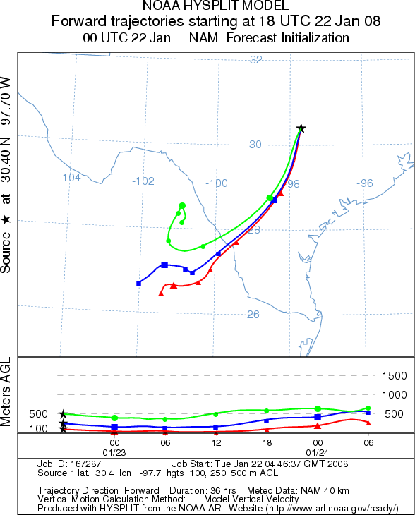
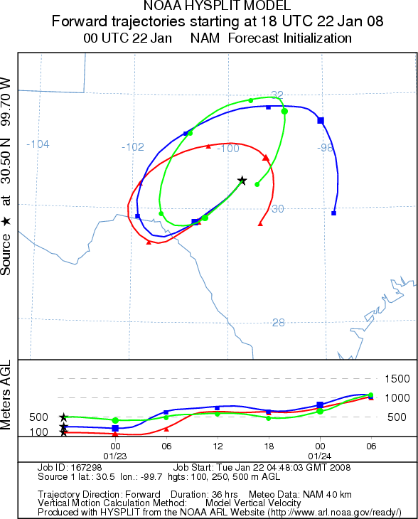
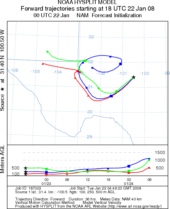
Trajectory Start (s) (shown by *
on map): Austin, TX; Junction, TX; San Angelo, TX.
AUSTIN
JUNCTION
SAN ANGELO
EDWARDS PLATEAU COMPOSITE
Prepared by: Estelle
Levetin (Faculty of Biological
Science, The University
of Tulsa, 600 S. College, Tulsa, OK 74104) and ) and Peter K Van de Water (Department
of Earth and Environmental Science, California State University Fresno, 2576 East San Ramon Avenue, M/S ST24, Fresno
CA 93740-8039). This forecast gives the anticipated future track of released Mountain Cedar pollen, weather conditions
over the region and along the forecast pathway, and an estimated time of arrival for various metropolitan areas.
Questions: Aerobiology Lab e-mail: pollen@utulsa.edu
Return to Forecasting Home Page