The University of Tulsa
Mountain Cedar Pollen Forecast
Metropolitan Area |
Exposure Risk |
|
Dallas/Fort Worth |
Moderate |
|
Austin |
Moderate |
|
San Antonio |
Moderate |
Date Issued: 28 January 2008
Mountain Cedar Location(s): Edwards Plateau, Texas
Regional Weather: Monday, January 28th TX/OK:
The weather today continues with mild conditions as temperatures rise back into the 60s and 70s toward the south.
The region will experience partly to mostly cloudy skies today. Winds will be from the south and strong with
sustained winds from 20 to 30 and gust as high as 45 mph from the south. Partly cloudy skies will remain across
the region tonight. Temperatures in Oklahoma will cool back into the low to upper 30s to the north and lower 40s
to the south. Winds will move to the southwest and will be moderate to strong, 15 to 20 mph. Tomorrow skies will
be mostly sunny with cooler conditions across Oklahoma. Temperatures to the north will be in the upper 40s and
upper 50s to the south. Winds will remain strong, 20 to 40 mph, from the northwest. In Texas, temperatures today
will climb into the upper 60s to mid 70s across the Edwards Plateau and into the upper 60s in the communities along
the Edwards Plateau edge. Winds will be moderate to strong with the strongest gusts occurring to the northwest.
Winds will be from the south and range from 10 to 15 up to 20 across the Edwards Plateau and in the edge communities.
Skies will be cloudy across the region with a chance of light rain. Overnight skies will remain cloudy with low
temperatures warm and but 5 to 10 degrees from the high temperatures in the edge communities and up to 20 degrees
cooler across the Edwards Plateau. Winds will remain light to moderate from the southwest on the Plateau and the
south in the surrounding communities. Tomorrow, skies will be cloudy to partly cloudy with clearing in the afternoon.
Temperatures will be in the lower 60s across the Edwards Plateau and in the 70s along the edge of the Edwards
Plateau. Winds will be moderate initially from the southwest shifting to the northwest during the afternoon becoming
strong along the edge of the Plateau. The edge communities will see a 20% chance of precipitation in the morning.
Trajectory weather: Cloudy skies today and warm conditions will be the hallmark of the southern Great Plains
today. The air mass trajectories move from the Edwards Plateau northward on moderate to strong winds across northern
Texas into eastern Oklahoma, across Arkansas and into eastern Missouri before heading towards the Ohio River Valley.
Trajectories from the eastern portion of the population should move further west, over northeastern Oklahoma versus
the western population in which the winds move the trajectories further towards the southeastern portion of Oklahoma.
Populations in the Arbuckle Mountains will be influenced by southerly winds that move the trajectories due north.
The pathway moves northward over northeast across Oklahoma into southeast Kansas and across Missouri, before moving
across the upper Midwest and into Canada above the Great Lakes. Tomorrow, winds will switch to the northwest.
Skies will be clearing and temperatures will cool by 15 to 20 degrees. Wind characteristics today are relatively
flat and heavy early but begin to show more buoyant conditions later. Todays atmospheric conditions suggest moderate
conditions for entrainment with moderate to strong winds for pollen transport. Weather conditions make for a forecast
of moderate to favorable for pollen release and entrainment from the Arbuckle Mountains population today.
OUTLOOK: ****Moderate threat today, Favorable conditions
for pollen release today, Favorable conditions for pollen entrainment and travel today***
Warm temperatures and drying conditions during the afternoons will create favorable conditions for pollen release
on the Edwards Plateau today and tomorrow even though temperatures will cool and winds will relax somewhat. However,
that being said we are now at the end of January which is usually the end of the Juniperus ashei pollination period.
Yet, pollen collection in the communities of Waco, Austin and San Antonio still indicate high concentrations of
Juniperus pollen. Juniperus virginiana (much less allergenic) traditionally starts pollination by the beginning
of February, thus we think that atmospheric pollen concentrations are beginning to be a mix of the two species
and that the Mountain Cedar pollen season is near its end. Therefore favorable conditions for pollen release, entrainment
and travel have been down graded to moderate, yet high levels of pollen in the atmosphere are expected. With good
atmospheric conditions and warm temperatures along with an increasingly dominant south wind, pollen dispersion
downwind will put allergy sufferers in north central Texas and across central to southeastern Oklahoma at risk
today and tomorrow.
Trajectory Start (s) (shown by *
on map): Austin, TX; Junction, TX; San Angelo, TX.
AUSTIN
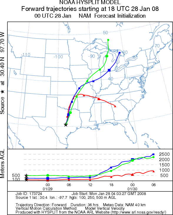
JUNCTION
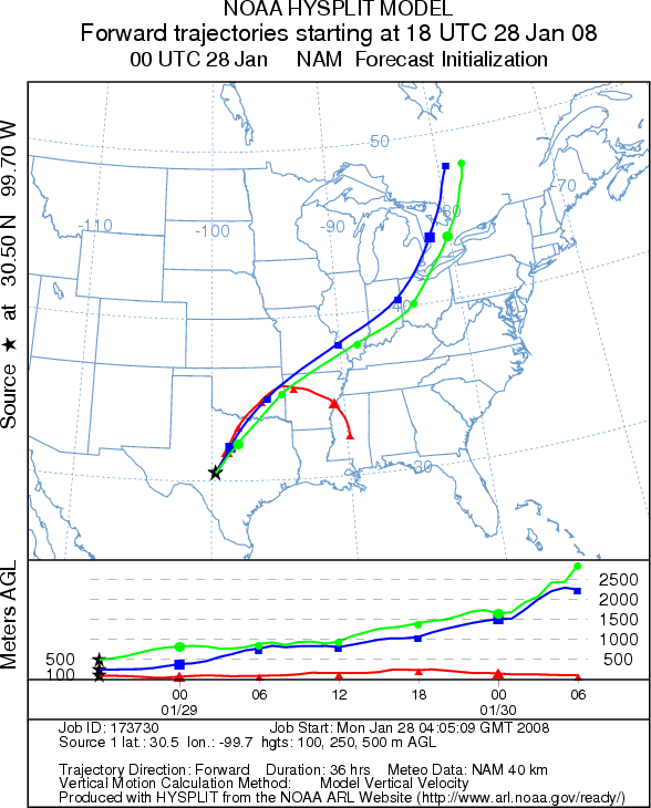
SAN ANGELO
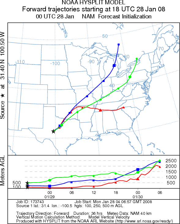
EDWARDS PLATEAU COMPOSITE
Prepared by: Estelle
Levetin (Faculty of Biological
Science, The University
of Tulsa, 600 S. College, Tulsa, OK 74104) and ) and Peter K Van de Water (Department
of Earth and Environmental Science, California State University Fresno, 2576 East San Ramon Avenue, M/S ST24, Fresno
CA 93740-8039). This forecast gives the anticipated future track of released Mountain Cedar pollen, weather conditions
over the region and along the forecast pathway, and an estimated time of arrival for various metropolitan areas.
Questions: Aerobiology Lab e-mail: pollen@utulsa.edu
Return to Forecasting Home Page