The University of Tulsa
Mountain Cedar Pollen Forecast
Metropolitan Area |
Exposure Risk |
|
Dallas/Fort Worth |
Low |
|
Austin |
High |
|
San Antonio |
High |
Date Issued: 12 January 2009
Mountain Cedar Location(s): Edwards Plateau, Texas
Regional Weather: Monday, Jan 12. TX/OK: A series
of cold fronts will move through the Texas-Oklahoma region over the next few days causing temperatures to see-saw
especially in Oklahoma. The first front will move into Oklahoma and west Texas this afternoon with gusty northwest
winds developing. The cold front will continue pushing south and east through central Texas overnight. The second
front will drop south across the plains states Wednesday into Thursday bringing another blast of cold air. Temperatures
today will reach the 50s in Oklahoma and the 60s in Texas ahead of the front. Skies will be clear to partly cloudy
with moderate to strong southwest to westerly winds shifting to northwest as the front passes. This is a dry front
with low humidity continuing in the region. Overnight lows will be in the low to mid 20s in Oklahoma and upper
20s and low 30s in Texas with north to northwest winds and clear skies. Temperatures tomorrow will be in the upper
30s to mid 40s in Oklahoma. Highs tomorrow in Texas will be 8 to 10 degrees cooler than today with highs in the
upper 50s and low 60s. Winds will be from the north during the morning tomorrow and gradually swinging back around
to the south in the afternoon.
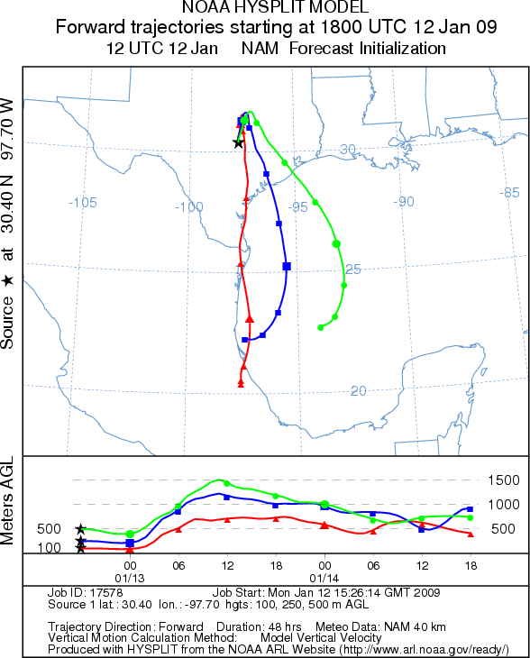
Trajectory weather: The air mass trajectories from the Edwards Plateau begin moving north and northeast
and then turn south under the influence of the cold front that will move into Texas this afternoon and evening.
Trajectory characteristics are mixed for downwind dispersal. At the source areas today along the Plateau temperatures
will be in the mid-60s with clear skies and moderate winds. Winds will be shifting during the afternoon to northwest
winds as the cold front moves into the area. Overnight temperatures will be in the upper 20s to low 30s with northwest
winds. Temperatures tomorrow will warm into the upper 50s to low 60s. The trees are in the peak of the pollination
period so significant release should be expected.
OUTLOOK: *** High Threat today *** Good conditions for pollen release.
Sunny skies with dry windy conditions and mild temperatures are favorable for pollen release. Since the trees
are nearing their peak pollination period significant amounts of pollen release might be expected. The trajectory
characteristics do not show perfect atmospheric conditions leading to entrainment and travel downwind so pollen
may remain close to the source areas.
Trajectory Start (s) (shown by *
on map): Austin, TX; Junction, TX; San Angelo, TX.
AUSTIN
JUNCTION
SAN ANGELO
EDWARDS PLATEAU COMPOSITE
Prepared by: Estelle
Levetin (Faculty of Biological
Science, The University
of Tulsa, 800 S. Tucker Dr., Tulsa, OK 74104) and ) and Peter K Van de Water (Department
of Earth and Environmental Science, California State University Fresno, 2576 East San Ramon Avenue, M/S ST24, Fresno
CA 93740-8039). This forecast gives the anticipated future track of released Mountain Cedar pollen, weather conditions
over the region and along the forecast pathway, and an estimated time of arrival for various metropolitan areas.
Questions: Aerobiology Lab e-mail: pollen@utulsa.edu
Return to Forecasting Home Page