The University of Tulsa
Mountain Cedar Pollen Forecast
Metropolitan Area |
Exposure Risk |
|
Dallas/Fort Worth |
Low |
|
Austin |
Moderate |
|
San Antonio |
Moderate |
Date Issued: 26 January 2009
Mountain Cedar Location(s): Edwards Plateau, Texas
Regional Weather: Monday, January 26 TX/OK:
Across the region the weather will be increasingly affected by the movement of cold air from the north today and
tomorrow. In Oklahoma, cold temperatures have already arrived with readings in the upper 20s and mid 30s today
and tomorrow. Skies will be cloudy with likelihood of rain, freezing rain, sleet or snow both today and tomorrow.
Winds will be moderate starting from the east today, switching towards the northeast overnight and then from the
north tomorrow. Temperatures will be in the upper 20s tonight and upper teens and lower 20s tomorrow night. In
Texas, warm weather will occur today ahead of the cold air moving into the area. Today, temperatures will range
from the upper 40s in the north to the upper 60s and low 70s in the south. Across the region skies will be cloudy
with a 20% chance of precipitation today, tonight and tomorrow. The chance of rain will increase on the Plateau
tomorrow night. Winds today will be from the southeast and moderate to strong across the region. Late tonight
and tomorrow morning winds will turn, coming out of the north as the cold front moves southward. As cold air moves
in to the region temperatures will cool by 30 degrees or more with areas on the Plateau potentially seeing drizzle
and freezing fog overnight on Tuesday night.
Trajectory weather: Air mass trajectories from the western part of the Plateau move to the north than northeast.
Trajectory characteristics are good for entrainment and travel from this area. Trajectories for the eastern side
of the Plateau move towards the north but then are variable as the cold front moves into the region. Cloudy skies
today and tonight, with cooling conditions and the chance of precipitation will occur across Texas. Winds will
be moderate, gaining in strength in the afternoon as the cold front approaches. Sometime tonight or tomorrow winds
will switch coming from the north and maintaining moderate to strong conditions. Cloudy skies will be accompanied
by an increasing chance of precipitation across the region. Conditions in the tree population on the Edwards Plateau
will be moderate today in front of the incoming cold conditions. Any pollen entrained into the air will have a
chance to move long distances to the northeast (see the 500 m winds). At the ground level, however conditions
for entrainment will be marginal to poor.
OUTLOOK: *** Moderate Threat *** mixed conditions for pollen release today along with
mixed conditions for entrainment and transport today. Moderate conditions with moderate to strong winds, but
with cloudy skies and heightened humidity levels will present less than optimal conditions for pollen release,
but with moderate conditions for entrainment and travel where pollen is released. The dense population of trees
in the surrounding communities may result in significant pollen levels in the atmosphere, thus both Austin and
San Antonio may see moderate pollen conditions. Winds in the eastern part of the region will be towards the northwest
today then will turn southward as a cold front moves into the region. The overall mixed conditions today will
give way to colder conditions tomorrow and tomorrow night with an increasing chance of precipitation and much higher
humidity. Winds will remain moderate to strong throughout the region changing toward and dominant north to south
direction.
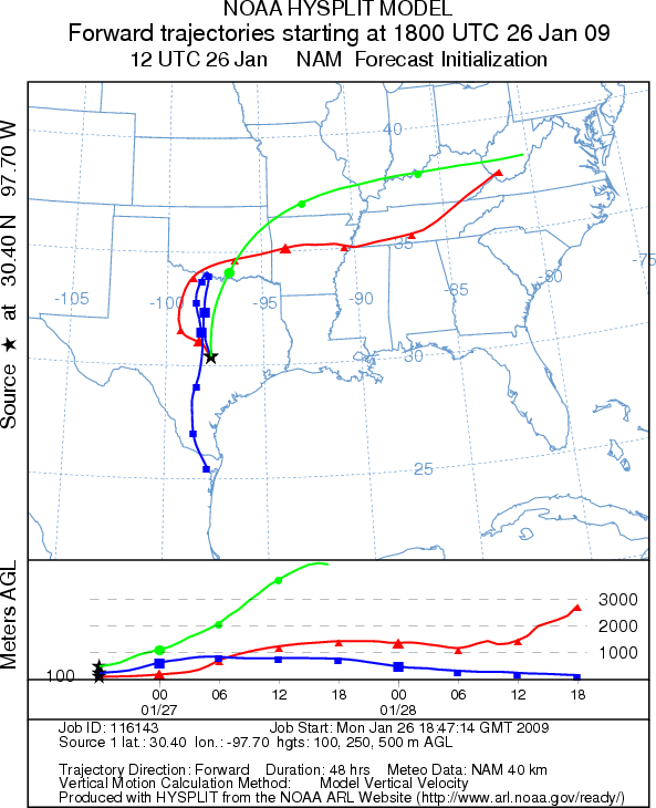
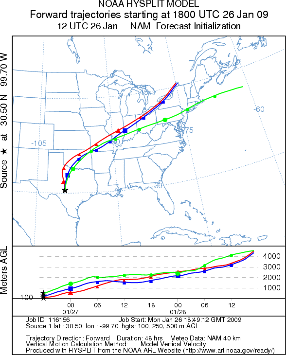
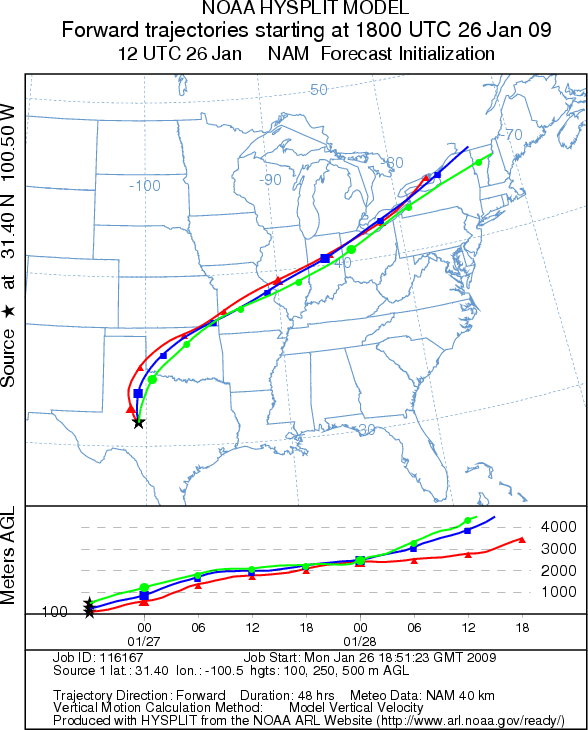
Trajectory Start (s) (shown by *
on map): Austin, TX; Junction, TX; San Angelo, TX.
AUSTIN
JUNCTION
SAN ANGELO
EDWARDS PLATEAU COMPOSITE
Prepared by: Estelle
Levetin (Faculty of Biological
Science, The University
of Tulsa, 800 S. Tucker Dr., Tulsa, OK 74104) and ) and Peter K Van de Water (Department
of Earth and Environmental Science, California State University Fresno, 2576 East San Ramon Avenue, M/S ST24, Fresno
CA 93740-8039). This forecast gives the anticipated future track of released Mountain Cedar pollen, weather conditions
over the region and along the forecast pathway, and an estimated time of arrival for various metropolitan areas.
Questions: Aerobiology Lab e-mail: pollen@utulsa.edu
Return to Forecasting Home Page