The University of Tulsa
Mountain Cedar Pollen Forecast
Metropolitan Area |
Exposure Risk |
|
Dallas/Fort Worth |
Low |
|
Austin |
Low to Moderate |
|
San Antonio |
Low to Moderate |
Date Issued: 28 January 2009
Mountain Cedar Location(s): Edwards Plateau, Texas
Regional Weather: Wednesday, January 28 TX/OK:
Across the region the weather will be improving, returning to somewhat warmer conditions this afternoon. In Oklahoma,
high temperatures will be in the upper 20s and low 30s today after overnight lows in the teens. Temperatures will
be warming to the 40s on Thursday. Winds today will be light and variable increasing to moderate conditions tonight,
tomorrow and tomorrow night. Skies today will be mostly sunny, then partly cloudy tonight and tomorrow clearing
towards tomorrow evening. In Texas, temperatures are low this morning ranging from the teens to the low 40s. Skies
range from clear to mostly cloudy across the Plateau. Later this afternoon skies will turn sunny and high temperatures
are expected to reach into the 50s with moderate variable winds. Tonight skies will be mostly clear with cold temperatures
into the upper 20s and lower 30s. On Thursday skies will be sunny to partly cloudy across the area with temperatures
in the upper 50s to lower 60s. On Thursday winds will shift out of the northeast at moderate levels.
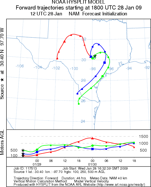
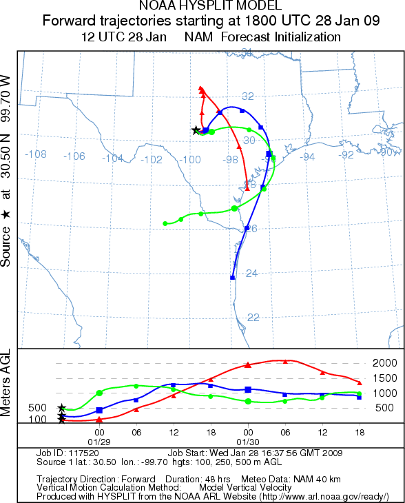
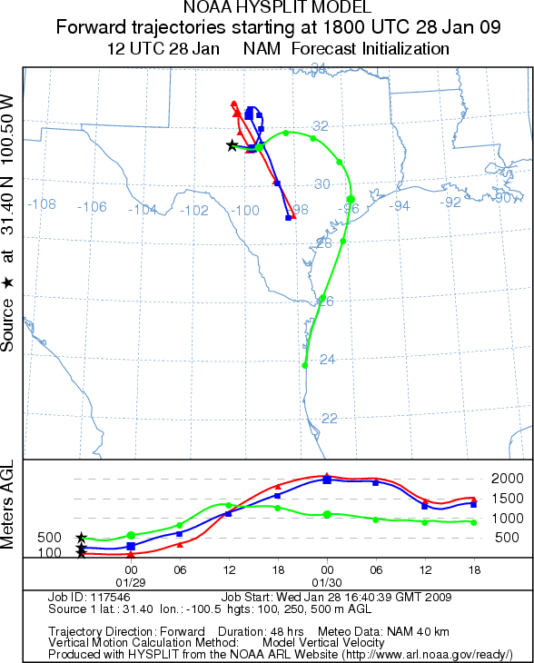
Trajectory weather: Air mass trajectories from the Edwards Plateau circle around central and west Texas
for the next 48 hours. The atmosphere will remain cold and dense moving near ground level initially but start to
rise as the air becomes more buoyant. The wintry weather has moved out of the region and sunny to partly cloudy
skies will return with temperatures reaching into the 50s later this afternoon after low morning temperatures.
On the Edwards Plateau winds will be moderate and variable. Mostly clear skies will occur overnight with cold temperatures
in the upper 20s and lower 30s. Tomorrow sunny to partly cloudy skies will reign across the region with temperatures
increasing into the 50s on the Plateau and reaching towards the low 60s in the surrounding communities. Winds will
be from the north and northeast, moving towards a more easterly direction tomorrow night.
OUTLOOK: *** Low to Moderate Threat *** poor conditions
for pollen release this morning along with poor conditions for entrainment and transport. Cold conditions this
morning after low overnight temperatures morning should restrict pollen release throughout the region. However,
warming conditions late in the day may be enough to result in some restricted pollen release. The atmosphere will
remain humid and cold both conditions that are poor for pollen release and entrainment. Winds will be moderate
throughout the region therefore any entrained pollen will not move significant distances. On Thursday conditions
will begin to improve as sunny skies return and temperatures begin to warm. As conditions warm and dry the potential
for pollen release will return, coupled with more buoyant atmospheric conditions for entrainment and downwind travel.
Trajectory Start (s) (shown by *
on map): Austin, TX; Junction, TX; San Angelo, TX.
AUSTIN
JUNCTION
SAN ANGELO
EDWARDS PLATEAU COMPOSITE
Prepared by: Estelle
Levetin (Faculty of Biological
Science, The University
of Tulsa, 800 S. Tucker Dr., Tulsa, OK 74104) and ) and Peter K Van de Water (Department
of Earth and Environmental Science, California State University Fresno, 2576 East San Ramon Avenue, M/S ST24, Fresno
CA 93740-8039). This forecast gives the anticipated future track of released Mountain Cedar pollen, weather conditions
over the region and along the forecast pathway, and an estimated time of arrival for various metropolitan areas.
Questions: Aerobiology Lab e-mail: pollen@utulsa.edu
Return to Forecasting Home Page