The University of Tulsa
Mountain Cedar Pollen Forecast

The University of Tulsa
Mountain Cedar Pollen Forecast
Metropolitan Area |
Exposure Risk |
|
Oklahoma City |
Low |
|
Tulsa |
Low |
|
St. Louis MO |
Low |
Date Issued: 6 January 2010
Mountain Cedar Location(s): Arbuckle Mountains, OK
Regional Weather: Wednesday, January 6 TX/OK:
Across the region the weather will continue cool with changes beginning to signal the movement of significantly
cold air and winter precipitation into the area tonight. Temperatures today will be in the 50s across Texas and
the 40s in Oklahoma. Increasing humidity and increased wind strength will occur into the afternoon and tonight.
Tonight skies are expected to be mostly cloudy region wide and a chance of rain, drizzle and eventually snow overnight
with warmer conditions south versus north. In Texas, tonights lows are expected to be in the 20s on the Edwards
Plateau, the low thirties in the surrounding communities and in the 20s and teens in northern Texas and on into
Oklahoma. In the communities surrounding the Edwards Plateau and northward there is a 20% to 30% chance of precipitation
tonight. Winds will increase overnight from the south and southwest starting moderate but building strong and
gusty conditions. Winds speeds tonight on the western sections of the Edwards Plateau may get to 20 to 25 miles
sustained winds with gusts up towards 40 miles per hour. Tomorrow cold conditions will begin to arrive with temperatures
across the area in the teens and twenties to the north and low thirties to the south. Winds will turn coming from
the north and be moderate to strong. Thursday night conditions will continue to deteriorate with temperatures
in the teens region wide and winds remaining moderate from the north.
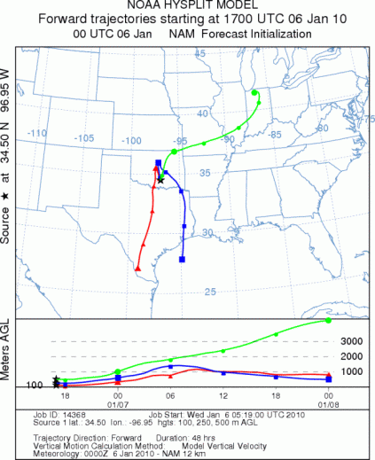
Trajectory weather: Mostly cloudy skies, cold conditions and moderate winds from the southeast will occur
across Oklahoma today. Mostly cloudy to cloudy skies are in the forecast for today,tonight , tomorrow and tomorrow
night. Temperatures in central Oklahoma will continue to be cold after today. Todays high is expected to be
in the 40s, cooling to the teens tonight, barely getting above the high teens to low twenties tomorrow, and down
to the single digits tomorrow night. Surface winds will be from the southeast today switching, coming from the
north, today and gaining strength into tomorrow. Today and tomorrow, the surface trajectories move southward whereas
those at upper elevations in the atmosphere are caught into the larger weather pattern. The air appears stable,
initially, but as the cold air moves in from the north turbulence will cause it to be buoyant. With the cold temperatures,
cloudy skies and higer humicdity no pollen release is expected.
OUTLOOK: *** Low Threat today; Low threat tomorrow *** Poor conditions for pollen
release today and Poor conditions tomorrow; Poor conditions for entrainment and transport today, Poor conditions
tomorrow. Cold conditions with moderate to strong wind speeds building overnight into tomorrow. Partly cloudy
skies near the Arbuckle Mountain population are expected today and tomorrow. Temperatures are cooling to cold
conditions tomorrow night and into the weekend. No significant release of pollen is expected from the population.
The atmosphere will be stable and without significant pollen, entrainment and travel is not expected.. For these
reasons the threat today and tomorrow is low and the chance of pollination, entrainment and travel is poor.
Trajectory Start (s) (shown by black star on map): Davis, OK.
Prepared by: Estelle
Levetin
(Faculty
of Biological Science, The University of Tulsa, 800 S. Tucker Dr., Tulsa, OK 74104) and Peter
K Van de Water
(Department of Earth and Environmental Science, California State University Fresno, 2576 East San Ramon Avenue,
M/S ST24, Fresno CA 93740-8039). This forecast gives the anticipated future track of released Mountain Cedar pollen,
weather conditions over the region and along the forecast pathway, and an estimated time of arrival for various
metropolitan areas.
Questions: Aerobiology Lab e-mail: pollen@utulsa.edu
Return to Forecasting Home Page