The University of Tulsa
Mountain Cedar Pollen Forecast

The University of Tulsa
Mountain Cedar Pollen Forecast
SATURDAY / SUNDAY
Metropolitan Area |
Exposure Risk |
|
Oklahoma City |
Low / Moderate |
|
Tulsa |
Low / Moderate |
|
St. Louis MO |
Low / Low |
Date Issued: 9 January 2010
Mountain Cedar Location(s): Arbuckle Mountains, OK
Regional Weather: Saturday, January 09 TX/OK:
Across the region the weather will continue cold but will start to warm with high temperatures in the 20s and 30s
north and the 40s across the Texas region today. Tomorrow temperatures will warm by at least 10 degrees with highs
expected in the upper 30s and lower 40s north and into the low to 50s in the warmer areas of Texas. The Edwards
Plateau is expected to be in the upper 40s to 50. Across the region skies will be sunny today, mostly clear to
clear tonight, and Sunny with clear skies tomorrow and tomorrow night. Tonight temperatures will be in the teens
region wide. Tomorrow night low temperatures will warm into the 20s as warming begins from the cold conditions
of this week. Today, winds will be light and variable across Oklahoma. In northern Texas and in the edge communities
around the Edwards Plateau winds will be light and from the northeast. The Edwards Plateau itself will see moderate
winds from the south and southeast. Winds will remain from the same direction tonight at light to moderate conditions.
Tomorrow morning winds start light but build to moderate conditions in the afternoon, then slacken overnight as
it shifts coming from the south region wide.
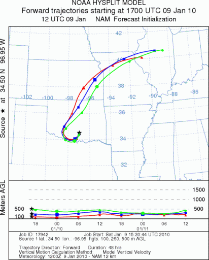
Trajectory weather: Sunny skies will occur across Oklahoma today and tomorrow with cold temperatures entrenched
across the region. Todays highs will be in the 20s in central Oklahoma and pushing into the mid 30s southward
in the Arbuckle Mountains. Winds will remain light from the northeast today and tonight in Oklahoma. Tomorrow winds
will shift, coming from the south, but maintaining light wind strength. Tomorrow night wind strength will increase
to moderate conditions. Today, the trajectories move initially southward on light winds then as the wind direction
shifts on Sunday and increases wind speed the air begins to move northward over Tulsa and into northern Arkansas
and southern Missouri. The air is stable and cold, thus pollination will be restricted from the area today and
tomorrow. Tomorrow trajectories move the atmosphere northward on the same track as today, but cold conditions will
once more restrict pollen release.
OUTLOOK: *** Low Threat today; Low threat tomorrow *** Poor conditions for pollen
release today and Poor conditions tomorrow; Poor conditions for entrainment and transport today, Poor conditions
tomorrow. Sunny skies but cold conditions, along with light winds result in poor conditions for pollen release
and poor conditions for entrainment and travel today and tomorrow. For these reasons there is a low threat from
the Arbuckle tree populations today and tomorrow. However, winds from Texas, where conditions will improve tomorrow
may bring atmospheric concentrations of pollen over the central to eastern areas of Oklahoma. Because of the threat
from further south moderate threat is listed for Oklahoma City and Tulsa.
Trajectory Start (s) (shown by black
star on map): Davis, OK.
SATURDAY
SUNDAY
Prepared by: Estelle
Levetin
(Faculty
of Biological Science, The University of Tulsa, 800 S. Tucker Dr., Tulsa, OK 74104) and Peter
K Van de Water
(Department of Earth and Environmental Science, California State University Fresno, 2576 East San Ramon Avenue,
M/S ST24, Fresno CA 93740-8039). This forecast gives the anticipated future track of released Mountain Cedar pollen,
weather conditions over the region and along the forecast pathway, and an estimated time of arrival for various
metropolitan areas.
Questions: Aerobiology Lab e-mail: pollen@utulsa.edu
Return to Forecasting Home Page