
The University of Tulsa
Mountain Cedar Pollen Forecast
Metropolitan Area |
Exposure Risk |
|
Dallas/Fort Worth |
Low |
|
Austin |
Low |
|
San Antonio |
Low |
Date Issued: 14 January 2010
Mountain Cedar Location(s): Edwards Plateau, Texas
Regional Weather: Thursday, January 14 TX/OK:
Across the region the weather will be seasonally warm but with high humidity and cloudy skies. Beginning today
an increasing chance of showers will occur from south to north. In Oklahoma temperatures will be in the low 50s
with winds from the south at 10 miles per hour. There is a 20% chance of precipitation in southern Oklahoma.
In Texas temperatures till be in the 60s in the communities surrounding the Edwards Plateau where temperatures
will be in the mid to upper 50s. The edge communities will have moderate southeast winds with a 60% chance of
precipitation today. On the Plateau winds will be from the southeast and moderate with a 50% chance of precipitation.
Tonight temperatures will drop into the 30s in Oklahoma but will be in the upper 40s and lower 50s across Texas.
Winds will switch from the southeast to a northeast direction and be lilght to moderate. The chance of precipitation
increases region wide with the edge communities at 100% and the Edwards Plateau between 70% and 90% chance of precipitation.
Friday will continue to be cloudy with rain across the region. Temperatures will cool into the low to mid 50s
and winds will be moderate from the northeast. Wet conditions will occur region wide then start to tail off Friday
night into Saturday.
Trajectory weather: Conditions today will be warm but be increasingly wet as rain moves into the region.
Winds will be moderate today and tonight but will pick up their strength tomorrow with the edge communities seeing
gusts in the 30 mile an hour range. Temperatures will be in the 50s and 60s today but with cloudy skies and showers.
Tonight rain is expected and temperatures will drop only 5 to 10 degrees from daytime levels. Winds will switch
from the southeast to the northeast overnight.
OUTLOOK: *** Low Threat today; Low threat tomorrow *** Poor conditions for pollen
release today and Poor conditions tomorrow; Poor conditions for entrainment and transport today, Poor conditions
tomorrow. Warm temperatures today, tonight, tomorrow and tomorrow night would be good for pollen release, but
precipitation is expected across the region over the next two days. No pollen release is expected because of the
wet weather conditions. Winds will be moderate today increasing to gusty conditions in the edge communities tomorrow.
The atmosphere will begin relatively stable today but as low pressure moves through the area it will become more
buoyant. The high humidity and rain in the region should wash out any pollen that might get into the atmosphere.
With no pollen expected to be released to the atmosphere conditions for entrainment and travel is of minor importance.
Trajectory Start (s) (shown by *
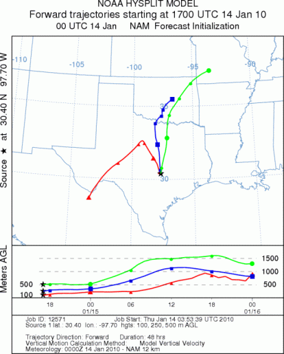
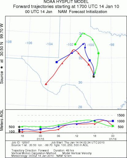
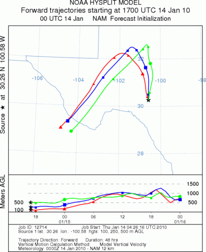
on map): Austin, TX; Junction, TX; Sonora, TX.
AUSTIN
JUNCTION
SONORA
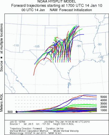
EDWARDS PLATEAU COMPOSITE
Prepared by: Estelle
Levetin (Faculty of Biological
Science, The
University of Tulsa, 800 S. Tucker Dr., Tulsa, OK 74104) and ) and Peter
K Van de Water (Department of Earth and Environmental Science, California State University Fresno,
2576 East San Ramon Avenue, M/S ST24, Fresno CA 93740-8039). This forecast gives the anticipated future track of
released Mountain Cedar pollen, weather conditions over the region and along the forecast pathway, and an estimated
time of arrival for various metropolitan areas.
Questions: Aerobiology Lab e-mail: pollen@utulsa.edu
Return to Forecasting Home Page