The University of Tulsa
Mountain Cedar Pollen Forecast

Metropolitan Area |
Exposure Risk |
|
Oklahoma City |
Low |
|
Tulsa |
Low |
|
St. Louis MO |
Low |
Date Issued: 15 January 2010
Mountain Cedar Location(s): Arbuckle Mountains, OK
Regional Weather: Friday, January 15 TX/OK: Across
the region the weather will be wet as moisture is pumped northward from the Gulf of Mexico. Cloudy skies will dominate.
Temperatures will be in the upper 40s to lower 50s north and lower to mid 50s across Texas. Winds will be from
the north to northeast, with moderate conditions ranging from 10 to 20 miles per hour across the region. To the
north in Oklahoma there is a 40% chance of precipitation in the area with the Juniperus ashei tree population.
In Texas the chance of precipitation increases with most areas off of the Plateau at 100% chance. On the Plateau
the chance of precipitation ranges from 70% in the east to 90% in Junction and Sonora. Tonight cloudy conditions
will continue with showers tapering off first on the Edwards Plateau then in the surrounding communities. The Plateau
will see the chance of precipitation drop to 50% in San Angelo and Sonora with Junction maintaining 70%. In the
surrounding communities of Austin and San Antonio a 90% chance of precipitation will remain. Tomorrow cloudy skies
initially will eventually give way to partly sunny conditions in the edge communities and partly cloudy conditions
over the plateau. Temperatures will warm into the upper 50s with San Antonio expecting to reach 60. The chance
of rain will dissipate with the clearing skies although a 20% to 30% chance exists in the morning in most areas.
Winds will calm to light conditions from the northwest. Tomorrow night temperatures will be in the lower to mid
30s to the north and upper 30s to low 40s across Texas. Winds will be light from the south and southwest across
the Plateau and surrounding communities. In northern Texas and across Oklahoma winds will be light and variable.
Trajectory weather: At the source area in the Arbuckles, there will be mostly cloudy to cloudy skies today
with a 40% chance of precipitation. Temperatures will be in the lower 50s and winds light. Tonight the chance of
precipitation is reduced with mostly cloudy skies and temperatures in the upper 30s. On Saturday skies will be
partly cloudy with temperatures returning to the upper 50s. Winds, however will be light and variable. Tomorrow
night partly cloudy to clear skies will prevail with temperatures in the lower 30s and light and variable wind
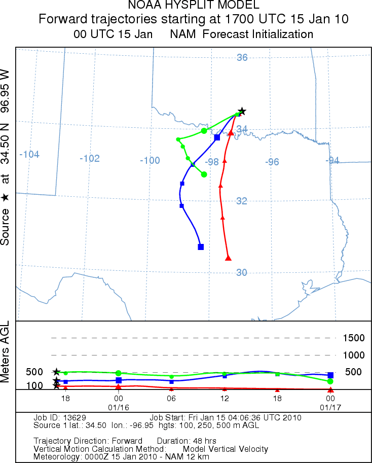
conditions. Today the surface trajectories move southward at ground level driven by moderate winds. The air appears
stable. Because of wet conditions little pollen release is expected. With the light and variable winds poor conditions
for entrainment and travel are expected for any pollen that might be shed.
OUTLOOK: *** Low Threat today; Low threat tomorrow *** Poor conditions for pollen
release today and tomorrow; Poor conditions for entrainment and transport today and tomorrow. Wet conditions
with moderate wind speeds today decreasing to light and variable winds tonight and tomorrow provide poor conditions
for pollen release today and tomorrow. No pollen release is expected. Winds will be moving towards the south on
light winds. For these reasons the threat today and tomorrow is low and the chance of pollination, entrainment
and travel is poor.
Trajectory Start (s) (shown by black
star on map): Davis, OK.
Prepared by: Estelle
Levetin
(Faculty
of Biological Science, The University of Tulsa, 800 S. Tucker Dr., Tulsa, OK 74104) and Peter
K Van de Water
(Department of Earth and Environmental Science, California State University Fresno, 2576 East San Ramon Avenue,
M/S ST24, Fresno CA 93740-8039). This forecast gives the anticipated future track of released Mountain Cedar pollen,
weather conditions over the region and along the forecast pathway, and an estimated time of arrival for various
metropolitan areas.
Questions: Aerobiology Lab e-mail: pollen@utulsa.edu
Return to Forecasting Home Page