The University of Tulsa
Mountain Cedar Pollen Forecast

Metropolitan Area |
Exposure Risk |
|
Oklahoma City |
High |
|
Tulsa |
High |
|
St. Louis MO |
Low |
Date Issued: 22 January 2010
Mountain Cedar Location(s): Arbuckle Mountains, OK
Regional Weather: Friday, January 22 - TX/OK:
Across the region the weather will remain seasonably warm with temperatures in the 70s today and cooling by about
5 degrees tomorrow. Skies will be sunny and mostly sunny today across Texas with partly cloudy skies across Oklahoma.
Winds will be moderate to strong and from the south with wind speeds in many places building towards the afternoon..
Tonight partly cloudy to mostly cloudy skies will dominate the region. There is an increasing chance of precipitation
and thunderstorms as a system moves in from the west. Temperatures will be in the mid to upper 40s from central
Oklahoma towards the border region with Texas. In Texas, temperatures will be in the mid to upper 50s in the
surrounding communities and in the lower 50s across the Edwards Plateau falling into the upper 40s towards the
west. Winds will remain strong across Oklahoma and Texas and from the south. Temperatures will once again climb
into the 60s to the north 70s in the communities surrounding the Edwards Plateau where temperatures will reach
the upper 60s. A chance of precipitation will remain in the communities surrounding the Edwards Plateau. Winds
will switch, coming out of the west to southwest over much of Texas with wind strength starting at moderate levels
but building towards the afternoon to strong levels. Saturday night, skies will be partly cloudy from central
Oklahoma south to the communities surrounding the Plateau. On the Plateau, skies will be mostly clear. Temperatures
will be in the upper 30s north to 40s across the rest of the region. Winds will be from the west to southwest
maintaining moderate to strong conditions.
Trajectory weather: Partly cloudy skies, but seasonally warm temperatures in the lower 60s and moderate
to strong southerly winds will occur across Oklahoma today. Cloudy skies are in the forecast for tonight with
temperatures in the upper 40s and a 50% to 60% chance of precipitation. Tomorrow and tomorrow night partly cloudy
to cloudy skies will prevail with tomorrows temperatures remaining in the 60s. Winds will remain at moderate to
strong conditions coming out of the south. Friday night there will be partly cloudy skies and temperatures will
drop into the 30s and lower 40s. Wind will decrease to light levels and switch from the southerly flow to coming
out of the west and northwest. The air appears buoyant rising as it travels northward away from the Arbuckle population.
Warm temperatures, with partly cloudy skies will result in good conditions for release today but with rain forecast
tomorrow moderate conditions are expected. In addition the area will see strong winds today, tonight and tomorrow.
Conditions are good and the cones ripe thus pollen release into the atmosphere is expected today but less so
tomorrow with forecast precipitation. Strong winds will result in entrainment and long distance travel distances
unless precipitation washes the pollen out..
OUTLOOK: *** High Threat today; Moderate threat tomorrow
***Good conditions for pollen release today and Moderate conditions tomorrow;Good conditions for entrainment and
transport today, Moderate conditions tomorrow. Warm conditions with moderate to strong wind speeds will occur
today. Partly cloudy skies today near the Arbuckle Mountain population with warm temperatures are expected and
are good conditions for release. We should be near the height of the season for cone ripening thus there could
be a significant pulse of pollen into the atmosphere. Tonight and tomorrow the increasing chance of precipitation
should dampen pollen release, but with cleary conditions and strong winds in the afternoon moderate levels are
expected. The atmosphere will be buoyant with strong wind strength, therefore good conditions exist for entrainment
and travel. Entrained pollen from the Arbuckles and Texas will be carried north across the state on strong winds
into the upper Great Plains. Today with increasing wind strength the chance of entrainment and long distance travel
increases, however the chance of thunderstorms could wash some of the pollen from the skies.. For these reasons
the threat today and tomorrow for release is good but the chance of entrainment and travel will vary.
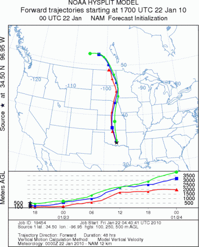
Trajectory Start (s) (shown by black
star on map): Davis, OK.
Prepared by: Estelle
Levetin
(Faculty
of Biological Science, The University of Tulsa, 800 S. Tucker Dr., Tulsa, OK 74104) and Peter
K Van de Water
(Department of Earth and Environmental Science, California State University Fresno, 2576 East San Ramon Avenue,
M/S ST24, Fresno CA 93740-8039). This forecast gives the anticipated future track of released Mountain Cedar pollen,
weather conditions over the region and along the forecast pathway, and an estimated time of arrival for various
metropolitan areas.
Questions: Aerobiology Lab e-mail: pollen@utulsa.edu
Return to Forecasting Home Page