
The University of Tulsa
Mountain Cedar Pollen Forecast
Metropolitan Area |
Exposure Risk |
|
Dallas/Fort Worth |
High |
|
Austin |
High |
|
San Antonio |
High |
Date Issued: 22 January 2010
Mountain Cedar Location(s): Edwards Plateau, Texas
Regional Weather: Friday, January 22 TX/OK:
Across the region the weather will remain seasonably warm with temperatures in the 70s today and cooling by about
5 degrees tomorrow. Skies will be sunny and mostly sunny today across Texas with partly cloudy skies across Oklahoma.
Winds will be moderate to strong and from the south with wind speeds in many places building towards the afternoon..
Tonight partly cloudy to mostly cloudy skies will dominate the region. There is an increasing chance of precipitation
and thunderstorms as a system moves in from the west. Temperatures will be in the mid to upper 40s from central
Oklahoma towards the border region with Texas. In Texas, temperatures will be in the mid to upper 50s in the
surrounding communities and in the lower 50s across the Edwards Plateau falling into the upper 40s towards the
west. Winds will remain strong across Oklahoma and Texas and from the south. Temperatures will once again climb
into the 60s to the north 70s in the communities surrounding the Edwards Plateau where temperatures will reach
the upper 60s. A chance of precipitation will remain in the communities surrounding the Edwards Plateau. Winds
will switch, coming out of the west to southwest over much of Texas with wind strength starting at moderate levels
but building towards the afternoon to strong levels. Saturday night, skies will be partly cloudy from central
Oklahoma south to the communities surrounding the Plateau. On the Plateau, skies will be mostly clear. Temperatures
will be in the upper 30s north to 40s across the rest of the region. Winds will be from the west to southwest
maintaining moderate to strong conditions.
Trajectory weather: Conditions today will be warm and sunny across most of the Texas region. Winds will
be moderate building in strength from the south and temperatures in the mid to upper 70s in the communities surrounding
the Edwards Plateau, as well as on the Plateau. Tonight the area will see partly to mostly cloudy skies with a
20% to 30% chance of precipitation. Temperatures overnight will be in the mid to low 50s, with the coolest conditions
to the west. Winds will be from the south to southwest at moderate conditions. Tomorrow the surrounding areas
will be partly sunny north and mostly cloudy in the surrounding communities and on the Edwards Plateau. Winds
will be from the west and southwest during the day starting at moderate conditions and building towards strong
conditions in the afternoon. Tomorrow night partly cloudy skies will occur in areas surrounding the Plateau where
it will be mostly clear conditions. Across the region temperatures will be in the 40s. Winds will remain from
the west and southwest at moderate conditions. The trajectories move towards the north today and tonight. The
atmosphere starts relatively stable for the first 12 hours of the day but then becomes buoyant over the rest of
the forecast period.
OUTLOOK: *** High Threat today; High threat tomorrow ***Good conditions for pollen
release today and Good conditions tomorrow; Good conditions for entrainment and transport today,Good conditions
tomorrow. Warm temperatures and mostly sunny skies today, although cloudy skies will occur tonight and a chance
of precipitation especially to the north. Tomorrow partly cloudy to mostly cloudy skies with a slight chance of
rain in the surrounding communities, will occur. Temperatures will remain relatively warm, 60s on the Plateau
over the primary tree populations, thus along with moderate to strong building winds make for good pollen release
conditions, entrainment and travel. Friday afternoon and night winds will begin to shift from the south to the
southwest and west in some areas. The atmosphere will begin relatively stable today but as low pressure moves
through the area it will become more buoyant. The high humidity and rain in the region tonight could wash out
any pollen that might get into the atmosphere, especially as it moves northward. Because of the good conditions
for pollen release as well as entrainment and travel a high threat exist today and tomorrow. .
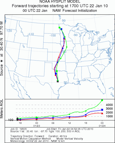
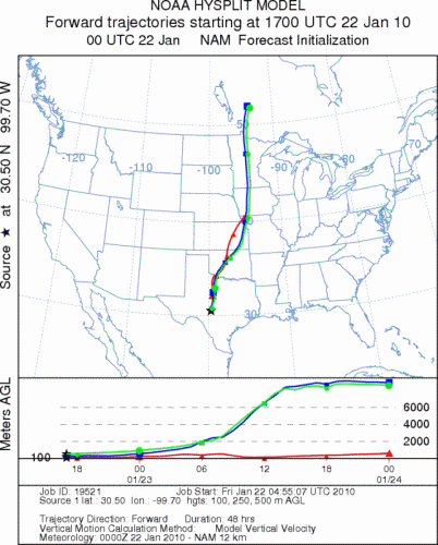
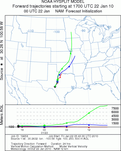
Trajectory Start (s) (shown by *
on map): Austin, TX; Junction, TX; Sonora, TX.
AUSTIN
JUNCTION
SONORA
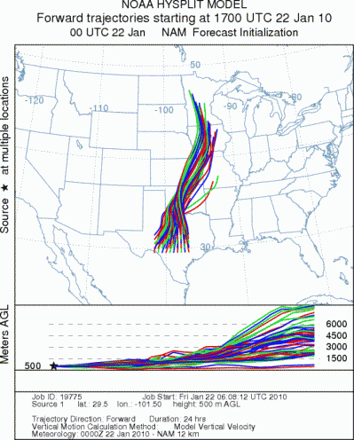
EDWARDS PLATEAU COMPOSITE
Prepared by: Estelle
Levetin (Faculty of Biological
Science, The
University of Tulsa, 800 S. Tucker Dr., Tulsa, OK 74104) and ) and Peter
K Van de Water (Department of Earth and Environmental Science, California State University Fresno,
2576 East San Ramon Avenue, M/S ST24, Fresno CA 93740-8039). This forecast gives the anticipated future track of
released Mountain Cedar pollen, weather conditions over the region and along the forecast pathway, and an estimated
time of arrival for various metropolitan areas.
Questions: Aerobiology Lab e-mail: pollen@utulsa.edu
Return to Forecasting Home Page