The University of Tulsa
Mountain Cedar Pollen Forecast

The University of Tulsa
Mountain Cedar Pollen Forecast
SATURDAY / SUNDAY
Metropolitan Area |
Exposure Risk |
|
Oklahoma City |
Low / Low |
|
Tulsa |
Moderate / Low |
|
St. Louis MO |
Low / Low |
Date Issued: 23 January 2010
Mountain Cedar Location(s): Arbuckle Mountains, OK
Regional Weather: Sat and Sun, January 23 and 24 - TX/OK:
Across the region the weather will be mixed today with rain showers across Oklahoma and Texas this morning. The
system is moving slowly eastward and on the back side will be strong westerly winds. Temperatures will remain
seasonal in the north and warm in the southern areas. The Edwards Plateau is expected to see temperatures in the
mid to upper 60s in the communities surrounding the Plateau temperatures will be in the 70s. Winds this morning
will start at moderate levels and in the afternoon build to very strong conditions to the west and strong wind
strength in the other areas. Tonight will have partly to mostly cloudy skies with a chance of thunderstorms developing
across the region. A 20% to 30% chance of rain remains in northern Texas and southern Oklahoma. Low temperatures
tonight will be in the upper 30s to the north and west with the remaining areas in the mid to low 40s. Winds will
continue from the west at moderate levels. Sunday will be sunny across Texas with partly cloudy skies across central
and southern Oklahoma. Temperatures will once again return into the 70s in the communities surrounding the Plateau
and into the lower 60s across the Plateau. In Oklahoma temperatures will be in the upper 40s north and in the
upper 50s in the Arbuckle Mountain region. Winds will continue from the west at strong levels across the Plateau,
and from the northwest at moderate to strong conditions elsewhere. Sunday night will be mostly clear to clear
with temperatures in the 30s in most areas. Western Texas will see temperatures in the 20s. Winds will begin
to calm but remain from the west.
Trajectory weather: Partly cloudy skies, but seasonally warm temperatures in the mid 50s to lower 60s is
expected today. The partly cloudy skies will come after a weather system with rain moves through the area. Winds
will be from the southwest at moderate to strong levels. After the front moves eastward the winds will shift from
a southwesterly direction to a northwesterly direction. Lingering thunderstorms may occur this afternoon and into
the early evening. Tonight temperatures will be in the 30s and 40s across the area with wind beginning to pick
up overnight from the north and northwest. Tomorrow skies will be partly cloudy with temperatures in the upper
40s north and upper 50s along the border with Texas. Winds will be northwest at moderate levels. Tomorrow night
temperatures will be in the mid to lower 30s with light to moderate winds from the northwest. After the rain today,
seasonal temperatures with partly cloudy skies will result in moderate conditions for release today but good conditions
tomorrow as the area dries out. The area will see moderate winds today, tonight and tomorrow, although there could
be strong isolated winds associated with any thunderstorms that might build. Conditions are only moderate today
and better tomorrow. With the cones ripe pollen release into the atmosphere is expected to a lesser degree today
than tomorrow. Moderate winds and a buoyant conditions will result in entrainment and long distance travel today
distances towards the north and east.
OUTLOOK: *** Moderate Threat today; High threat tomorrow
*** Moderate conditions for pollen release today and Good conditions tomorrow; Good conditions for entrainment
and transport today, Poor conditions tomorrow. Warm conditions with moderate to strong wind speeds will occur
today. Cloudy skies today near the Arbuckle Mountain population with warm temperatures are expected and are only
moderate conditions for release. We should be near the height of the season for cone ripening thus there could
be a significant pulse of pollen into the atmosphere. Tonight and tomorrow the increasing chance of precipitation
should dampen pollen release, but with clearing conditions and strong winds in the afternoon moderate levels are
expected. The atmosphere will be buoyant with strong wind strength, therefore good conditions exist for entrainment
and travel. Entrained pollen from the Arbuckles and Texas will be carried north and east across the state on strong
winds into the upper Great Plains. Today with increasing wind strength the chance of entrainment and long distance
travel increases, however the chance of thunderstorms could wash some of the pollen from the skies.. For these
reasons the threat today and tomorrow for release is good but the chance of entrainment and travel will vary.
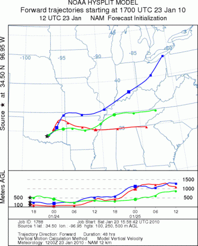
Trajectory Start (s) (shown by black
star on map): Davis, OK.
SATURDAY
SUNDAY
Prepared by: Estelle
Levetin
(Faculty
of Biological Science, The University of Tulsa, 800 S. Tucker Dr., Tulsa, OK 74104) and Peter
K Van de Water
(Department of Earth and Environmental Science, California State University Fresno, 2576 East San Ramon Avenue,
M/S ST24, Fresno CA 93740-8039). This forecast gives the anticipated future track of released Mountain Cedar pollen,
weather conditions over the region and along the forecast pathway, and an estimated time of arrival for various
metropolitan areas.
Questions: Aerobiology Lab e-mail: pollen@utulsa.edu
Return to Forecasting Home Page