The University of Tulsa
Mountain Cedar Pollen Forecast

Metropolitan Area |
Exposure Risk |
|
Oklahoma City |
Moderate |
|
Tulsa |
Low |
|
St. Louis MO |
Low |
Date Issued: 27 January 2010
Mountain Cedar Location(s): Arbuckle Mountains, OK
Regional Weather: Wednesday, January 27 TX/OK:
Cloudy skies will begin the day and build today and tomorrow with a significant chance of precipitation beginning
tonight and into tomorrow. This morning there is a chance of showers in most areas with foggy conditions this
morning and drizzle common. Temperatures will still climb into the 60s in most areas. In central Oklahoma highs
will reach into the mid 50s. Winds will be from the south today at moderate levels in Oklahoma and on the Edwards
Plateau. In the communities surrounding the Plateau winds will be from the southeast. Tonight cloudy skies will
remain with the chance of precipitation rising to levels greater than 50% in most areas, especially toward morning.
Temperatures will remain warm ahead of a cold front moving south out of the central plains. Temperatures overnight
will be in the mid to upper 50s in most places. On Thursday, cloudy skies will remain with with temperatures in
the upper 50s to low 60s across Texas. In Oklahoma temperatures will drop into the mid 30s to upper 40s. The
chance of showers and thunderstorms across the region will be in the 80% to 90% range. To the north freezing rain
and sleet is expected with a winter storm warming across the area. Winds to the north will switch from a southerly
direction to the northeast at moderate levels. Across Texas winds will continue from the south across the Edwards
Plateau at moderate conditions to the southeast in the surrounding communities. Thursday night precipitation continues
with a wintery mix across Oklahoma and temperatures across Texas dropping into the upper 30s. Areas to the west
will see winds from the north at moderate levels building overnight. In the eastern sections of the Plateau and
surrounding communities winds will start from the southeast and east then switch to a north to northwestern direction
and become gusty.
Trajectory weather: Cloudy skies and increasing humidity will occur across central and southern Oklahoma
today with a 20% chance of showers today building to a wintery mix overnight. Temperatures will be in the mid
50s to 60s today but as a cold front moves in they will drop into the 30s and 40s tonight. Pockets of freezing
rain and rain are expected. Winds will be from the south at moderate to strong levels today and shift to a southwesterly
direction overnight. Tomorrow, the chance of precipitation increases to 80% across the region as high temperatures
only reach into the upper 30s to lower 40s. Freezing rain, snow and sleet are expected. Winds will stay and moderate
to strong levels but switch from the south to a northeasterly direction. Tomorrow night the chance of precipitation
remains near 80% with temperatures down around 20 degrees and a strong northerly wind.
OUTLOOK: *** Low Threat today; Low threat tomorrow *** Low conditions for pollen
release today and Low conditions tomorrow; Low conditions for entrainment and transport today, Low conditions tomorrow.
Seasonal temperatures today but with deteriorating conditions and a chance of showers results in a low threat.
Winds will be from the south at moderate levels and the atmosphere is stable. However conditions are changing
towards the evening with a wintery mix on its way. Conditions may lead to some pollen dissemination with entrainment
and travel, but the winds will carry it towards the incoming poor weather conditions. Therefore the threat in
Oklahoma City remains moderate but rest of the region is low. Conditions will continue to degrade overnight and
into tomorrow with a significant chance of precipitation in the form of a wintery mix of sleet, snow and freezing
rain for Thursday. Similar conditions will occur Thursday night with temperatures well below freezing.
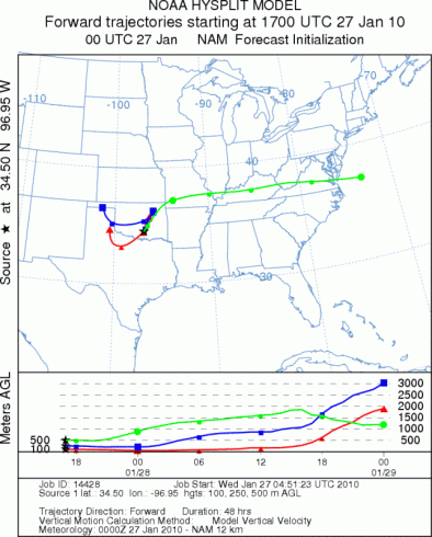
Trajectory Start (s) (shown by black
star on map): Davis, OK.
Prepared by: Estelle
Levetin
(Faculty
of Biological Science, The University of Tulsa, 800 S. Tucker Dr., Tulsa, OK 74104) and Peter
K Van de Water
(Department of Earth and Environmental Science, California State University Fresno, 2576 East San Ramon Avenue,
M/S ST24, Fresno CA 93740-8039). This forecast gives the anticipated future track of released Mountain Cedar pollen,
weather conditions over the region and along the forecast pathway, and an estimated time of arrival for various
metropolitan areas.
Questions: Aerobiology Lab e-mail: pollen@utulsa.edu
Return to Forecasting Home Page