
The University of Tulsa
Mountain Cedar Pollen Forecast
Metropolitan Area |
Exposure Risk |
|
Dallas/Fort Worth |
Low |
|
Austin |
Low |
|
San Antonio |
Low |
Date Issued: 28 January 2010
Mountain Cedar Location(s): Edwards Plateau, Texas
Regional Weather: Thursday, January 28 TX/OK:
Cloudy skies are in the forecast for the next couple of days. The region is under a severe winter storm watch
as wintery mix moves into the region with cold air from the north and moisture from the south. Sleet, snow, and
freezing rain are expected today and tomorrow across Oklahoma and areas of Texas. To the south with warmer conditions
thunderstorms and rain showers will occur. Temperatures will start in the 50s and 60s across Texas today but temperatures
will drop into the 30s and 40s as the cold air moves southward.. Across Oklahoma temperatures will begin in the
30s and 40s this morning and cool into the 20s tonight. Tomorrow highs will remain in the 20s and 30s with tomorrow
nights lows in the teens. There is a significant chance of precipitation across the region today, tonight and
especially towards the north tomorrow. Winds will begin from the south at moderate levels which will turn, coming
from the north, as the cold air moves in. Winds will maintain themselves from the northwest at moderate strength
with many areas experiencing gusty conditions.
Trajectory weather: Conditions today will be wet with colder conditions on their way overnight and for
tomorrow. Temperatures will be in the 60s but thunderstorms and showers are expected across the region with most
areas having a 90% to 100% chance of precipitation. Winds will initially be from the south but will shift overnight
to a northerly direction with colder conditions. Tomorrow cloudy conditions will prevail to the north and on the
Edwards Plateau but partly sunny conditions will occur in the areas surrounding the Plateau. Temperatures will
be in the upper 30s in most areas with warmer conditions in the communities surrounding the Plateau. The chance
of rain tomorrow will be primarily away from the Edwards Plateau and decreases from the south towards the north
during the afternoon. Tomorrow night will be mostly clear to partly cloudy and cold. Winds will be moderate to
strong from the north.
OUTLOOK: *** Low threat today; Low threat tomorrow *** Low conditions for pollen
release today and Low conditions tomorrow; Low conditions for entrainment and transport today, Low conditions tomorrow.
Temperatures today will be in the 50s and 60s with a significant chance of rain across the region. Winds will
be from the south and moderate in strength. Skies will be cloudy and little pollen release is expected today.
Tomorrow conditions will improve but temperatures will drop into the 30s and 40s thus creating conditions that
are unlikely to lead to pollen dissemination. Because of the conditions the threat today and tomorrow is low.
Conditions are poor for pollen release therefore entrainment and travel of pollen is not considered.
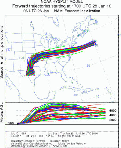
Trajectory Start (s) (shown by *
on map): Austin, TX; Junction, TX; Sonora, TX.
AUSTIN
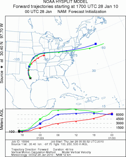
JUNCTION
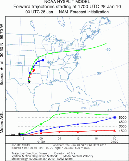
SONORA
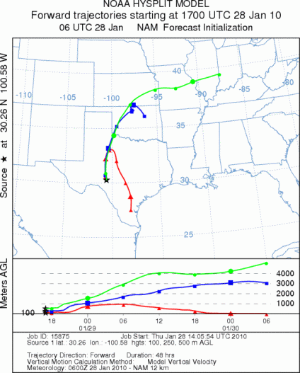
EDWARDS PLATEAU COMPOSITE
Prepared by: Estelle
Levetin (Faculty of Biological
Science, The
University of Tulsa, 800 S. Tucker Dr., Tulsa, OK 74104) and ) and Peter
K Van de Water (Department of Earth and Environmental Science, California State University Fresno,
2576 East San Ramon Avenue, M/S ST24, Fresno CA 93740-8039). This forecast gives the anticipated future track of
released Mountain Cedar pollen, weather conditions over the region and along the forecast pathway, and an estimated
time of arrival for various metropolitan areas.
Questions: Aerobiology Lab e-mail: pollen@utulsa.edu
Return to Forecasting Home Page