The University of Tulsa
Mountain Cedar Pollen Forecast

Metropolitan Area |
Exposure Risk |
|
Oklahoma City |
Low |
|
Tulsa |
Low |
|
St. Louis MO |
Low |
Date Issued: 29 January 2010
Mountain Cedar Location(s): Arbuckle Mountains, OK
Regional Weather: Friday, January 29 TX/OK:
Cloudy skies will remain for the next couple of days as the significant winter storm that occurred yesterday move
towards the east. Texas will continue to see high humidity and a chance of thunderstorms as moisture continues
to be across the region. Conditions will begin to dry out this afternoon heading into tomorrow.. Conditions in
Oklahoma will remain cold with wintery precipitation today and a winter storm warning into tonight. Tomorrow conditions
will begin to improve. Today there is increased chance of precipitation this morning across Texas especially across
the northern areas. Temperatures will climb into the 40s today and winds will be moderate to strong from the northwest.
In Oklahoma freezing rain, sleet, and snow will occur across the state with temperatures in the 20s and winds
from the north at moderate levels. Tonight temperatures will be in the teens and low twenties across Oklahoma
and the low to mid twenties across Oklahoma. Winds will remain moderate from the north across the region. Tomorrow
partly cloudy skies will begin the day with clear to partly sunny to clear conditions as the day wears on. Temperatures
will remain near or below freezing in Oklahoma and in the mid to upper 40s across Texas. Winds will remain moderate
from the north. Saturday night will be clear and cold region wide. Winds speeds will decline but maintain from
the north.
Trajectory weather: Cloudy skies and precipitation will occur across central and southern Oklahoma today
with a 100% chance of a wintery mix occurring across the region. Temperatures will be in the mid to upper 20s
today as the winter storm keeps moving east. Tonight temperatures will fall to the teens and lower 20s warming
only slightly tomorrow to near freezing conditions. Tomorrow night temperatures will drop back into the teens
and lower 20s. Winds will be from the north and strong this morning. As the weather system moves out of the region
winds will begin to drop becoming light and variable tomorrow and tomorrow night. Freezing rain, snow and sleet
are still expected today and tonight. Tomorrow the chance of precipitation begins to drop and partly cloudy skies
begin to return to the region.
OUTLOOK: *** Low threat today; Low threat tomorrow *** Low conditions for pollen release today and Low conditions
tomorrow; Low conditions for entrainment and transport today, Low conditions tomorrow. Cold conditions with
wintery precipitation will occur across Oklahoma today. Conditions will be poor for pollen dissemination thus
there is a low threat. Because of the poor conditions for release, little pollen is expected and conditions for
entrainment and travel will be a minor consideration Little pollen will be in the atmosphere in the next couple
of days.
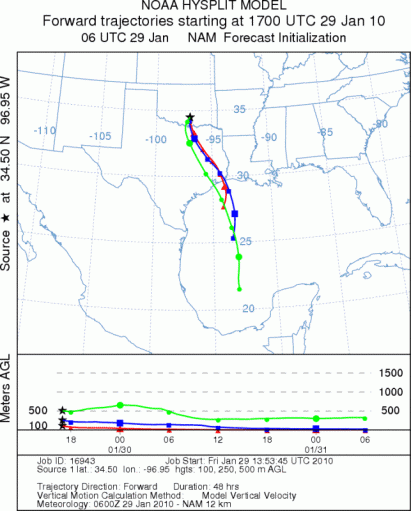
Trajectory Start (s) (shown by black
star on map): Davis, OK.
Prepared by: Estelle
Levetin
(Faculty
of Biological Science, The University of Tulsa, 800 S. Tucker Dr., Tulsa, OK 74104) and Peter
K Van de Water
(Department of Earth and Environmental Science, California State University Fresno, 2576 East San Ramon Avenue,
M/S ST24, Fresno CA 93740-8039). This forecast gives the anticipated future track of released Mountain Cedar pollen,
weather conditions over the region and along the forecast pathway, and an estimated time of arrival for various
metropolitan areas.
Questions: Aerobiology Lab e-mail: pollen@utulsa.edu
Return to Forecasting Home Page