
The University of Tulsa
Mountain Cedar Pollen Forecast
Metropolitan Area |
Exposure Risk |
|
Dallas/Fort Worth |
Low |
|
Austin |
High |
|
San Antonio |
High |
Date Issued: 1 January 2011
Mountain Cedar Location(s): Edwards Plateau, Texas
Regional Weather:
Saturday, January 1 - TX/OK:
The region today will be cool as a dominant northerly breeze brings colder air across Oklahoma and into Texas.
Todays temperatures will be moderate but tonight the region will be in the teens in Oklahoma and only approach
the above freezing mark in the other communities. Winds will be from the north and moderate across the region
today, then shift across Texas coming more from the east and northeast overnight. Regionally the skies will be
partly cloudy to partly sunny and dry. In Oklahoma todays high temperatures will get into the mid-30s to lower
40s with partly sunny skies and winds starting from the north becoming light and variable overnight. High temperatures
tomorrow will start to warm but only reach the mid-40s, but with sunny skies and light breezes out of the southeast.
Sunday night low temperatures are expected to remain cold with temperatures in the mid 20s. Across Texas Temperatures
today will mostly be in the 50s with the warmest spots just breaking into the low 60s along the southern edge of
the Edwards Plateau. Skies will be mostly sunny to partly cloudy and winds will be light to moderate from the
north. There is no predicted chance of precipitation through the forecast period. Tonight lows will be in the
upper 20s towards the west and lower 30s towards the east. Winds will be light and from the east region wide as
they begin to turn to a warmer more southerly direction. Tomorrow sunny skies will occur to the east with partly
cloudy conditions west. High temperatures range across the 50s to just reaching 60 in the San Antonio region.
The winds will continue to turn with light easterly moving toward southeasterly breezes will occur Sunday heading
into Sunday night. Into the evening skies will become partly cloudy with cold conditions returning into the 20s
and 30s. Low temperatures in the communities surrounding the eastern Edwards Plateau will be just above freezing
for the most part.
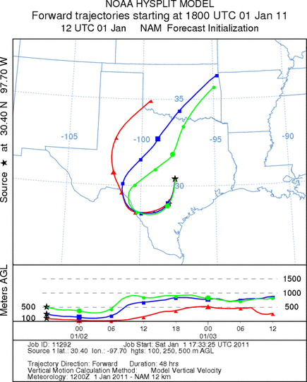
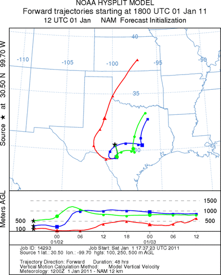
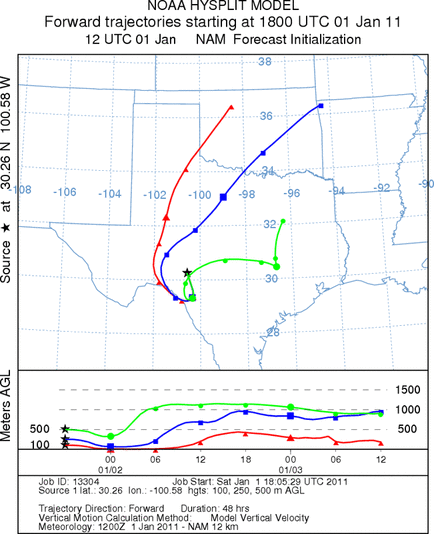
Trajectory weather: Air
mass trajectories from the Edwards Plateau move south then circle back towards the west and up over central Oklahoma
in the next 48 hours. This movement comes as regional winds switch from a predominantly northern flow to a predominant
southern flow moving towards coming from the southwest. Skies will be clearing from partly and mostly cloudy
to full sunshine in many areas today and tomorrow. Temperatures will be cool with highs only in the 50s today
and upper 50s tomorrow. Frigid conditions will occur both nights with temperatures near or below freezing. Winds
will be moderate today but falling off with the denser, heavier cold air. The cold air body will have little buoyancy
and thus the entrainment and travel potential of pollen that is release will be restricted. Cold conditions should
reduce significant pollen release both today and tomorrow. However conditions will be improving tomorrow and into
the week.
OUTLOOK: *** Moderate Threat today and ModerateThreat Tomorrow
*** Moderate conditions for pollen release today and Moderate
conditions tomorrow. Poor conditions for entrainment and transport exist today and Moderate for tomorrow. Today
will see mixed sky conditions ranging from partly cloudy to the west today and tomorrow to Sunny conditions to
the ast. Light to moderate winds both day but temperatures in the 50s both days. Overnight the region will see
temperatures near to below freezing. The trees are entering into the most active portion of their pollination
season however the overall cold conditions may restrain pollen release today and tomorrow. If pollen occurs the
generally heavy air and light winds should further hamper significant entrainment and travel, However, localized
heavy concentrations are not only likey but probable resulting in High concentrations. For these reasons we are
calling for moderate conditions and expect them to primarily occur within general Edwards Plateau area with little
long distance dispersal.
Trajectory Start (s) (shown by *
on map): Austin, TX; Junction, TX; Sonora, TX.
AUSTIN
JUNCTION
SONORA
EDWARDS PLATEAU COMPOSITE
Prepared by: Estelle
Levetin (Faculty of Biological
Science, The
University of Tulsa, 800 S. Tucker Dr., Tulsa, OK 74104) and ) and Peter
K Van de Water (Department of Earth and Environmental Science, California State University Fresno,
2576 East San Ramon Avenue, M/S ST24, Fresno CA 93740-8039). This forecast gives the anticipated future track of
released Mountain Cedar pollen, weather conditions over the region and along the forecast pathway, and an estimated
time of arrival for various metropolitan areas.
Questions: Aerobiology Lab e-mail: pollen@utulsa.edu
Return to Forecasting Home Page