
The University of Tulsa
Mountain Cedar Pollen Forecast
Metropolitan Area |
Exposure Risk |
|
Dallas/Fort Worth |
Moderate |
|
Austin |
High |
|
San Antonio |
High |
Date Issued: 3 January 2011
Mountain Cedar Location(s): Edwards Plateau, Texas
Regional Weather:Monday,
January 03 TX/OK:
The region today will be mild as warm southerly breezes blow across the region. Todays temperatures will be mild
and in the 50s to 60s then staying in the 40s and 50s tonight across Texas. In Oklahoma temperatures will dip
below freezing across most of Oklahoma. Clear skies across Oklahoma will be sunny today with high temperatures
in the southern portion of the state in the mid 50s. Winds will be from the south at 10 to 15 mph. Tonight cloudy
conditions begin to build from the south to partly cloudy levels with low temperatures in the mid- to lower 20s.
Winds will shift overnight from a southerly direction to coming out of the north. Winds will begin light and
variable but build overnight as another incursion of cold air heads towards the southern Great Plains. Tomorrow
temperatures will cool by about 10 degrees with highs expected in the mid 40s to 50. Winds will be from the northeast
and light declining to light and variable conditions Tuesday evening. In Texas mostly cloudy conditions will occur
along the eastern edge of the Edwards Plateau with temperatures warming into the 60s as southerly winds blow at
moderate levels. Winds will be increasing to moderate to strong levels this afternoon. The western side of the
Edwards Plateau will be partly cloudy. Overnight temperatures will be mild with lows in the 40s to the east and
30s to the west. Winds will begin to turn coming from the west overnight and eventually coming out of the north
on Tuesday. Conditions on Tuesday will become cloudier with drizzle and fog in the edge communities and a 20%
chance of showers during the afternoon. High temperatures will be in the low 60s across the area. Winds will
be moderate from the north. Overnight winds will once more turn to a southerly direction on the western side of
the Edwards Plateau. Temperatures will be mild, in the low 40s in most regions, dipping into the upper 30s in
the western most areas. A 20% chance of showers will continue overnight, Tuesday, along the eastern Edge Communities.
Trajectory weather: Air
mass trajectories from the Edwards Plateau move northward over the top of Texas today, then towards the south as
the overall wind field shifts from a northerly to a southerly direction. This movement comes as regional winds
switch from a predominantly southerly flow to a predominant northern flow by Tuesday. Skies will be partly cloudy
to cloudy conditions this afternoon and tomorrow with a chance of drizzle and fog along with a 20% chance of rain
in the eastern edge communities. Temperatures will be seasonal in the 50s to mid 60s today and tomorrow. Mild
conditions will occur both nights with temperatures in the 40s to 50s to the east and into the 30s out to the
west. Winds will be moderate today from the south, turning overnight to a westerly flow and then coming from the
north tomorrow and tomorrow night. The incursion of colder air from the west and north, tomorrow, will be dense
and have light winds behind it, so ground surface movement will be reduced and stay in the general Edwards Plateau
region.
OUTLOOK: *** Moderate Threat today and Moderate Threat Tomorrow*** Good conditions for pollen release today and Good conditions tomorrow.
Moderate conditions for entrainment and transport exist today and Moderate for tomorrow. Today and tomorrow sky
conditions will ranging from mostly cloudy to partly cloudy with seasonal temperatures in the 50s and 60s. Winds
will be light to moderate from the south today, but will switch overnight to a westerly flow and eventually to
a northerly flow. The surface air appears to be relatively dense and only moderate conditions for entrainment
and travel. Overnight the region will see temperatures near to below freezing. The trees are entering into the
most active portion of their pollination season. However, the overall cool conditions should retard pollen release.
It is expected that in communities in which a lot trees grow high levels can still be expected, but transport
out of the region will be limited. Increasingly good pollen release conditions are expected to occur today and
tomorrow, but entrainment and travel should be somewhat limited. Dense air and increasing humidity with the chance
of showers in the eastern Edwards Plateau region should further retard significant entrainment and travel on tonight
and tomorrow. For these reasons we are calling for good conditions building over Sunday and Monday and a high
threat of effects to occur in downwind communities.
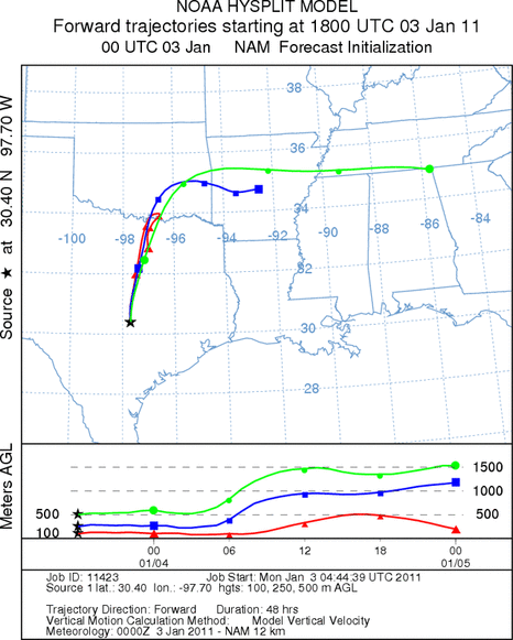
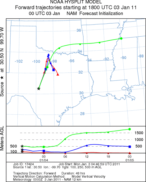
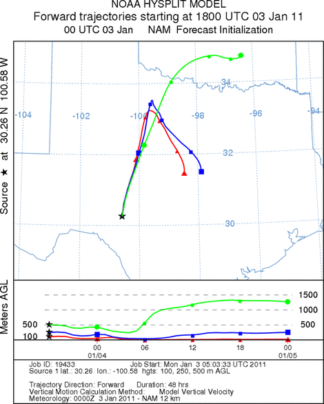
Trajectory Start (s) (shown by *
on map): Austin, TX; Junction, TX; Sonora, TX.
AUSTIN
JUNCTION
SONORA
EDWARDS PLATEAU COMPOSITE
Prepared by: Estelle
Levetin (Faculty of Biological
Science, The
University of Tulsa, 800 S. Tucker Dr., Tulsa, OK 74104) and ) and Peter
K Van de Water (Department of Earth and Environmental Science, California State University Fresno,
2576 East San Ramon Avenue, M/S ST24, Fresno CA 93740-8039). This forecast gives the anticipated future track of
released Mountain Cedar pollen, weather conditions over the region and along the forecast pathway, and an estimated
time of arrival for various metropolitan areas.
Questions: Aerobiology Lab e-mail: pollen@utulsa.edu
Return to Forecasting Home Page