
The University of Tulsa
Mountain Cedar Pollen Forecast
Metropolitan Area |
Exposure Risk |
|
Dallas/Fort Worth |
Low |
|
Austin |
Moderate |
|
San Antonio |
Moderate |
Date Issued: 5 January 2011
Mountain Cedar Location(s): Edwards Plateau, Texas
Regional Weather: Wednesday, January 05 TX/OK:
The region today will continue to be mild with light winds from the northwest and west settle over the area for
the next two days. Todays temperatures will be mild, in the 50s to 60s over Texas and Oklahoma, with low temperatures
in the 20s and 30s over the region. In Oklahoma daytime sunny skies and cool conditions will occur today with
high temperatures in the low 50s north and upper 50s along the border. Winds will be from the northwest and be
light reaching towards 10 miles per hour this morning then declining to light and variable conditions this afternoon
and tonight. Similar conditions will occur tomorrow. Temperatures will drop into the twenties north and low 30s
south, then warm into the mid 50s north and mid 60s south tomorrow. Tomorrow night temperatures will be in the
thirties. Light and variable winds are expected tomorrow. In Texas, todays conditions will see mostly cloudy
skies this morning along the eastern edge of the Edwards Plateau, with partly cloudy conditions further west.
The edge communities along the Edwards Plateau are expected to experience fog this morning. Temperatures will
be warming through the day into the 60s approaching 70 in the southernmost communities. Tonight partly cloudy
conditions will drop from the mid to low 30s into the mid to upper 20s. Winds will continue from the north to
northwest at light levels. Partly cloudy conditions will remain over the Edwards Plateau tomorrow with partial
clearing and sunny skies across Oklahoma southwards along the eastern edge of the Edwards Plateau. Temperatures
will return to the mid to upper 60s and light winds from the northwest. Thursday night partly cloudy skies will
return over the region with temperatures in the upper 20s to the west and mid 30s to the east. Winds will begin
to shift Thursday night however wind strength remain light.
Trajectory weather: Air mass trajectories from the Edwards Plateau move generally southeasterly over the
top of Texas today with light and variable winds over Texas. This movement comes as regional winds remain predominantly
northwesterly over the forecast period. Overall wind strength will be light and the air will be relatively dense
travelling at the ground. Skies will be partly cloudy to mostly cloudy conditions today, tonight, tomorrow and
tomorrow night. Tomorrow the edge communities can expect mostly sunny conditions. Temperatures will be cool but
warming slightly. High temperatures will be mostly in the 60s today with the southernmost communities approaching
70. Fog is expected along the eastern edge of the Edwards Plateau early today but burning off relatively quickly.
Tomorrow is expected to be slightly cooler by a few degrees than today. Cool conditions will occur both nights
with temperatures in the 20s to 30s tonight and tomorrow night. The most distinctive characteristic of the region
over the next two days will be the light mixed winds over the region and the dense air over the region that will
be moving along the ground. The trajectories show that over the next 48 hours winds blowing across the Edwards
Plateau, for the most part will be confined within the state boundaries and moving towards the southeast. Light
and variable winds can be expected over the forecast period. Because of these conditions, ground surface movement
and pollen entrainment will be reduced and stay in the general Edwards Plateau region.
OUTLOOK: *** Moderate Threat today and Moderate Threat Tomorrow*** Goodconditions
for pollen release today andGood conditions tomorrow. Poor conditions for entrainment and transport exist today
and tomorrow. Today and tomorrow sky conditions will be partly cloudy during the night but clearing to mostly sunny
conditions with seasonal temperatures in the 60s and approaching 70 in some areas. Tomorrow temperatures will
cool by 5 to 10 degrees in most areas. Winds will be light from the northeast today, and will calm tonight and
tomorrow to generally light and variable conditions. The surface air appears to be relatively dense and stable
creating poor conditions exist for entrainment and travel. Overnight the region will see temperatures in the 20s
and 30s. The trees are entering into the most active portion of their pollination season. However, the overall
calm conditions should retard pollen entrainment for any long distance travel. This does not mean that high levels
will not be encountered within the growing populations where release is ongoing. It is expected that in communities
in which a lot trees grow high levels can still be expected, but transport out of the region will be limited and
to the southeast. Good pollen release conditions are expected to occur today and tomorrow. Dense air and light
winds should further retard significant entrainment and travel today. For these reasons we are calling for a Moderate
threat today and tomorrow with the potential of pollen release but not significant travel downwind of the releasing
trees.
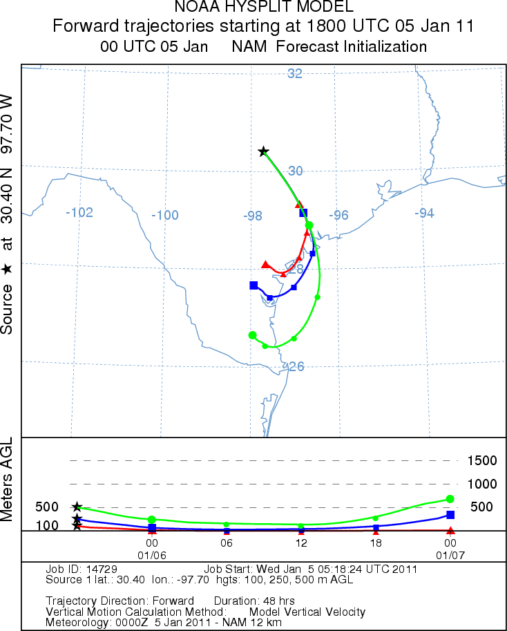
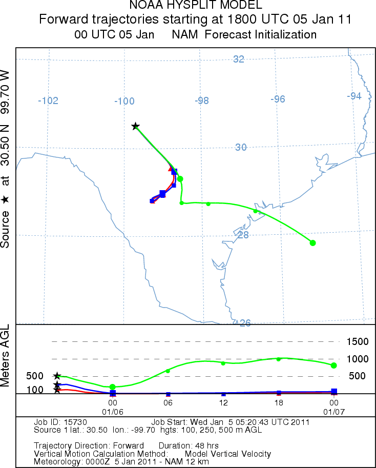
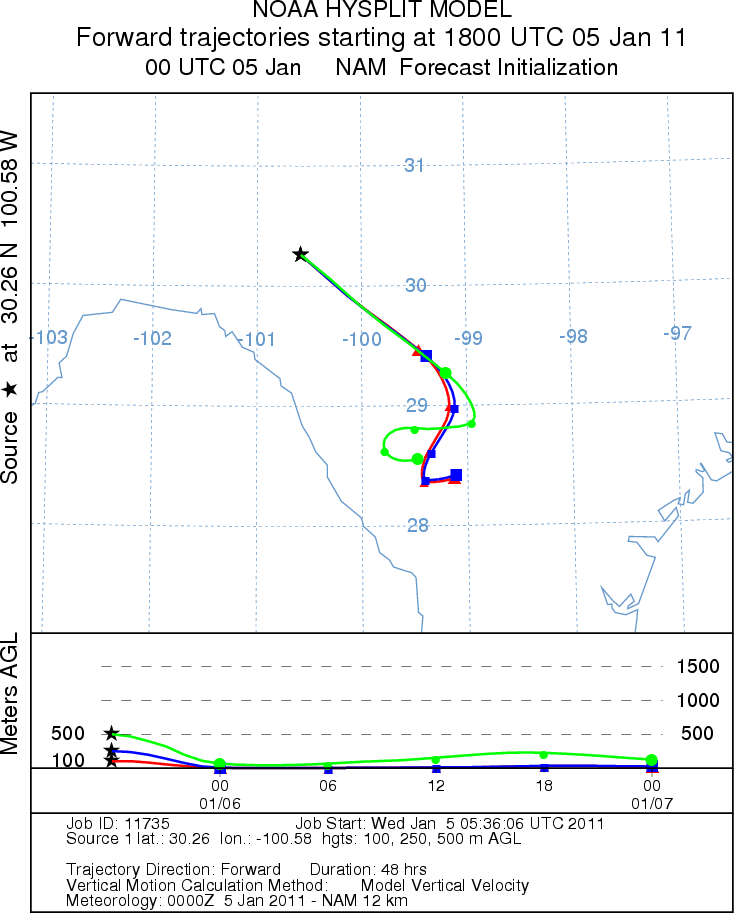
Trajectory Start (s) (shown by *
on map): Austin, TX; Junction, TX; Sonora, TX.
AUSTIN
JUNCTION
SONORA
EDWARDS PLATEAU COMPOSITE
Prepared by: Estelle
Levetin (Faculty of Biological
Science, The
University of Tulsa, 800 S. Tucker Dr., Tulsa, OK 74104) and ) and Peter
K Van de Water (Department of Earth and Environmental Science, California State University Fresno,
2576 East San Ramon Avenue, M/S ST24, Fresno CA 93740-8039). This forecast gives the anticipated future track of
released Mountain Cedar pollen, weather conditions over the region and along the forecast pathway, and an estimated
time of arrival for various metropolitan areas.
Questions: Aerobiology Lab e-mail: pollen@utulsa.edu
Return to Forecasting Home Page