
The University of Tulsa
Mountain Cedar Pollen Forecast
Metropolitan Area |
Exposure Risk |
|
Dallas/Fort Worth |
Moderate |
|
Austin |
Moderate |
|
San Antonio |
Moderate |
Date Issued: 7 January 2011
Mountain Cedar Location(s): Edwards Plateau, Texas
Regional Weather: Thursday, January 07 TX/OK:
The region today will continue to be mild with light winds from the northwest and west although the weather will
begin to deteriorate tomorrow towards the chance of rain across the area tomorrow night. Todays temperatures
will be mild, in the 50s to 60s over Texas and Oklahoma. Low temperatures will be in the 20s and 30s in Oklahoma
and 30s to 40s in Texas tonight. Tomorrow will bring cooler conditions north and south with a building chance
of precipitation during the afternoon into the evening. In Oklahoma daytime sunny skies and seasonal conditions
will occur today with high temperatures in the mid-50s north and mid 60s along the border. Winds will be from
the northwest and be light reaching towards 10 miles per hour this morning and afternoon. The winds return to
light and variable conditions this afternoon and tonight. Conditions tomorrow will cool by ten degrees and winds
will begin to move from the northwest to the northeast. Temperatures will drop into the 20s and 30s tonight,
then warm into the mid 50s to low 50s tomorrow. Tomorrow night there will be an increasing chance of rain with
lows in the mid 30s in the Arbuckle Mountains where the junipers grow. In Texas, todays conditions will see
mostly sunny skies with partly sunny and partly cloudy conditions over the plateau. Temperatures will be warming
through the day into the 60s approaching 70 in the southernmost communities. Tonight partly cloudy conditions
will give way to mostly cloudy conditions and temperatures will drop into the mid to low 30s over most of the
region. To the far west conditions my get below freezing. Winds will begin from the north to northwest at light
levels but will turn coming from the northeast overnight and gain some strength. Tomorrow there is an increasing
chance of showers and thunderstorms in the afternoon across the Edwards Plateau with the greatest chance occurring
around the eastern edge of the Plateau. Partly to mostly cloudy conditions will remain over the Edwards Plateau
tomorrow. Temperatures will cool to the 50s with the southern communities striving to get into the 60s. Winds
will be from the east shifting to the southeast heading into tomorrow night. There is a significant chance of
rain over the entire Edwards Plateau tomorrow night.
Trajectory weather: Air mass trajectories from the Edwards Plateau move generally eastward then southwestward
and westward over the top of Texas driven by light and variable winds. This movement comes as the regional winds
swing from a northwesterly direction this morning to northeasterly then easterly and eventually southeasterly over
the forecast period. Overall wind strength will be light and the air will be relatively dense travelling at or
near the ground. Skies will be mostly sunny to partly cloudy today but heavier clouds will move in tonight and
tomorrow as the chance of rain increases. The edge communities can expect mostly sunny conditions today and tomorrow
with partly cloudy conditions overnight. Temperatures will be seasonal both days with today being the warmest.
Tomorrow should cool be 10 degrees with most areas staying in the mid 50s. . Cool conditions will occur both
nights with temperatures in the 30s to 40s. Over the next two days winds will be the light mixed over the region
and the dense air that will be moving along the ground. Winds will increase generally from the northeast tomorrow
night as a significant chance of rain will occur across the area. The trajectories show that over the next 48
hours winds blowing across the Edwards Plateau, for the most part, will be confined within the state boundaries.
Light and variable winds can be expected over the forecast period. Because of these conditions, ground surface
movement and pollen entrainment will be reduced and stay in the general Edwards Plateau region.
OUTLOOK: *** Moderate Threat today and Moderate Threat Tomorrow*** Goodconditions
for pollen release today andGood conditions tomorrow. Poor conditions for entrainment and transport exist today
and tomorrow. Today and tomorrow sky conditions will be partly cloudy during the night but clearing to mostly sunny
conditions with seasonal temperatures in the 60s and approaching 70 in some areas today. Winds will be light
today and from the northeast tonight, then from the east tomorrow. The surface air continues to appear relatively
dense and stable creating poor conditions for entrainment and travel. Overnight the region will see temperatures
in the 30s and 40s. The trees are entering into the most active portion of their pollination season. However,
the overall calm conditions should retard pollen entrainment for any long distance travel. This does not mean
that high levels will not be encountered within the growing populations where release is ongoing. It is expected
that in communities in which a lot trees grow, high pollen levels can still be expected but transport out of the
region will be limited with trajectories flowing to the east and southeast. Good pollen release conditions are
expected to occur today and tomorrow. Dense air and light winds should further retard significant entrainment
and travel today. For these reasons we are calling for a Moderate threat today and tomorrow with the potential
of pollen release but not significant travel downwind of the releasing trees. Tomorrow during the day there will
be an increasing chance of showers and thunderstorms, especially across the Edwards Plateau. The increased humidity
and especially any precipitation will clear the air of airborne particles in those areas.
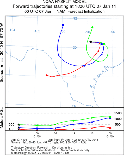
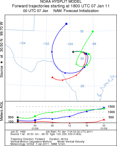
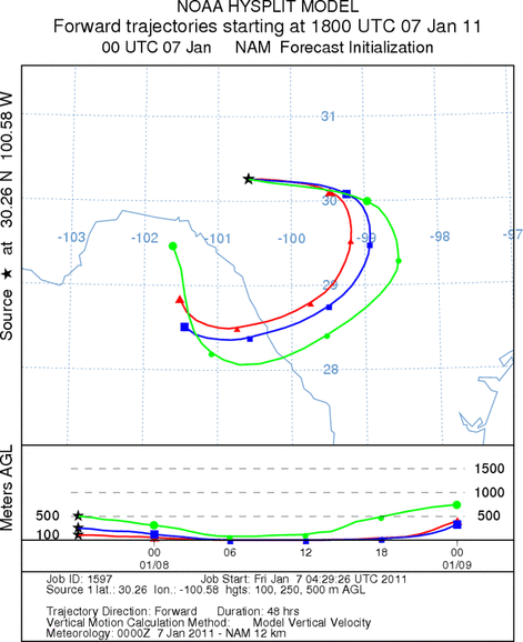
Trajectory Start (s) (shown by *
on map): Austin, TX; Junction, TX; Sonora, TX.
AUSTIN
JUNCTION
SONORA
EDWARDS PLATEAU COMPOSITE
Prepared by: Estelle
Levetin (Faculty of Biological
Science, The
University of Tulsa, 800 S. Tucker Dr., Tulsa, OK 74104) and ) and Peter
K Van de Water (Department of Earth and Environmental Science, California State University Fresno,
2576 East San Ramon Avenue, M/S ST24, Fresno CA 93740-8039). This forecast gives the anticipated future track of
released Mountain Cedar pollen, weather conditions over the region and along the forecast pathway, and an estimated
time of arrival for various metropolitan areas.
Questions: Aerobiology Lab e-mail: pollen@utulsa.edu
Return to Forecasting Home Page