The University of Tulsa
Mountain Cedar Pollen Forecast

Metropolitan Area |
Exposure Risk |
|
Oklahoma City |
Low |
|
Tulsa |
Low |
|
St. Louis MO |
Low |
Date Issued: 8 January 2011
Mountain Cedar Location(s): Arbuckle Mountains, OK
Regional Weather: Saturday, January 08 TX/OK:
The region today will see weather deteriorate towards rain tonight. Temperatures will be cooling dramatically
with a chance of snow and accumulation in northern Texas and southern Oklahoma. Todays temperatures will be seasonal,
in the 50s to 60s over the Texas and Oklahoma juniper populations. Low temperatures will be in the 20s and 30s
in Oklahoma and 30s to 40s in Texas tonight. There is a significant chance of rain this afternoon and tonight.
Tomorrow temperatures will be cooler with the chance of rain in the morning. In Oklahoma today partly cloudy
and cloudy skies will occur across central and southern Oklahoma. High temperatures will be in the upper 40s,
north, and lower 50s south, where the juniper populations grow. Winds will be from the northeast at mild conditions.
This afternoon and into the evening, the weather will deteriorate with rain expected after midnight. Winds will
start light but pickup through the night coming from the east. Tomorrow morning cloudy skies will prevail with
a continuing chance of rain and snow and temperatures in the mid-30s. Winds will have moved, coming from the southeast
to the area. Sunday night will continue with cloudy conditions and the chance of snow with temperatures in mid-
to upper 20s. In Texas, todays conditions will begin with mostly sunny skies to the north and along the Edwards
Plateau. The coming cloudy skies and rainy conditions will first occur to the west on the Edwards Plateau where
this afternoon there is a 20% chance of precipitation. Temperatures today will be in the upper 50s to low and
mid-60s. Winds for the most part will be from the east starting light but gaining in strength through the afternoon
as rain clouds build. Tonight most areas will experience rain with temperatures in the upper 30s to low 40s.
Winds will remain from the east. Tomorrow, precipitation will continue in the morning with colder conditions
across the region. High temperatures will be in the mid 30s in the Dallas region then rising only into the low
50s in the southern areas of the Edwards Plateau. A chance of rain exists for all regions. Winds will remain
from the northeast, southeast at the western most locations, and with moderate strength. There will be a chance
of snow accumulation from the Dallas region northward on Sunday and Sunday night. Overnight on Sunday temperatures
will remain in the mid- to low 30s across the area.
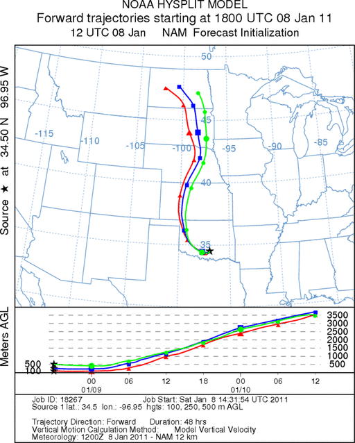
Trajectory weather: Air mass trajectories from the Arbuckle Mountains move initially westward on east winds,
then are picked up by large scale atmospheric movement and is taken northward over western Oklahoma and into the
upper midwest. Temperatures will only be in the low 50s today in southern Oklahoma then cool into the upper 20s
tonight. Cool conditions overnight will remain with tomorrows highs only expected to be in the mid 30s. The
trajectories show that the air is heavy and cool with little buoyancy initially before it is caught up in the wind
fields further north.. Skies will be partly cloudy to cloudy throughout the forecast period, with an increase
in moisture and the possibility of precipitation tonight and tomorrow. expects rain to move through. Cool conditions
will occur both nights with temperatures in the 20s and low 30s .
OUTLOOK: *** Moderate Threat today and Low Threat Tomorrow
*** mixed conditions for pollen release today and poor conditions tomorrow. Poor conditions for entrainment
and transport exist today and tomorrow. Cloudy conditions with light winds and temperatures in the mid 50s today
then cooling into the mid 30s tomorrow occur across the Oklahoma tree population. Winds on both days will be
moderate to light and variable. Conditions for pollination is expected to be good this morning but deteriorating
and then cold tomorrow that should result in pollen release being restricted. However, light winds and heavy air
moving along the ground will keep entrainment and travel at a minimum, and thus little entrainment and travel is
expected. For these reasons there is a moderate threat of pollen release today but the other conditions will either
be poor this morning and/or deteriorate during the day. Tomorrow conditions will continue to be deteriorate to
cold and potentially wet conditions with the chance of rain showers and snow tonight through tomorrow.
Trajectory Start (s) (shown by black
star on map): Davis, OK.
Prepared by: Estelle
Levetin
(Faculty
of Biological Science, The University of Tulsa, 800 S. Tucker Dr., Tulsa, OK 74104) and Peter
K Van de Water
(Department of Earth and Environmental Science, California State University Fresno, 2576 East San Ramon Avenue,
M/S ST24, Fresno CA 93740-8039). This forecast gives the anticipated future track of released Mountain Cedar pollen,
weather conditions over the region and along the forecast pathway, and an estimated time of arrival for various
metropolitan areas.
Questions: Aerobiology Lab e-mail: pollen@utulsa.edu
Return to Forecasting Home Page