
The University of Tulsa
Mountain Cedar Pollen Forecast
Metropolitan Area |
Exposure Risk |
|
Dallas/Fort Worth |
Low |
|
Austin |
Moderate to High |
|
San Antonio |
Moderate to High |
Date Issued: 8 January 2011
Mountain Cedar Location(s): Edwards Plateau, Texas
Regional Weather: Friday, January 08 TX/OK:
The region today will see weather deteriorate towards rain tonight. Temperatures will be cooling dramatically
with a chance of snow and accumulation in northern Texas and southern Oklahoma. Todays temperatures will be seasonal,
in the 50s to 60s over the Texas and Oklahoma juniper populations. Low temperatures will be in the 20s and 30s
in Oklahoma and 30s to 40s in Texas tonight. There is a significant chance of rain this afternoon and tonight.
Tomorrow temperatures will be cooler with the chance of rain in the morning. In Oklahoma today partly cloudy
and cloudy skies will occur across central and southern Oklahoma. High temperatures will be in the upper 40s,
north, and lower 50s south, where the juniper populations grow. Winds will be from the northeast at mild conditions.
This afternoon and into the evening, the weather will deteriorate with rain expected after midnight. Winds will
start light but pickup through the night coming from the east. Tomorrow morning cloudy skies will prevail with
a continuing chance of rain and snow and temperatures in the mid-30s. Winds will have moved, coming from the southeast
to the area. Sunday night will continue with cloudy conditions and the chance of snow with temperatures in mid-
to upper 20s. In Texas, todays conditions will begin with mostly sunny skies to the north and along the Edwards
Plateau. The coming cloudy skies and rainy conditions will first occur to the west on the Edwards Plateau where
this afternoon there is a 20% chance of precipitation. Temperatures today will be in the upper 50s to low and
mid-60s. Winds for the most part will be from the east starting light but gaining in strength through the afternoon
as rain clouds build. Tonight most areas will experience rain with temperatures in the upper 30s to low 40s.
Winds will remain from the east. Tomorrow, precipitation will continue in the morning with colder conditions
across the region. High temperatures will be in the mid 30s in the Dallas region then rising only into the low
50s in the southern areas of the Edwards Plateau. A chance of rain exists for all regions. Winds will remain
from the northeast, southeast at the western most locations, and with moderate strength. There will be a chance
of snow accumulation from the Dallas region northward on Sunday and Sunday night. Overnight on Sunday temperatures
will remain in the mid- to low 30s across the area.
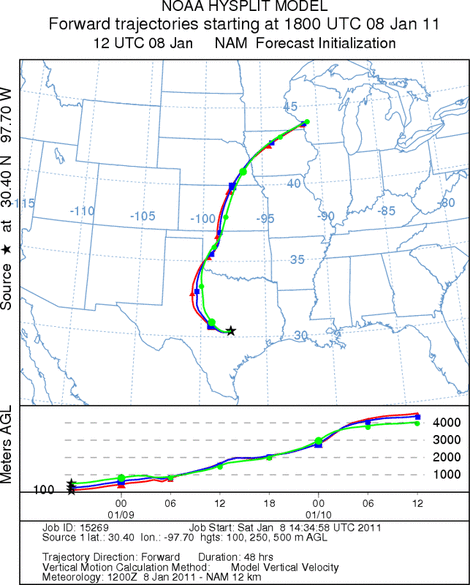
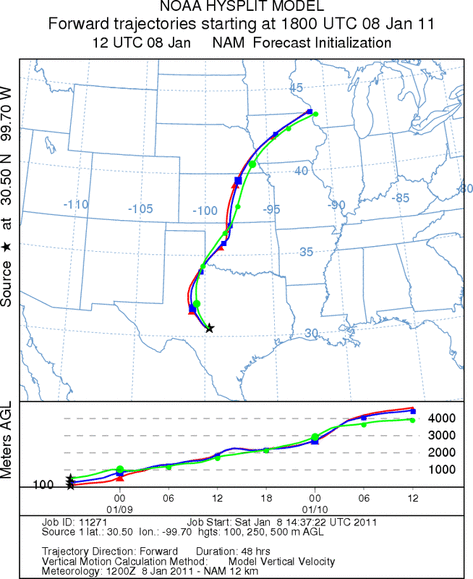
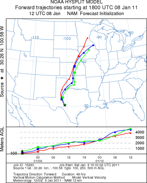
Trajectory weather: Air mass trajectories from the Edwards Plateau move generally westward then get caught
in larger scale atmospheric movements and moves towards the north crossing westernmost Oklahoma before moving into
the upper Midwest. Skies will be mostly sunny along the eastern Edwards Plateau this morning but will give way
early today to increasing clouds as the chance of rain moves into the region. High temperatures will be in the
mid 50s to low 60s today then decrease into the lower 50s in the warmest portion of the region tomorrow. The
chance of rain will begin this afternoon in the western most regions of the Edwards Plateau then move eastward.
There is a significant chance of rain across the region tonight. The edge communities can expect lingering
showers in most areas tomorrow throughout the morning and early afternoon. Over the next two days winds over the
Plateau will be moderate over the region and mostly from the east, starting from the northeast and sliding eventually
from the southeast. The trajectories generally move initially towards the west but are rapidly caught in the larger
scale movement in the atmosphere and head north over west Texas and western Oklahoma. Because of these conditions,
ground surface movement of pollen along with entrainment will be reduced and little is expected to move downwind
during these rainy conditions.
OUTLOOK: *** Moderate to High Threat Today
and Low Threat Tomorrow*** moderate conditions for pollen release today and
Poor conditions tomorrow. Poor conditions for entrainment and transport exist today and tomorrow. Today and tomorrow
sky conditions will be deteriorating as rain moves through the area. Temperatures will be in the 60s in most
areas today but approaching stormy conditions will not allow those temperatures to remain for long. Winds will
be moderate today and tomorrow from the northeast. Tomorrows temperatures will strive to get out of the 40s into
the low 50s in most areas. The surface air continues to appear relatively dense and stable creating poor conditions
for entrainment and travel. Overnight the region will see temperatures in the 30s and 40s, cooling significantly
tomorrow night. The trees are in their most active portion of their pollination season. However, the overall
poor conditions should retard pollen release along with entrainment for any long distance travel. This does not
mean that some pollen will not be encountered within the growing populations where release is ongoing. Marginal
pollen release conditions are expected to occur today prior to the rains moving in. For these reasons we are calling
for a Moderate threat today and low threat tomorrow. The increased humidity and especially any precipitation will
clear the air of airborne particles in those areas.
Trajectory Start (s) (shown by *
on map): Austin, TX; Junction, TX; Sonora, TX.
AUSTIN
JUNCTION
SONORA
EDWARDS PLATEAU COMPOSITE
Prepared by: Estelle
Levetin (Faculty of Biological
Science, The
University of Tulsa, 800 S. Tucker Dr., Tulsa, OK 74104) and ) and Peter
K Van de Water (Department of Earth and Environmental Science, California State University Fresno,
2576 East San Ramon Avenue, M/S ST24, Fresno CA 93740-8039). This forecast gives the anticipated future track of
released Mountain Cedar pollen, weather conditions over the region and along the forecast pathway, and an estimated
time of arrival for various metropolitan areas.
Questions: Aerobiology Lab e-mail: pollen@utulsa.edu
Return to Forecasting Home Page