
The University of Tulsa
Mountain Cedar Pollen Forecast
Metropolitan Area |
Exposure Risk |
|
Dallas/Fort Worth |
Low |
|
Austin |
Low |
|
San Antonio |
Low |
Date Issued: 9 January 2011
Mountain Cedar Location(s): Edwards Plateau, Texas
Regional Weather: Sunday, January 09 TX/OK:
The region today will start improving from last nights rain with cold conditions and snow continuing in northern
Texas and across Oklahoma. Rain showers and thunderstorms will continue this morning but start to taper off with
cool air and cloudy skies remaining. In Oklahoma, a wintery mix of rain and snow will occur this morning with
the temperatures in the 20s and 30s. Winds will be from the east at low to moderate levels. The chance of precipitation
will continue into tonight with temperatures remaining much the same. Tomorrow a chance of continued snow showers
or frozen drizzle remains in the forecast, with temperatures in the 30s and winds from the southeast. Tomorrow
night a chance of snow remains with very cold temperatures in the mid-teens. Winds will be primarily from the
north at moderate levels. In Texas, the temperatures will be warmer today with most areas in the 40s and 50s,
rain will begin to diminish. However, the edge communities will see showers continuing through this morning. Winds
will be from the east to north-east as this system moves away into eastern Texas. Temperatures will be in the
40s to upper 50s across the Edwards Plateau and much cooler northward towards Oklahoma. Dallas is expected to
get snow today. Tonight temperatures will be in the 30s with a moderate northeasterly breeze and cloudy to mostly
cloudy skies. Tomorrow the region will begin to warm with high temperatures getting into the upper 50s and fog
developing early, especially in the communities surrounding the eastern edge of the Edwards Plateau. In most regions
winds will be light and from a more southerly direction. The western areas of the Edwards Plateau will have winds
from the west and southwest whereas the eastern portion of the Plateau will still be under southeast to northeast
flow. Tomorrow night temperatures drop to the 20s with partly cloudy skies to the west and the low 30s with
mostly cloudy skies to the east. Winds will return to a northeasterly direction and be moderate and breezy across
the area.
Trajectory weather: Air mass trajectories from the Edwards Plateau are split with the development of stormy
conditions last night. To the east most of the area is still influenced by northeasterly breezes that will be
moderate and move the atmosphere towards the south, whereas on the western side of the plateau southerly breezes
move the atmosphere towards the north. Across the region this will cause the trajectories to rotate with the eventual
incursion of an overall northerly push of cold air tomorrow afternoon and evening. Today, precipitation will be
tapering off as the system that moved through last night continues to head towards the east. Temperatures today
will be in the low to mid-50s and conditions should be relatively wet from last nights precipitation. Cold
conditions will continue in north Texas as Dallas continues to have a chance of snow into this evening. Tonight
temperatures will be in the 30s across the region with winds from the northeast to southeast from the eastern
Plateau heading west. Tomorrow will continue to be cloudy but temperatures will begin to warm on southerly breezes
over the Plateau. The region will begin to dry. Tomorrow night skies will begin and temperatures will be around
freezing and below as cold air moves in from the north.
OUTLOOK: *** Low Threat today and Moderate Threat Tomorrow***
Poor conditions for pollen release today andmoderate conditions tomorrow. Poor conditions for entrainment
and transport exist today and moderate conditions tomorrow. Today and tomorrow conditions will be recovering from
the rain that moved through the area. Temperatures will be in the mid to low 50s today and upper 50s tomorrow.
The rain last night will continue into this morning especially along the eastern edge of the Edwards Plateau.
To the west mostly cloudy conditions will occur. Winds will be swirling over Texas as the system moves through
the state and heads east, therefore trajectories to the west will move northwards whereas those to the east will
move southward. Wet conditions and cool temperatures will create poor conditions for pollen release as well as
entrainment and travel today. Cold conditions will take over tonight with moderate winds. Tomorrow conditions
will improve, especially if drying conditions advance along with moderate winds in most regions. Tomorrow night
will return to cold conditions with many areas below freezing. The trees are in their most active portion of
their pollination season. The overall poor conditions should retard pollen release along with entrainment for
any long distance travel today. However, tomorrow marginal pollen release conditions are expected to occur although
it might be limited as the conditions develop. For these reasons we are calling for a low threat today and moderate
threat tomorrow. The increased humidity and especially any precipitation last night and today will clear the air
of airborne particles throughout the area
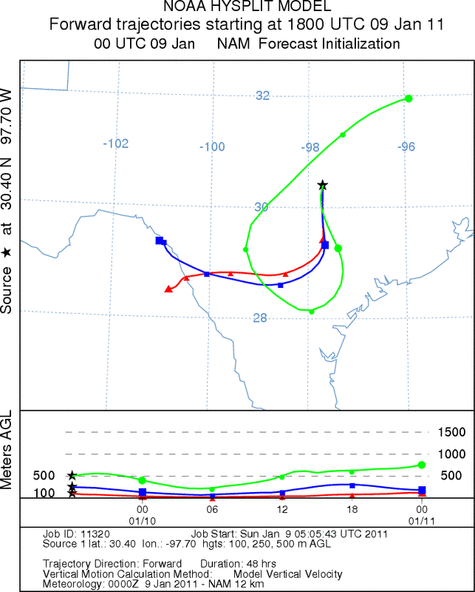
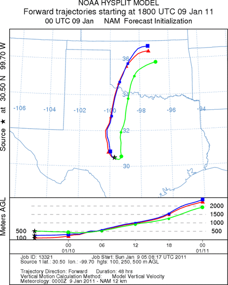
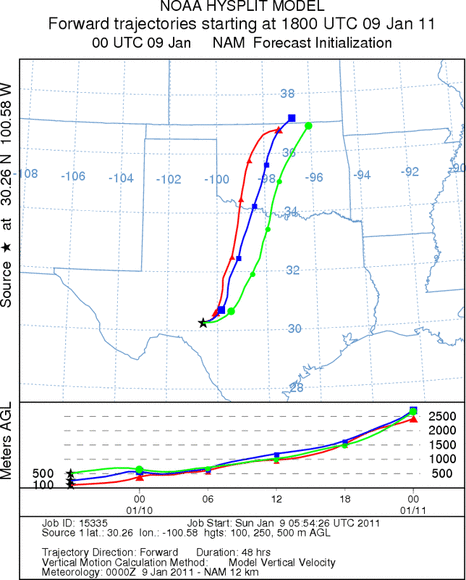
Trajectory Start (s) (shown by *
on map): Austin, TX; Junction, TX; Sonora, TX.
AUSTIN
JUNCTION
SONORA
EDWARDS PLATEAU COMPOSITE
Prepared by: Estelle
Levetin (Faculty of Biological
Science, The
University of Tulsa, 800 S. Tucker Dr., Tulsa, OK 74104) and ) and Peter
K Van de Water (Department of Earth and Environmental Science, California State University Fresno,
2576 East San Ramon Avenue, M/S ST24, Fresno CA 93740-8039). This forecast gives the anticipated future track of
released Mountain Cedar pollen, weather conditions over the region and along the forecast pathway, and an estimated
time of arrival for various metropolitan areas.
Questions: Aerobiology Lab e-mail: pollen@utulsa.edu
Return to Forecasting Home Page