
The University of Tulsa
Mountain Cedar Pollen Forecast
Metropolitan Area |
Exposure Risk |
|
Dallas/Fort Worth |
Low |
|
Austin |
Moderate to High |
|
San Antonio |
Moderate to High |
Date Issued: 10 January 2011
Mountain Cedar Location(s): Edwards Plateau, Texas
Regional Weather: Monday, January 10 TX/OK:
The region today will begin to dry out as the wet weather moves off to the east. Behind the cold wet weather, however,
there will be a day of seasonal temperatures and then cold air will move in from the north plunging daytime temperatures
tomorrow into the 30s for high temperatures. In Oklahoma this morning a wintery mix of rain and snow will occur
again today with snow expected in Oklahoma City and the chance of freezing drizzle south along the border with
Texas. Skies will be cloudy and high temperatures will stay in the 30s. Winds will be from the east at light
to moderate levels. Tonight there will be a 20% chance of snow with temperatures in the mid- to low teens. Winds
will be from the north to northwest at moderate levels. Those northerly breezes will bring cold air in across
the region with tomorrows high temperatures expected in the 20s to low 30s and winds picking up to moderate
conditions, reaching upwards of 20 miles per hour in some locations. Tomorrow night will continue to be cold with
low temperatures expected in the single digits. In Texas, warmer conditions will prevail today with this morning
seeing a significant chance of fog in most areas. On the eastern side of the Edwards Plateau some sun will peak
out between the clouds this morning but clouds will build over the afternoon and into the evening. Temperatures
today are expected to be in the 50s and lower 60s in most areas. Winds will predominate in this region from
the east moving colder air from the system that recently passed over Texas back toward the state. On the western
side of the Edwards Plateau mixed cloud cover will predominate. Winds will be from the southwest and west bringing
slightly warmer and dry conditions to the area. Overnight the east-west dichotomy will remain with partly cloudy
conditions west and temperatures in the low to mid 20s whereas to the east partly cloudy to mostly cloudy skies
will occur and temperatures will be in the upper 20s to lower 30s. Winds across the region will shift, coming
from the north with cold air. On Tuesday, this shift in the winds will be seen with high temperatures barely getting
into the 40s. Sky conditions will be much more broken up with sunny conditions to partly cloudy conditions across
the area. Winds will be moderate to strong from the north. Tomorrow night partly cloudy skies will return with
temperatures well into the teens in most areas. Winds will calm but remain primarily from a north to northeast
direction.
Trajectory weather: Air mass trajectories from the Edwards Plateau are mixed with the day beginning with
easterly winds on the eastern side of the Edwards Plateau and southwesterly and westerlys out to the west. Over
the next 48 hours, however winds will move predominantly to the south over southern Texas as cold air moves in
from the north. Temperatures today will be cool but seasonal with most many areas remaining in the 50s for their
high. The regions to the west will move into the low 60s. Tonight colder air infiltrates into the region and
low temperatures will be below freezing and mostly in the 20s. The cold air will continue tomorrow although skies
will lighten with partly cloudy to sunny conditions. High temperatures will, however, only be in the 30s in most
places with the Edwards Plateau edge communities creeping over the 40 degree mark. Winds will be moderate to strong
and from the north to northeast throughout the day and overnight. Tomorrow night temperatures will fall well below
freezing into the low teens and low twenties.
OUTLOOK: *** Moderate Threat today and Low Threat Tomorrow***
Moderate conditions for pollen release today andModerate conditions tomorrow. Moderate conditions for entrainment
and transport exist today and moderate conditions tomorrow. Today conditions will be recovering from the rain that
moved through the area. Temperatures will be in the mid to upper 50s today then become much colder as cold air
moves in from the north for tonight and tomorrow. The rain over the last couple of days will result in foggy conditions
this morning, but temperatures will rise into the 50s and just reach the 60s in the more southern locations.
Tomorrow and tomorrow night will see dominant winds from the north and cold conditions with Tuesdays highs expected
to barely reach 40 degrees. Tuesday night temperatures will be entrenched in the 20s and teens. Damp conditions
and cooler temperatures will create moderate conditions for pollen release today although the atmosphere is buoyant
and will create good conditions for entrainment and travel. Cold conditions will take over tonight with moderate
winds from the north for tomorrow. If drying conditions advance along with moderate winds in most regions today
some significant pollen release can be expected. This is especially true in the communities that have healthy
populations of the trees within the urban environment. For these reasons we have a moderate threat today, but
high to very high levels may be present within the populations themselves especially in the southern areas of the
trees distribution. Tomorrow will return to cold conditions with most areas below freezing overnight and barely
getting into the 40s on Tuesday. The trees are in their most active portion of their pollination season. The
overall cold conditions Monday night and Tuesday should retard pollen release. We have historically found a significant
drop off in pollen levels at these temperatures. For these reasons we are calling for a moderate threat today
and low threat tomorrow. Today will be the best chance for significant pollen release but then cold conditions
will reduce the chance tomorrow.
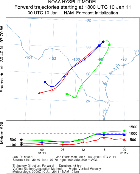
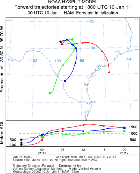
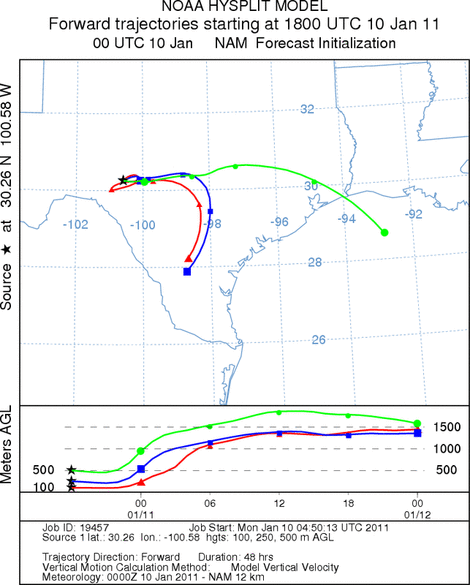
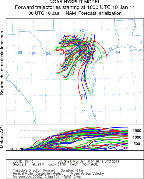
Trajectory Start (s) (shown by *
on map): Austin, TX; Junction, TX; Sonora, TX.
AUSTIN
JUNCTION
SONORA
EDWARDS PLATEAU COMPOSITE
Prepared by: Estelle
Levetin (Faculty of Biological
Science, The
University of Tulsa, 800 S. Tucker Dr., Tulsa, OK 74104) and ) and Peter
K Van de Water (Department of Earth and Environmental Science, California State University Fresno,
2576 East San Ramon Avenue, M/S ST24, Fresno CA 93740-8039). This forecast gives the anticipated future track of
released Mountain Cedar pollen, weather conditions over the region and along the forecast pathway, and an estimated
time of arrival for various metropolitan areas.
Questions: Aerobiology Lab e-mail: pollen@utulsa.edu
Return to Forecasting Home Page