
The University of Tulsa
Mountain Cedar Pollen Forecast
Metropolitan Area |
Exposure Risk |
|
Dallas/Fort Worth |
Low |
|
Austin |
Low to Moderate |
|
San Antonio |
Low to Moderate |
Date Issued: 11 January 2011
Mountain Cedar Location(s): Edwards Plateau, Texas
Regional Weather: Tuesday, January 11 TX/OK:
The region today will be cold as a push of cold air from the north takes over. Temperatures today from Oklahoma
to south Texas will feel the grip of the cold air. In Oklahoma this morning sunny skies will prevail but with
temperatures in the 20s in the central portion of the state to 30s southward along the border. Winds will be moderate
to gusty in some areas from the north and northwest. Tonight partly cloudy skies will return with the lows in
the low teens to single digits. Winds will remain from the north but lighten to light and variable conditions.
Tomorrow the partly cloudy skies will remain with high temperatures only reaching the upper 20s to mid-30s in
central and southern portions of the state. Tomorrow night will be clear with light a variable winds and temperatures
in the teens. In Texas, partly cloudy conditions will prevail over the Edwards Plateau with sunny and mostly sunny
skies to the east in the edge communities. High temperatures will mostly be in the 30s with some areas along the
edge, especially the southern urban areas, just making it into the 40s. Winds will be moderate from the northeast
with some gusts at greater strength. Tonight partly cloudy conditions move in with areas along the edge of the
plateau becoming mostly cloudy. Temperatures will be well below freezing in all communities with tees to the west
and mid to lower 20s in the edge communities. Winds will maintain themselves from the north to northeast at light
to moderate levels. Tomorrow will see the return of clear skies along with partly cloudy conditions, especially
to the west. High temperatures will again be stationed in the 30s with some of the southernmost communities barely
getting into the 40s. Winds will be light to moderate from the east and northeast. Tomorrow night the skies will
clear and temperatures will be near freezing and below across the region.
Trajectory weather: Air mass trajectories from the Edwards Plateau are mixed. With cold air settled over
the region today and into tomorrow winds will maintain themselves from the northeast to east. Skies will be mostly
sunny along the eastern edge of the Edwards Plateau and partly cloudy west of that region. High temperatures today
will barely get into the upper 30s in most areas with the southern and southeastern most zone of the Edwards Plateau
reaching into the low 40s. Winds will be moderate with some gustiness at greater wind strengths along the eastern
edge communities. Tonight temperatures will fall into the 20s and teens across the area. Tomorrow the area will
return to similar conditions in terms of high temperatures although the winds are expected to decrease and become
more moderate. Low temperatures tomorrow night will be mostly below freezing but stay in the 20s in most areas.
OUTLOOK: *** Low Threat today and Low Threat Tomorrow*** Poor conditions for pollen
release today and poor conditions tomorrow. Moderate conditions for entrainment and transport exist today and
moderate conditions tomorrow. Today conditions will be driven by the very cold temperatures that have settled
over the region. Temperatures will be in the mid to upper 30s today and tomorrow. Historically, we have found
a significant reduction in pollen entrained in the atmosphere at temperatures less than the mid- to upper 40s.
However, the trees should be near their peak of release and so with sunny skies some pollen may make it out.
If so, the atmosphere is buoyant and today is expected to be breezy, so entrainment and travel may occur. Tomorrow
and tomorrow night will be similar with winds from the north and cold conditions. Wednesdays highs are expected
to barely reach 40 degrees again. Wednesday night, temperatures will be entrenched in the 20s and low 30s.
Cold temperatures will create poor conditions for pollen release today although the atmosphere is buoyant and will
create moderate conditions for entrainment and travel towards the south. Cold conditions will continue tonight
and tomorrow with moderating winds from the north tomorrow and tomorrow night. For these reasons we have a poor
threat today, but some isolated pollen release may be present within local populations themselves especially in
the southern areas of the trees distribution. The trees are in their most active portion of their pollination
season. The overall cold conditions tonight and Wednesday should retard pollen release. We have historically
found a significant drop off in pollen levels at these temperatures. For these reasons we are calling for a low
threat today and low threat tomorrow.
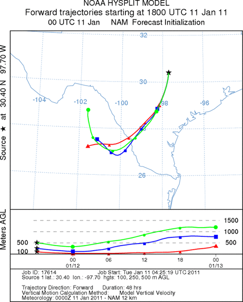
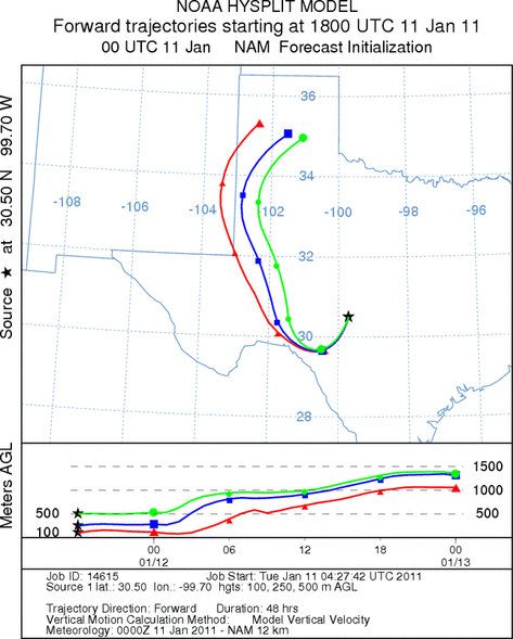
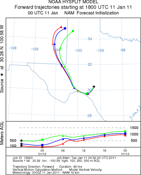
Trajectory Start (s) (shown by *
on map): Austin, TX; Junction, TX; Sonora, TX.
AUSTIN
JUNCTION
SONORA
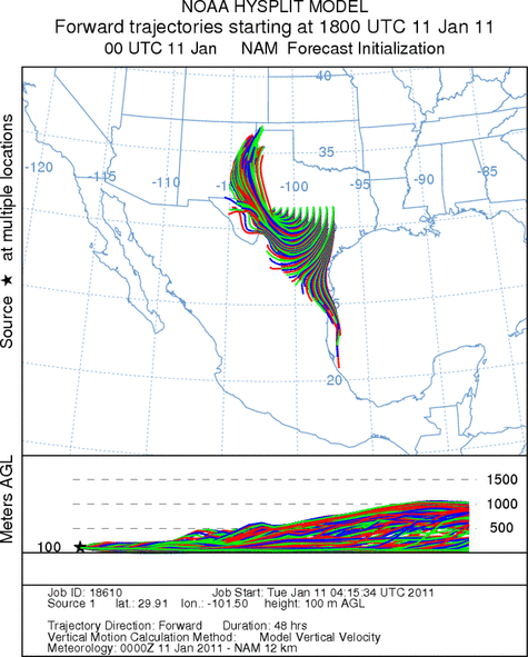
EDWARDS PLATEAU COMPOSITE
Prepared by: Estelle
Levetin (Faculty of Biological
Science, The
University of Tulsa, 800 S. Tucker Dr., Tulsa, OK 74104) and ) and Peter
K Van de Water (Department of Earth and Environmental Science, California State University Fresno,
2576 East San Ramon Avenue, M/S ST24, Fresno CA 93740-8039). This forecast gives the anticipated future track of
released Mountain Cedar pollen, weather conditions over the region and along the forecast pathway, and an estimated
time of arrival for various metropolitan areas.
Questions: Aerobiology Lab e-mail: pollen@utulsa.edu
Return to Forecasting Home Page