
The University of Tulsa
Mountain Cedar Pollen Forecast
Metropolitan Area |
Exposure Risk |
|
Dallas/Fort Worth |
Low |
|
Austin |
Moderate to High |
|
San Antonio |
Moderate to High |
Date Issued: 12 January 2011
Mountain Cedar Location(s): Edwards Plateau, Texas
Regional Weather: Wednesday, January 12 TX/OK:
The region today will be cold once again from the push of cold northern air that occurred earlier in the week.
Temperatures today from Oklahoma to south Texas will feel high temperatures in the 30s and 40s. Tomorrow a
change in the winds will start to warm the region back into seasonal conditions. In Oklahoma this morning partly
cloudy skies will prevail with temperatures in the mid- 20s in the central portion of the state to the low to
mid- 30s southward along the border. Winds will be moderate from the north and northeast but decreasing to light
and variable during the day. Tonight partly cloudy skies return with the lows in the mid-teens. Winds will remain
from the north but lighten to light and variable conditions. Tomorrow, sunny skies return with high temperatures
only reaching towards 40 in central and southern portions of the state. Tomorrow night will be partly cloudy with
light a variable winds and temperatures in the mid to upper 20s. In Texas, cloudy conditions will prevail around
the eastern edge of the Edwards Plateau with partly cloudy skies over the plateau and to the west. In the areas
surrounding the Edwards Plateau high temperatures will mostly be in the mid- 40s. Winds will be moderate from
the northeast. Tonight cloudy conditions return across the region. Temperatures will be below freezing in all
communities with temperatures in the mid to upper 20s. Winds will maintain themselves from the north to northeast
at light to moderate levels across most of the area. However, to the west a southeasterly breeze will arrive overnight
as warmer winds begin to work into the region for tomorrow. In the morning cloudy skies will predominate but a
general shift towards a southerly wind will bring warmer temperatures to the area. High temperatures will be in
the upper 40s to near 50 across much of the Edwards Plateau and in the surrounding communities. Winds will be
from the south in the western areas and from the east along the eastern edge of the Edwards Plateau. Winds will
be moderate to light during the day falling to light conditions tomorrow night and originating in the south. Low
temperatures will straddle the freezing mark with most areas in the lower 30s and upper 20s.
Trajectory weather: Air mass trajectories from the Edwards Plateau are changing today, but there is still
cold air entrenched in many areas. Cloudy to mostly cloudy skies will dominate today with high temperatures beginning
to rise out of the cold conditions of the past couple of days. Highs will be in the mid 40s today over the Edwards
Plateau and along the eastern edge communities. To the west temperatures will remain in the upper 30s today.
Winds will be from the north and northeast in most areas, however to the west southeasterly breezes will signal
the shift to a more southerly flow. Winds will remain light to moderate. Tonight cold conditions return most
areas into the mid- to low 20s and the winds remain moderate. Tomorrow the winds begin to shift, coming out of
the east and south towards the west side of the Edwards Plateau. High temperatures will rise by about 10 degrees
with most areas in the upper 40s and the southernmost communities flirting with 50 degrees. Tomorrow night temperatures
will fall back towards freezing conditions with a light southerly wind.
OUTLOOK: *** Moderate Threat today and Moderate Threat Tomorrow*** Poor conditions
for pollen release today andModerate conditions tomorrow. Moderate conditions for entrainment and transport exist
today and moderate conditions tomorrow. Today conditions will be driven by the last of the very cold conditions
that have settled over the region. Temperatures will be in the upper 30s to just above 40 today with cloudy and
mostly cloudy skies. Historically, we have found a significant reduction in pollen entrained in the atmosphere
at temperatures less than the mid- to upper 40s. However, the trees should be near their peak of release and
so some pollen may make it out, especially in urban areas that traditionally are warmer from the Heat Island
effect. If so, the atmosphere is moderately suited, so entrainment and travel may occur. This will mean that
urban areas may have moderate to high pollen levels, whereas the trees in more natural areas are constrained by
the temperature. Tomorrow and tomorrow night will be warmer with winds shifting from cold northerly conditions
to warmer southerly winds. Thursdays highs are expected to reach into the upper 40 degrees zone with areas along
the eastern edge of the Edwards Plateau pushing towards 50. Winds will be light to moderate from the east and
southeast moving any pollen entrained back up and over the Plateau towards the west then northwards. Wednesday
night, temperatures will return to the low 30s and upper 20s. In natural areas cold temperatures will create
poor conditions for pollen release today although the atmosphere will have moderate conditions for entrainment
and travel. Marginal conditions will continue tomorrow with moderating winds from the east and southeast tomorrow.
For these reasons we have a moderate threat today with some isolated pollen release in local populations, especially
in the southern areas of the trees distribution. The trees are in their most active portion of their pollination
season. The overall cold conditions tonight and Wednesday should retard pollen release although where conditions
are slightly warmer pollen may be abundant. We have historically found a significant drop off in pollen levels
at these temperatures. For these reasons we are calling for only a moderate threat today and conditions becoming
much more conducive for heavy pollination tomorrow.
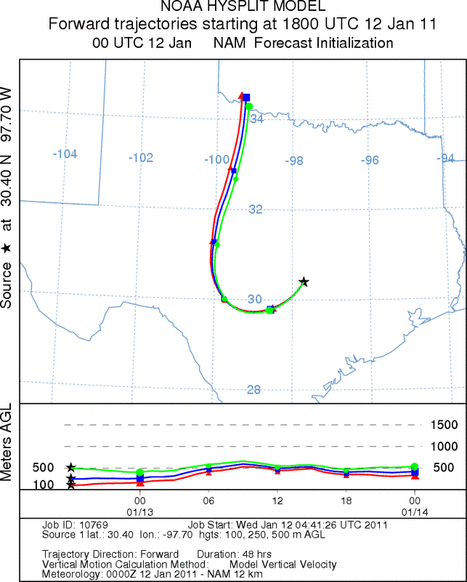
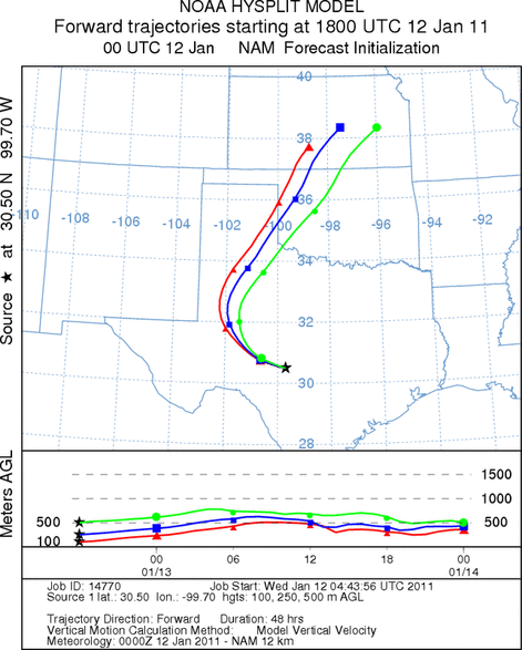
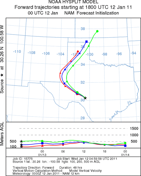
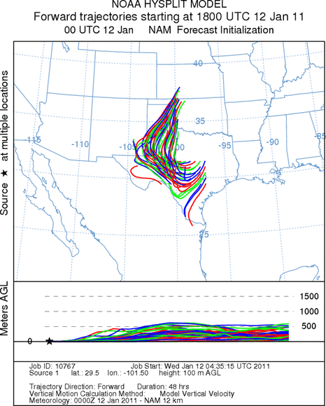
Trajectory Start (s) (shown by *
on map): Austin, TX; Junction, TX; Sonora, TX.
AUSTIN
JUNCTION
SONORA
EDWARDS PLATEAU COMPOSITE
Prepared by: Estelle
Levetin (Faculty of Biological
Science, The
University of Tulsa, 800 S. Tucker Dr., Tulsa, OK 74104) and ) and Peter
K Van de Water (Department of Earth and Environmental Science, California State University Fresno,
2576 East San Ramon Avenue, M/S ST24, Fresno CA 93740-8039). This forecast gives the anticipated future track of
released Mountain Cedar pollen, weather conditions over the region and along the forecast pathway, and an estimated
time of arrival for various metropolitan areas.
Questions: Aerobiology Lab e-mail: pollen@utulsa.edu
Return to Forecasting Home Page