The University of Tulsa
Mountain Cedar Pollen Forecast

Metropolitan Area |
Exposure Risk |
|
Oklahoma City |
High |
|
Tulsa |
High |
|
St. Louis MO |
Low |
Date Issued: 13 January 2011
Mountain Cedar Location(s): Arbuckle Mountains, OK
Regional Weather: Thursday, January 13 TX/OK:
The region today will remain cold from the entrenched cold northern air in the region. High temperatures today
from Oklahoma to south Texas will be in the 40s. Tomorrow a change in the winds will continue to warm the region
back into seasonal conditions, although another night of temperatures flirting with the freezing mark will occur
Thursday night. In Oklahoma this morning sunny skies will prevail with temperatures in the mid- 40s in the central
portion of the state to the low to mid- 40s southward along the border. Winds will be moderate from the south,
decreasing to light and variable winds from the south this afternoon and tonight. Tonight partly cloudy skies
return with the lows in the mid- to lower 20s from Oklahoma City towards the border with Texas. Tomorrow Oklahoma
will have partly cloudy skies with temperatures in the mid 40s and light winds from the south around 10 miles
per hour. The partly cloudy skies will remain tomorrow night with low temperatures in the mid- 20s to mid-30s.
In Texas, partly cloudy to mostly cloudy skies will occur with temperatures in the 40s across the area. Along
the eastern side of the Edwards Plateau winds will start from the northeast and shift during the day to a more
southeasterly and southern direction and be light to moderate in strength. On the western side of the Edwards
Plateau winds will be from the south at light to moderate conditions. Tonight temperatures will return below the
freezing level in most areas under cloudy to mostly cloudy skies. The areas along the eastern edge of the Edwards
Plateau will mostly stay above the freezing mark. Winds will be from the south and southeast at light to moderate
levels. Tomorrow temperatures will warm under cloudy skies with highs in most areas getting into the mid 50s.
Winds will be moderate and from the south. Tomorrow night a chance of rain occurs in most areas once again with
a 20% chance on the Edwards Plateau and a 30% chance in the communities surrounding the plateau. Temperatures
overnight will stay in the mid- to upper-30s and low 40s. Winds will continue from the south on the Edwards
Plateau especially in the west. In the edge communities the winds will be from the east.
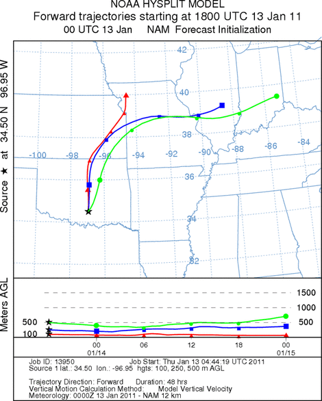
Trajectory weather: Air mass trajectories from the Arbuckle Mountains initially move northward on southerly
winds. The trajectories then turn towards the east north of Oklahoma as they get caught in weather conditions
in the central Plains and beyond. The region to the north remains cold with high temperatures in the high 30s
and low 40s. Conditions where the trees grow in southern Oklahoma will be in the mid-40s today as the high under
sunny skies. Winds will start light and variable but increase through the day to moderate conditions from the
south. Tonight partly cloudy skies will build and temperatures will dip into the mid-20s with winds returning
to light and variable conditions. Tomorrow partly cloudy conditions will remain with moderate to light winds from
the south slacking to light and variable conditions. High Temperatures will be in the mid 40s today and tomorrow.
Tomorrow night will see a repeat of tonight with temperatures in the mid-20s and light and variable conditions.
OUTLOOK: *** Moderate Threat today and Low Threat Tomorrow
*** Moderate conditions for pollen release today and moderate conditions tomorrow. Moderate conditions for
entrainment and transport exist today and tomorrow. Sunny skies will occur today but high temperatures will just
barely get into the range that we expect trees to release pollen. Sunny skies today may help with localized release
from the sunny and warmer sides of some trees. Winds will be moderate today allowing any pollen released to become
entrained within the atmosphere and therefore travel northward may occur. For these reasons there is a moderate
threat today. Tomorrow very similar conditions will exist but the skies will be partly cloudy and so less surface
warming should occur. In addition winds are predicted to be a bit calmer than today. Because of this we are putting
a Low threat for tomorrow for the Oklahoma population. Conditions are much better to the
south in Texas and the trajectories from those areas pass over the top of Oklahoma so while the southern Oklahoma
pollen dispersal is marginal see the TEXAS forecast for potential high levels of pollen across Oklahoma.
Trajectory Start (s) (shown by black
star on map): Davis, OK.
Prepared by: Estelle
Levetin
(Faculty
of Biological Science, The University of Tulsa, 800 S. Tucker Dr., Tulsa, OK 74104) and Peter
K Van de Water
(Department of Earth and Environmental Science, California State University Fresno, 2576 East San Ramon Avenue,
M/S ST24, Fresno CA 93740-8039). This forecast gives the anticipated future track of released Mountain Cedar pollen,
weather conditions over the region and along the forecast pathway, and an estimated time of arrival for various
metropolitan areas.
Questions: Aerobiology Lab e-mail: pollen@utulsa.edu
Return to Forecasting Home Page