
The University of Tulsa
Mountain Cedar Pollen Forecast
Metropolitan Area |
Exposure Risk |
|
Dallas/Fort Worth |
Moderate |
|
Austin |
Moderate |
|
San Antonio |
Moderate |
Date Issued: 14 January 2011
Mountain Cedar Location(s): Edwards Plateau, Texas
Regional Weather: Friday, January 14 TX/OK:
The region today will be warming somewhat out of the previous cold snap but with gaining humidity and the chance
of precipitation today, tonight, tomorrow and tomorrow night, especially to the south across central Texas. In
Oklahoma, today will begin with partly cloudy skies and light winds from the south. High temperatures will be
in the mid-40s in central Oklahoma and the upper 40s along the border with Texas where the Junipers grow. Tonights
lows will be in the upper 20s to lower 30s with winds calming to light and variable conditions. Tomorrow the region
will reach into the lower 50s with partly to mostly cloudy skies and light winds. Tomorrow night mostly cloudy
conditions will occur with the lows in the upper 20s to lower 30s. Winds will be moderate from the southeast
over the juniper population with a 20% chance of precipitation. In Texas today, cloudy conditions and increasing
humidity will occur across most of the Edwards Plateau region. High temperatures will be in the mid to upper 40s
to the east and into the low to mid-50s to the west. The communities along the eastern edge of the Plateau can
expect drizzle and foggy conditions this morning. Winds will be light to begin the day with increasing strength
during the afternoon in the central Plateau region and to the west. Tonight will be cloudy with an increasing
chance of rain across the region. Low temperatures will be in the mid to upper 30s across the Plateau and in the
mid to upper 40s along the eastern Edwards Plateau edge. Winds will be light to moderate from the east and southeast.
A 20% to 30% chance of precipitation exists in most areas of the Edwards Plateau tonight. Tomorrow cloudy skies
remain with a 20% to 40% chance of precipitation and warmer conditions. Most areas will be firmly in the 50s and
above with the communities along the Edwards Plateau edge reaching the upper 50s and low 60s. Winds will be light
and variable across the region. Tomorrow night will remain cloudy and low temperatures in the 30s and 40s to the
west and 40s to 50s to the east along the edge of the Edwards Plateau. The communities along the eastern edge
have a 60% chance of precipitation overnight whereas there is a declining chance further west. Winds will be light
and primarily from the southeast.
Trajectory weather: Air mass trajectories from the Edwards Plateau move due north on southerly winds from
the Edwards Plateau today. High temperatures across the region will be in the mid- to upper- 40s with some communities
to the west reaching into the low 50s. Moderate winds from the south and southeast will occur in most areas today.
Winds will be stronger towards the west compared to the eastern communities. The eastern edge communities can
expect to see drizzle and fog this morning. Tonight cloudy skies will prevail and temperatures will be in the
30s and 40s. Winds will be moderate from the southeast and east. Tomorrow warmer conditions will occur but with
an increasing chance of rain especially later in the day heading into tomorrow night. Temperatures will be in
the 50s and 60s with moderate winds from the southeast across the Edwards Plateau. In the edge communities winds
will be from the northeast at light to moderate levels. Tomorrow night will experience warm conditions with low
temperatures in the low 50s and 40s and light winds from the east and southeast. There will be a significant chance
of rain across the region tomorrow night.
OUTLOOK: *** Moderate Threat today and Moderate Threat Tomorrow*** fair conditions
for pollen release today and moderate conditions tomorrow. Marginal conditions for entrainment and transport exist
today. Todays conditions will be driven by the warming of the region that will move the last of the cold air out
of the region. High temperatures will be in the mid- to upper- 40s in most areas and the low 50s in the edge communities.
Light to moderate winds are expected, although skies will be cloudy across the area. The trees are near their
peak of release and so some pollination is expected to occur today, especially in urban areas that traditionally
are warmer.Tomorrow and tomorrow night will be warmer but there will be an increasing chance of precipitation beginning
tonight. Saturdays highs are expected to reach into the 50 degrees which will be more suitable for pollen release,
but the chance of rain will be increasing. Winds will be light to moderate from the south across much of the Edwards
Plateau. Along the eastern side and in the edge communities winds will return to the northeast. Tomorrow the
increase in humidity and heightened chance of rain will dampen entrainment and travel although some release can
be expected.
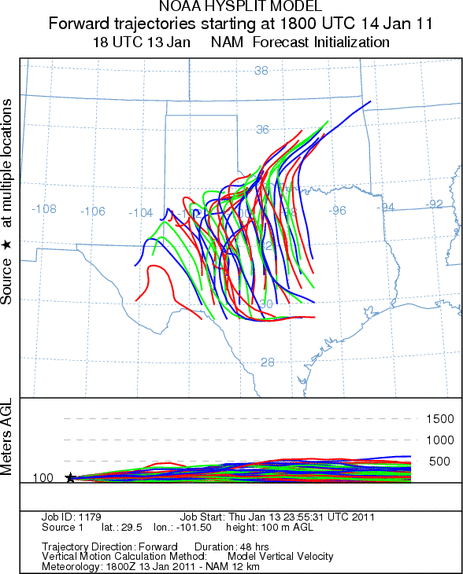
Trajectory Start (s) (shown by *
on map): Austin, TX; Junction, TX; Sonora, TX.
AUSTIN
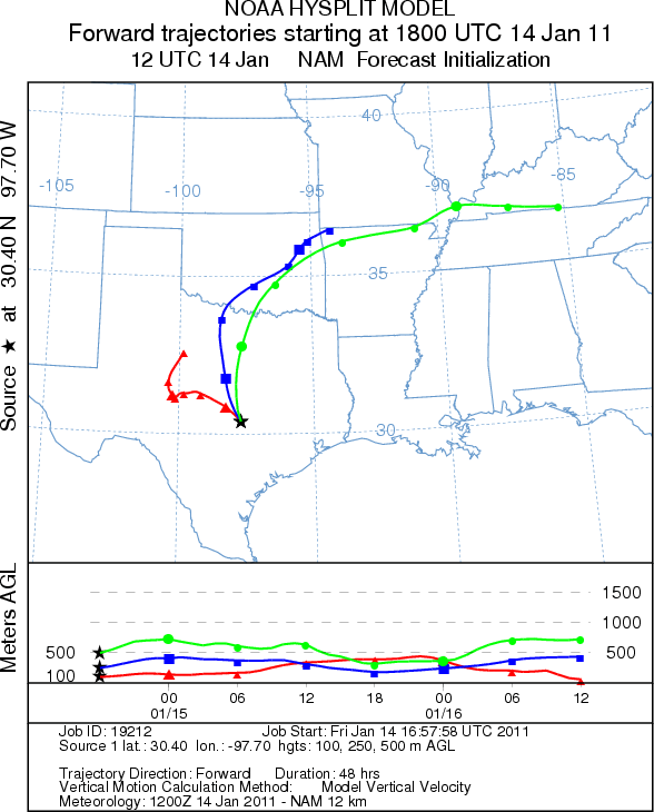
JUNCTION

SONORA
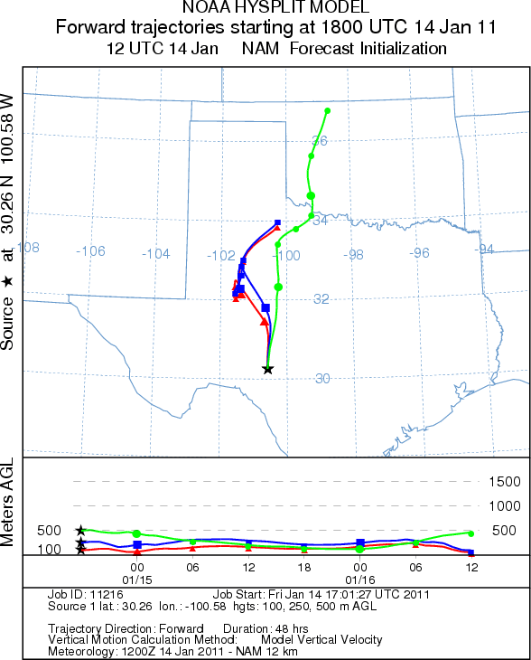
EDWARDS PLATEAU COMPOSITE
Prepared by: Estelle
Levetin (Faculty of Biological
Science, The
University of Tulsa, 800 S. Tucker Dr., Tulsa, OK 74104) and ) and Peter
K Van de Water (Department of Earth and Environmental Science, California State University Fresno,
2576 East San Ramon Avenue, M/S ST24, Fresno CA 93740-8039). This forecast gives the anticipated future track of
released Mountain Cedar pollen, weather conditions over the region and along the forecast pathway, and an estimated
time of arrival for various metropolitan areas.
Questions: Aerobiology Lab e-mail: pollen@utulsa.edu
Return to Forecasting Home Page