
The University of Tulsa
Mountain Cedar Pollen Forecast
Metropolitan Area |
Exposure Risk |
|
Dallas/Fort Worth |
Low to Moderate |
|
Austin |
Low to Moderate |
|
San Antonio |
Low to Moderate |
Date Issued: 15 January 2011
Mountain Cedar Location(s): Edwards Plateau, Texas
Regional Weather: Saturday, January 15 TX/OK:
The region today will be seasonal today with 40s and 50s in most areas although across Texas rain will be developing
especially along the eastern edge of the Edwards Plateau. Similar conditions will continue tomorrow as well.
In Oklahoma clear to partly cloudy skies with some morning fog will occur. High temperatures will be in the upper
40s in the central portion of the state and in the mid-50s along the border with Texas where the juniper trees
grow. Winds will be light and variable in the area. Tonight similar conditions will exist but with the addition
of light rain and showers throughout the area. There is a 20% chance of precipitation for the region. Tomorrow
that chance of rain increases to 30% during the day. Tomorrow night the moisture begins to clear out and the chance
of rain begins to diminish. Tomorrows high temperatures will only be in the mid 40s along the border. Overnight
temperatures will drop into the low 30s. Winds will remain light and variable throughout the entire forecast
period. In Texas, cloudy conditions will occur across the entire region today, tonight and tomorrow. This morning
there is a significant chance of rain along the eastern edge of the Edwards Plateau. The rain will spread tonight
and into tomorrow to most areas across the plateau. Tomorrow night conditions begin to clear up for the beginning
of the week. Today skies will be cloudy and temperatures will be in the lower to mid-50s. Winds will be from
the north to northeast at light to moderate levels. Tonight low temperatures will be mostly in the 40s and 50s.
Areas to the far west may drop into the upper 30s. Winds for the most part will continue from the northeast at
moderate levels. Tomorrow temperatures will warm a bit with most areas exceeding todays high temperatures. However,
rain and higher humidity will occur across the region. Winds will be moderate and from the north. Tomorrow night
skies begin to clear. The chance of precipitation will only occur on the eastern side of the Edwards Plateau.
Low temperatures will be in the 30s and 40s from west to east and winds will remain from the north at low to
moderate conditions.
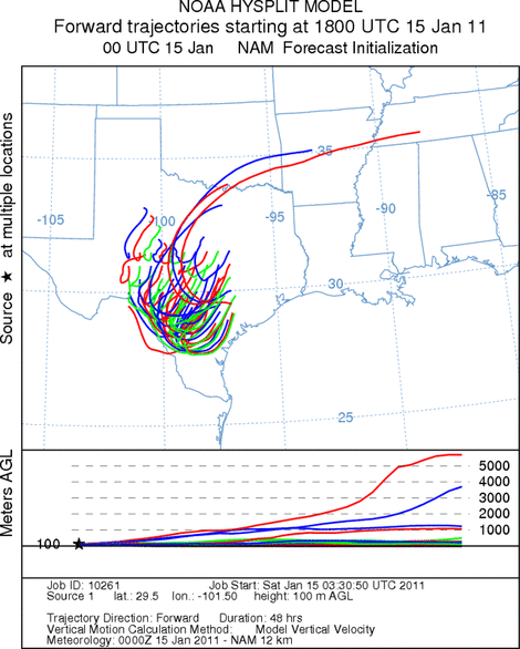
Trajectory weather: Air mass trajectories from the Edwards Plateau move southwest on northeasterly winds
coming across the Edwards Plateau today. High temperatures across the region will be in the mid- to upper- 50s
with some communities to the west reaching into the low 60s. Moderate winds from the northeast will occur in most
areas today. In the far west, winds will begin to switch to the southwest causing the trajectories to swirl back
northward over western Texas. The eastern edge communities will see a significant chance of rain today and that
moisture will continue to build tonight and tomorrow. We can expect to see drizzle and fog, showers and thunderstorms
today, tonight, tomorrow and then finally beginning to clear tomorrow night. Temperatures will be in the 50s and
60s both days with moderate winds. Tonight and tomorrow night temperatures will be mostly be in the 30s and 40s.
OUTLOOK: *** Low to Moderate Threat Today and Tomorrow***
Poor to moderate conditions for pollen release today and poor conditions tomorrow. Fair conditions for entrainment
and transport exist today and poor conditions tomorrow. Todays outlook will be driven by warmer temperatures and
also the incursion of moisture starting on the eastern side of the Edwards Plateau then moving westward. Temperatures
in the mid-50s should be good for pollen release, but the increasing amount of humidity in the atmosphere and the
building chance of rain should dampen any release. Throughout the forecast period, moderate winds will dominate
and therefore any pollen entrained will move locally and not outside of the region. Light to moderate winds are
expected and skies will be cloudy to mostly cloudy across the region. The trees are near their peak of release
and so pollination is expected to occur today, especially in sheltered urban areas that traditionally are warmer.
However the atmosphere is in a poor condition for entrainment and travel. This will mean that urban areas may
still be expected to have high pollen levels today in areas that are dry today. Tomorrow and tomorrow night will
be warmer but there will be an increasing chance of precipitation across the entire region. Sundays highs are
expected to reach into the 50s and 60s which will be suitable for pollen release, but the cloudy skies, high humidity,
and chance of rain will be increasing. The wind trajectories show the overall pattern moving entrained pollen
southwestward onto the Edwards Plateau and then swirl back northward over the western portion of the state. Tomorrow
the increase in humidity and heightened chance of rain will dampen entrainment and travel although some release
can be expected in drier areas.
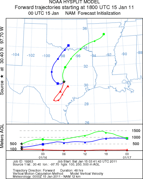
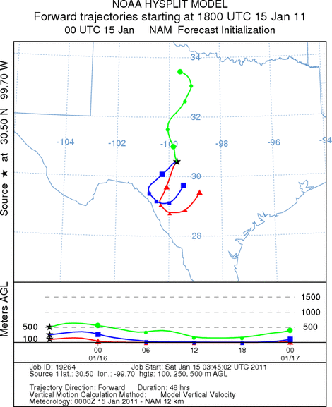
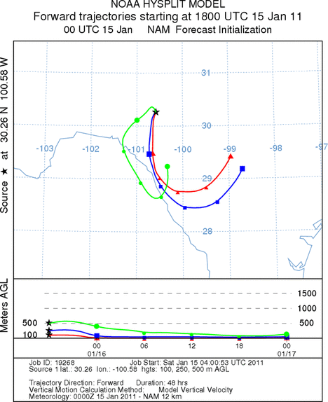
Trajectory Start (s) (shown by *
on map): Austin, TX; Junction, TX; Sonora, TX.
AUSTIN
JUNCTION
SONORA
EDWARDS PLATEAU COMPOSITE
Prepared by: Estelle
Levetin (Faculty of Biological
Science, The
University of Tulsa, 800 S. Tucker Dr., Tulsa, OK 74104) and ) and Peter
K Van de Water (Department of Earth and Environmental Science, California State University Fresno,
2576 East San Ramon Avenue, M/S ST24, Fresno CA 93740-8039). This forecast gives the anticipated future track of
released Mountain Cedar pollen, weather conditions over the region and along the forecast pathway, and an estimated
time of arrival for various metropolitan areas.
Questions: Aerobiology Lab e-mail: pollen@utulsa.edu
Return to Forecasting Home Page