The University of Tulsa
Mountain Cedar Pollen Forecast

Metropolitan Area |
Exposure Risk |
|
Oklahoma City |
Low |
|
Tulsa |
Low |
|
St. Louis MO |
Low |
Date Issued: 16 January 2011
Mountain Cedar Location(s): Arbuckle Mountains, OK
Regional Weather: Sunday, January 16 TX/OK:
The region today will be seasonal in the 40s and 50s north and the 60s towards the south. In the eastern areas
of Texas rain will be developing especially along the eastern edge of the Edwards Plateau. Conditions tomorrow
will be improving as the rain system moves out of the region this afternoon and evening. In Oklahoma mostly cloudy
skies with morning rain will occur. High temperatures will be in the lower 40s across the central portion of
the state and mid- 40s along the border with Texas where the juniper trees grow. Winds will be light and variable
in the area. Tonight similar mostly cloudy conditions will occur with a 20% chance of showers. Low temperatures
will be in the low 30s with light and variable winds in the area. Tomorrow mostly cloudy conditions will occur
but temperatures will rebound into the lower 50s. Winds will pick at 10 miles per hour from the south. Tomorrow
night mostly cloudy conditions and low temperatures in the upper 30s will occur. Winds will be light and variable.
There is a 20% chance of precipitation tomorrow night for central Oklahoma which may leak southward into the area
where the junipers grow. In Texas, cloudy conditions and a significant storm to the east will provide moisture
across the eastern portion of the Edwards Plateau as well as the edge communities. Temperatures will be in the
upper 50s and low 60s. The edge communities from the Dallas/Ft. Worth to San Antonio will have a significant
chance of precipitation today with showers and thunderstorms a potential during the day. Winds will be moderate
from the north. The chance of rain will diminish during the day, dropping to about 20% tonight. Mostly cloudy
conditions will continue, winds will remain from the north at moderate conditions, and temperatures will be in
the lower 40s and upper 30s. In western Texas, the chance of precipitation is lower with fog this morning and
a chance of a sporadic shower and thunderstorms. The moisture will be moving east so skies this afternoon and
tonight will start mostly cloudy and move to partly cloudy. Tomorrow, partly sunny to clear skies will occur with
temperatures warming into the 60s reaching near 70 to the west. Winds will switch to the southwest at moderate
toward strong levels. Tomorrow night partly cloudy skies will continue to the east and mostly clear skies to the
west will occur as low temperatures dip into the upper 30s and lower 40s. Winds will continue at moderate levels
from the southwest.
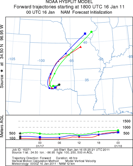
Trajectory weather: Air mass trajectories from the Arbuckle Mountains initially move southwestward on northeasterly
winds, but will turn towards the north as southwesterly winds move into the region. The trajectories move across
the state and into the central Great Plains. The region to the north remains cold with high temperatures in the
low 40s for central Oklahoma. Conditions where the trees grow in southern Oklahoma will be in the mid-40s today
under mostly cloudy skies, with higher humidity and the chance of precipitation. Winds will be light and variable
for most of the forecast period. Tonight temperatures will be near freezing across the region. There is a 20%
chance of precipitation with light rain and showers today and tonight. Winds will be light and variable. Tomorrow
the chance of rain decreases with high temperatures warming into the mid- 50s. Winds will build from the south
at moderate levels tomorrow and then relaxing to light and variable conditions tomorrow night. Tomorrow night
temperatures will cool into the mid- 30s and the chance of precipitation will continue to decline as the region
begins to dry out.
OUTLOOK: *** Low Threat today and High Threat Tomorrow ***
Poor conditions for pollen release today and good conditions tomorrow. poor conditions for entrainment and
transport exist today with good conditions tomorrow. Cloudy skies will occur today with high temperatures just
at the mid- 40s. There will be a 40% chance of rain today along with light and variable winds. These conditions
will make any pollen release and entrainment marginal and therefore travel northward may occur but will be very
limited. For these reasons there is a low threat today. Tomorrow conditions will be much better as the chance
of precipitation leaves the area, conditions begin to dry and warmer conditions come in tomorrow on southwestern
winds. Today the area will begin to dry with warmer southwestern winds moving in and a much greater chance of
pollen release in the area tomorrow.
Trajectory Start (s) (shown by black
star on map): Davis, OK.
Prepared by: Estelle
Levetin
(Faculty
of Biological Science, The University of Tulsa, 800 S. Tucker Dr., Tulsa, OK 74104) and Peter
K Van de Water
(Department of Earth and Environmental Science, California State University Fresno, 2576 East San Ramon Avenue,
M/S ST24, Fresno CA 93740-8039). This forecast gives the anticipated future track of released Mountain Cedar pollen,
weather conditions over the region and along the forecast pathway, and an estimated time of arrival for various
metropolitan areas.
Questions: Aerobiology Lab e-mail: pollen@utulsa.edu
Return to Forecasting Home Page