
The University of Tulsa
Mountain Cedar Pollen Forecast
Metropolitan Area |
Exposure Risk |
|
Dallas/Fort Worth |
Low |
|
Austin |
Low to Moderate |
|
San Antonio |
Low to Moderate |
Date Issued: 16 January 2011
Mountain Cedar Location(s): Edwards Plateau, Texas
Regional Weather: Sunday, January 16 TX/OK:
The region today will be seasonal in the 40s and 50s north and the 60s towards the south. In the eastern areas
of Texas rain will be developing especially along the eastern edge of the Edwards Plateau. Conditions tomorrow
will be improving as the rain system moves out of the region this afternoon and evening. In Oklahoma mostly cloudy
skies with morning rain will occur. High temperatures will be in the lower 40s across the central portion of
the state and mid- 40s along the border with Texas where the juniper trees grow. Winds will be light and variable
in the area. Tonight similar mostly cloudy conditions will occur with a 20% chance of showers. Low temperatures
will be in the low 30s with light and variable winds in the area. Tomorrow mostly cloudy conditions will occur
but temperatures will rebound into the lower 50s. Winds will pick at 10 miles per hour from the south. Tomorrow
night mostly cloudy conditions and low temperatures in the upper 30s will occur. Winds will be light and variable.
There is a 20% chance of precipitation tomorrow night for central Oklahoma which may leak southward into the area
where the junipers grow. In Texas, cloudy conditions and a significant storm to the east will provide moisture
across the eastern portion of the Edwards Plateau as well as the edge communities. Temperatures will be in the
upper 50s and low 60s. The edge communities from the Dallas/Ft. Worth to San Antonio will have a significant
chance of precipitation today with showers and thunderstorms a potential during the day. Winds will be moderate
from the north. The chance of rain will diminish during the day, dropping to about 20% tonight. Mostly cloudy
conditions will continue, winds will remain from the north at moderate conditions, and temperatures will be in
the lower 40s and upper 30s. In western Texas, the chance of precipitation is lower with fog this morning and
a chance of a sporadic shower and thunderstorms. The moisture will be moving east so skies this afternoon and
tonight will start mostly cloudy and move to partly cloudy. Tomorrow, partly sunny to clear skies will occur with
temperatures warming into the 60s reaching near 70 to the west. Winds will switch to the southwest at moderate
toward strong levels. Tomorrow night partly cloudy skies will continue to the east and mostly clear skies to the
west will occur as low temperatures dip into the upper 30s and lower 40s. Winds will continue at moderate levels
from the southwest.
Trajectory weather: Air mass trajectories from the Edwards Plateau move south on northerly winds coming
across the Edwards Plateau today and tonight. High temperatures across the region will be in the mid- to upper-
50s with some communities to the west reaching into the low 60s. Moderate winds from the north will occur in
most areas today. This morning there is a significant chance of rain as a significant weather system occurs along
the eastern area of the Edwards Plateau and the surrounding communities. Fog, rain showers and thunderstorms are
in the forecast. The chance of precipitation drops tonight as the system moves further east. In the far west today,
winds will begin to switch to the southwest causing the trajectories to swirl back northward over western Texas.
The switch of wind will continue across the Edwards Plateau with southwesterly winds dominating tomorrow. Along
with the change in winds, high temperatures tomorrow will be in the 60s and some areas reaching nearly 70. Southwesterly
winds will continue at moderate levels. Tomorrow is expected to be partly to mostly sunny.
OUTLOOK: *** Moderate today and High Threat Tomorrow***
moderate conditions for pollen release today and good conditions tomorrow. Moderate conditions for entrainment
and transport exist today and good conditions tomorrow. Todays conditions will be driven by drying conditions
and the potential of precipitation on the eastern side of the Edwards Plateau. Temperatures in the mid-50s to
lower 60s should be good for pollen release where the atmosphere is dry. To the east increasing amounts of humidity
in the atmosphere and the building chance of rain should dampen any release. Therefore pollen may be common in
the western areas but relatively scarce in the eastern communities. Much of the concentration will depend upon
how much precipitation fell and how fast the areas are drying out. Today, moderate winds from the north will dominate
and therefore any pollen entrained will move more locally and southward. Tomorrow winds will pick up and shift,
coming out of the southwest. Today skies will reflect the moisture in the region and be cloudy to mostly cloudy.
Tomorrow sunny skies to partly sunny skies will prevail. The trees are near their peak of release and so pollination
is expected to occur as conditions improve, especially in sheltered urban areas that traditionally are warmer and
will dry more quickly. However the atmosphere is in a poor condition for entrainment and travel today. This will
mean that urban areas may still be expected to experience some pollen today. Tomorrow and tomorrow night will
be warmer with sunny skies and warmer, stronger winds from the southwest. Mondays highs are expected to reach
into the 60s and nearing 70 in some places which will be very suitable for pollen release. The wind trajectories
show the overall pattern moving entrained pollen south then turn to the north on southwesterly winds tomorrow.
Today poor conditions will be followed tomorrow by really good conditions.
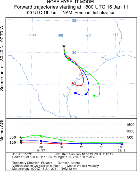
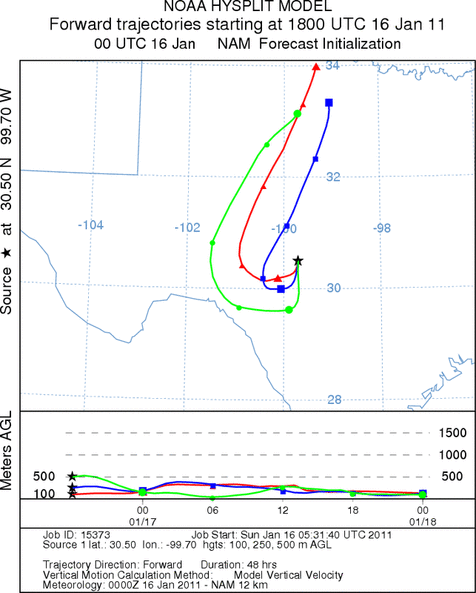
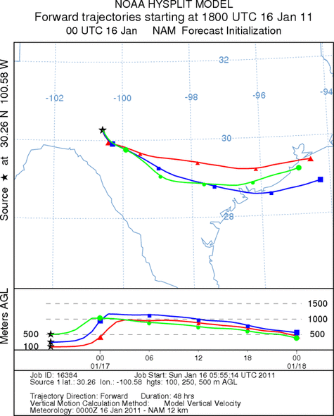
Trajectory Start (s) (shown by *
on map): Austin, TX; Junction, TX; Sonora, TX.
AUSTIN
JUNCTION
SONORA
EDWARDS PLATEAU COMPOSITE
Prepared by: Estelle
Levetin (Faculty of Biological
Science, The
University of Tulsa, 800 S. Tucker Dr., Tulsa, OK 74104) and ) and Peter
K Van de Water (Department of Earth and Environmental Science, California State University Fresno,
2576 East San Ramon Avenue, M/S ST24, Fresno CA 93740-8039). This forecast gives the anticipated future track of
released Mountain Cedar pollen, weather conditions over the region and along the forecast pathway, and an estimated
time of arrival for various metropolitan areas.
Questions: Aerobiology Lab e-mail: pollen@utulsa.edu
Return to Forecasting Home Page