The University of Tulsa
Mountain Cedar Pollen Forecast

Metropolitan Area |
Exposure Risk |
|
Oklahoma City |
Low |
|
Tulsa |
Low |
|
St. Louis MO |
Low |
Date Issued: 18 January 2011
Mountain Cedar Location(s): Arbuckle Mountains, OK
Regional Weather: Tuesday, January 18 TX/OK:
The region will be warming today and tomorrow with temperatures in the 60s across Texas today, but just getting
to near 50 in southernmost Oklahoma. Skies to the north will be partly cloudy but clearing skies and sunshine
is expected across Texas. In Oklahoma partly cloudy skies will occur with light winds from the north. Tonight
partly cloudy skies will continue with temperatures dropping into the mid- to upper 20s. Tomorrow will see continue
partly cloudy skies but a bit warmer with temperatures in the upper 40s to mid-50s southward along the border.
Winds will increase from light and variable conditions to a steady, moderate wind from the southeast. Tomorrow
night the chance of precipitation in Oklahoma increases with rain and frozen rain a possibility. Temperatures
will remain near freezing overnight and winds will have shifted coming from the east. In Texas sunny to mostly
sunny skies are expected today across the region. The communities along the eastern edge of the Edwards Plateau
can expect to see fog this morning but that will quickly burn off. Winds will be moderate and from the north.
High temperatures are expected to be in the 60s across the region. Overnight the skies will remain mostly clear
and low temperatures will drop into the mid- to upper- 30s in most places. Winds will be from the northeast at
light to moderate conditions. Tomorrow the areas to the east will remain mostly to partly sunny whereas western
skies will be partly cloudy. Temperatures will remain in the 60s but the winds will shift from the north to coming
from the south and southeast, and increase their strength especially in the west. The clouds in the west will
continue to build into tomorrow night with a chance of showers from Dallas northwards into Oklahoma. South of
the areas with potential rain fog will build overnight. The areas along the eastern edge of the Plateau have a
chance of drizzle mixed in with the fog. Temperatures in Texas will remain warm with most low readings in the
40s to low 50s. Winds will be from the south at moderate conditions.
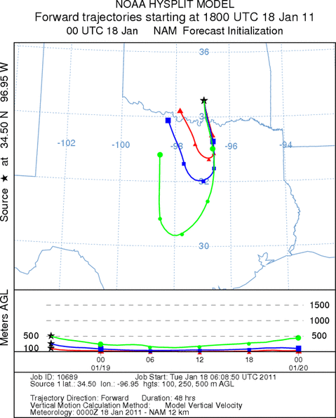
Trajectory weather: Air mass trajectories from the Arbuckle Mountains initially move south on northerly
winds during today, but then turn towards the north overnight as southeasterly winds move into the region. The
trajectories move into northern Texas and then back towards the border region and into Oklahoma. Today, temperatures
will barely make it to 50 degrees in the juniper population and skies will be partly cloudy with light to variable
winds. Overnight low temperatures will be below freezing. Conditions where the trees grow in southern Oklahoma
will barely reach 50 today under mostly cloudy skies. Winds will be light and variable today and tonight, then
switch to moderate levels from the southeast tomorrow and tomorrow night. Tomorrow will have slightly warmer conditions
with high temperatures expected in the mid 50s. Winds will be from the southeast at moderate levels. Tomorrow
night there is and increasing chance of rain from the north. Tomorrow nights temperatures are expected to be
at or below freezing so any precipitation will fall as rain or freezing rain.
OUTLOOK: *** Low Threat today and Moderate Threat Tomorrow
*** poor conditions for pollen release today and moderate conditions tomorrow. poor conditions for entrainment
and transport exist today with good conditions tomorrow. Partly cloudy skies will occur today with high temperatures
just reaching 50s. Light and variable winds from the north will move the air mass southward on northerly winds.
These conditions will be marginal for pollen release and with light winds be marginal for entrainment. Travel
will be towards the south on light and variable winds. Tomorrow, winds will shift and become stronger from the
southeast. For these reasons there is a low threat of pollen release, entrainment and travel today. Tonight partly
cloudy skies will be maintained with temperatures in the twenties and very light winds. Tomorrow winds will shift
and build towards moderate levels from the southeast, so winds moving southward today and tonight will circle towards
the west and move back over Oklahoma. Tomorrow night there is an increasing chance of rain across the Oklahoma
region moving in from the north and west.
Trajectory Start (s) (shown by black
star on map): Davis, OK.
Prepared by: Estelle
Levetin
(Faculty
of Biological Science, The University of Tulsa, 800 S. Tucker Dr., Tulsa, OK 74104) and Peter
K Van de Water
(Department of Earth and Environmental Science, California State University Fresno, 2576 East San Ramon Avenue,
M/S ST24, Fresno CA 93740-8039). This forecast gives the anticipated future track of released Mountain Cedar pollen,
weather conditions over the region and along the forecast pathway, and an estimated time of arrival for various
metropolitan areas.
Questions: Aerobiology Lab e-mail: pollen@utulsa.edu
Return to Forecasting Home Page