
The University of Tulsa
Mountain Cedar Pollen Forecast
Metropolitan Area |
Exposure Risk |
|
Dallas/Fort Worth |
Moderate |
|
Austin |
High |
|
San Antonio |
High |
Date Issued: 18 January 2011
Mountain Cedar Location(s): Edwards Plateau, Texas
Regional Weather: Tuesday, January 18 TX/OK:
The region will be warming today and tomorrow with temperatures in the 60s across Texas today, but just getting
to near 50 in southernmost Oklahoma. Skies to the north will be partly cloudy but clearing skies and sunshine
is expected across Texas. In Oklahoma partly cloudy skies will occur with light winds from the north. Tonight
partly cloudy skies will continue with temperatures dropping into the mid- to upper 20s. Tomorrow will see continue
partly cloudy skies but a bit warmer with temperatures in the upper 40s to mid-50s southward along the border.
Winds will increase from light and variable conditions to a steady, moderate wind from the southeast. Tomorrow
night the chance of precipitation in Oklahoma increases with rain and frozen rain a possibility. Temperatures
will remain near freezing overnight and winds will have shifted coming from the east. In Texas sunny to mostly
sunny skies are expected today across the region. The communities along the eastern edge of the Edwards Plateau
can expect to see fog this morning but that will quickly burn off. Winds will be moderate and from the north.
High temperatures are expected to be in the 60s across the region. Overnight the skies will remain mostly clear
and low temperatures will drop into the mid- to upper- 30s in most places. Winds will be from the northeast at
light to moderate conditions. Tomorrow the areas to the east will remain mostly to partly sunny whereas western
skies will be partly cloudy. Temperatures will remain in the 60s but the winds will shift from the north to coming
from the south and southeast, and increase their strength especially in the west. The clouds in the west will
continue to build into tomorrow night with a chance of showers from Dallas northwards into Oklahoma. South of
the areas with potential rain fog will build overnight. The areas along the eastern edge of the Plateau have a
chance of drizzle mixed in with the fog. Temperatures in Texas will remain warm with most low readings in the
40s to low 50s. Winds will be from the south at moderate conditions.
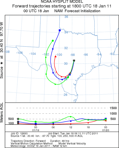
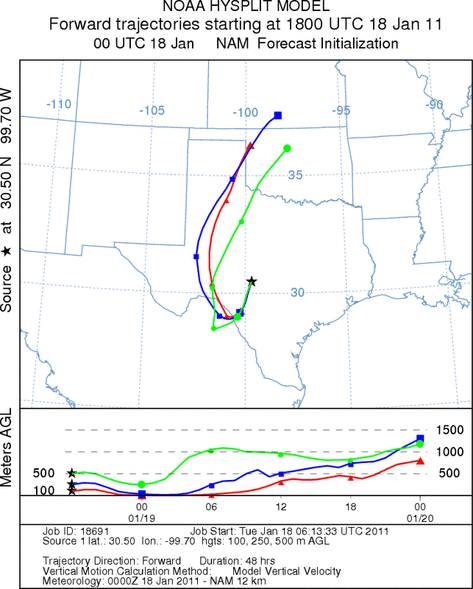
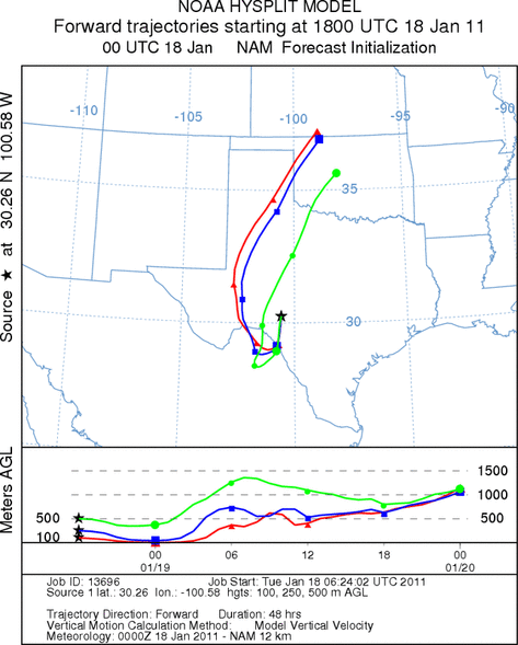
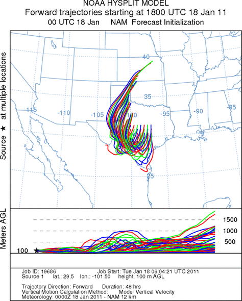
Trajectory weather: Air mass trajectories from Texas initially move south on northerly winds during today
at ground level, but then turn towards the north late tonight as southeasterly winds move into the region for tomorrow.
The trajectories move into southern Texas and then back towards Oklahoma tomorrow and tomorrow night. Today,
temperatures will be int the mid to upper 60s in most areas. This morning there will be fog developing along the
eastern edge of the Edwards Plateau which may hold back high temperatures by four or five degrees. Winds will
be moderate from the north today and then begin to switch to a southeasterly flow tonight. The winds will begin
to turn starting in the west. Overnight low temperatures will be below in the mid 30s in most places. Conditions
within the tree population will be well into the 60s today and tomorrow under sunny skies today and partly cloudy
skies tomorrow. Tomorrow night there is and increasing chance of rain to the north in Oklahoma and just south
into north Texas. Further south increasing humidity will result in the return of fog to many areas on the eastern
Plateau and in the surrounding communities. Temperatures will remain relatively warm with the lows in most places
remaining in the 40s and 50s.
OUTLOOK: *** High Threat today and High Threat Tomorrow*** Very good conditions
for pollen release today and tomorrow. Moderate conditions for entrainment, good conditions for entrainment tomorrow
and moderate conditions for transport exist today and tomorrow. Todays conditions will be driven by warm sunny
skies and moderate winds across the Edwards Plateau. Temperatures are expected in the 60s in most areas with moderate
winds today but building tomorrow when they will switch from todays northerly direction and come out of the southeast.
These warm conditions will be very good for pollen release from the cones. Light to moderate winds will aid the
released pollen to make it into the atmosphere, however dense conditions will hold most of the entrained pollen
near the surface during its travel. Travel will begin towards the south during the day, but then turn northward
and to the west as the winds turn overnight and tomorrow. The change in direction will bring it back over the
westcentral Texas region. Therefore pollen will be common in the areas surrounding the juniper population, but
will be centered over the top of the Edwards Plateau and west central Texas. The trees are near their traditional
peak of release and so pollination is expected to occur in most areas where they grow, especially in sheltered
urban areas that traditionally are warmer. However the atmosphere is in a moderate condition for entrainment and
travel today. This will mean that areas throughout the junipers distribution will experience significant pollen
today. Tomorrow and tomorrow night will be about the same with partly sunny skies east and partly cloudy skies
west. Moderate winds from the southeast and south will build from todays more moderate conditions. Tuesdays
highs are expected to reach into the 60s again which will once again be very suitable for pollen release. The
wind trajectories show the overall pattern moving entrained pollen over the top of the Edwards Plateau therefore
those areas can expect significant amounts of pollen in the atmosphere. Areas further away from the juniper population
will see a decreasing occurrence of pollen in the atmosphere.
Trajectory Start (s) (shown by *
on map): Austin, TX; Junction, TX; Sonora, TX.
AUSTIN
JUNCTION
SONORA
EDWARDS PLATEAU COMPOSITE
Prepared by: Estelle
Levetin (Faculty of Biological
Science, The
University of Tulsa, 800 S. Tucker Dr., Tulsa, OK 74104) and ) and Peter
K Van de Water (Department of Earth and Environmental Science, California State University Fresno,
2576 East San Ramon Avenue, M/S ST24, Fresno CA 93740-8039). This forecast gives the anticipated future track of
released Mountain Cedar pollen, weather conditions over the region and along the forecast pathway, and an estimated
time of arrival for various metropolitan areas.
Questions: Aerobiology Lab e-mail: pollen@utulsa.edu
Return to Forecasting Home Page