The University of Tulsa
Mountain Cedar Pollen Forecast

Metropolitan Area |
Exposure Risk |
|
Oklahoma City |
Low |
|
Tulsa |
Low |
|
St. Louis MO |
Low |
Date Issued: 20 January 2011
Mountain Cedar Location(s): Arbuckle Mountains, OK
Regional Weather: Thursday, January 20 TX/OK:
North wind arrived in the region and the high temperatures have dropped below 60 degrees in most areas across Texas
and remain cold in Oklahoma today. In Oklahoma mostly cloudy skies will occur with a 50% chance of snow and light
freezing rain from the center of the state south towards the Texas border. Winds will be moderate to strong from
the north. Tonight partly cloudy skies with overnight temperatures well into the mid-20s and below will occur.
Tomorrow warmer conditions will enter into the region on moderate southerly winds. Temperatures are expected
to be in the upper to mid- 40s. Tomorrow night low temperatures will once again be below freezing with winds from
the southwest declining to light and variable conditions. In Texas today, mostly cloudy skies will occur this
morning with a chance of fog in most areas. Temperatures will be in the 40s and low 50s in western Texas and
in the 50s on the Edwards Plateau and throughout the edge communities. Winds will be moderate to strong from the
north with many places in the eastern forecast area seeing gust between 30 and 35 miles per hour. Tonight partly
cloudy conditions with the strong winds maintained. Low temperatures will be well below freezing with the western
areas into the teens and the Plateau and surrounding communities in the mid- to upper 20s. Tomorrow, high temperatures
will remain in the 50s under sunny skies. Winds will begin to calm with southwesterly breezes moving into the
western areas, especially later during the day. Tomorrow night will return to cold conditions, but most temperatures
will be in the mid- to upper 20s and lower 30s. Winds will continue at light to moderate conditions from the southwest.
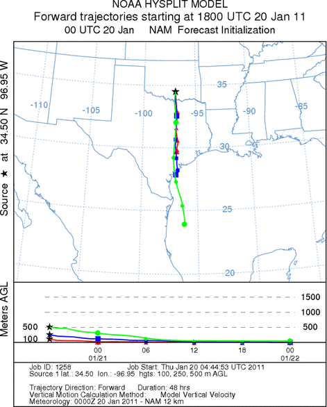
Trajectory weather: Air mass trajectories from the Arbuckle Mountains move south on strong northerly winds.
The trajectories move into Texas, across the Dallas/Fort Worth area and the Edwards Plateau. Today, temperatures
will barely make it into the mid-30s with a 50% chance of precipitation. Overnight low temperatures will be below
freezing and remain breezy from the north. Conditions where the trees grow in southern Oklahoma will reach only
the mid- 30s today under mostly cloudy skies. Winds will be moderate tonight from the north. Tomorrow will warm
a bit with high temperatures just getting in the mid- to upper 40s. The region will be drying with no chance of
precipitation in the forecast. Winds will switch from todays northerly directions and come from the south at
moderate levels. Skies will remain partly cloudy across southern Oklahoma and northern Texas, clearing further
south in central Texas.
OUTLOOK: *** Low Threat today and Low Threat Tomorrow *** poor conditions for
pollen release today and poor conditions tomorrow. good conditions for entrainment but poor conditions for transport
exist today and tomorrow. Mostly cloudy skies today will occur with high temperatures in the 30s today then tomorrow
a slight warming with highs in the mid 40s. Moderate winds from the north will drive southward today and overnight
then late tomorrow switch to a southerly direction moving the air masses back north. These conditions will be
poor for pollen release. The strong winds will be good for entrainment if any pollen leaks from the cones, but
the air masses are very cold and dense moving along the ground. Any pollen in the atmosphere will tend to be removed
by impaction on leaves and other vegetation at ground level. For these reasons there is a low threat both today
and tomorrow.
Trajectory Start (s) (shown by black
star on map): Davis, OK.
Prepared by: Estelle
Levetin
(Faculty
of Biological Science, The University of Tulsa, 800 S. Tucker Dr., Tulsa, OK 74104) and Peter
K Van de Water
(Department of Earth and Environmental Science, California State University Fresno, 2576 East San Ramon Avenue,
M/S ST24, Fresno CA 93740-8039). This forecast gives the anticipated future track of released Mountain Cedar pollen,
weather conditions over the region and along the forecast pathway, and an estimated time of arrival for various
metropolitan areas.
Questions: Aerobiology Lab e-mail: pollen@utulsa.edu
Return to Forecasting Home Page