The University of Tulsa
Mountain Cedar Pollen Forecast

Metropolitan Area |
Exposure Risk |
|
Oklahoma City |
Moderate |
|
Tulsa |
Low to Moderate |
|
St. Louis MO |
Low |
Date Issued: 22 January 2011
Mountain Cedar Location(s): Arbuckle Mountains, OK
Regional Weather: Saturday, January 22 TX/OK:
Conditions across the region will begin to warm today with winds from a more southerly to southwesterly direction.
Skies today across the region will be sunny except in Oklahoma where partly cloudy conditions will exist. In
Oklahoma temperatures will be in the mid- to upper- 50s. Winds will be from the south to southwest at 10 to 15
miles per hour. Tonight the skies in Oklahoma will become mostly cloudy with low temperatures in the upper 20s
to low 30s. Winds will decrease but remain from an overall southerly direction in the areas near the Texas border.
Tomorrow mostly cloudy skies will occur in the southern portion of the state with temperatures cooling once again
as northerly winds take over. High temperatures tomorrow are expected to just reach the mid 40s. Winds will
be from the north and northwest at moderate conditions. Tomorrow night partly cloudy conditions will occur with
a moderate west to northwest wind and temperatures falling to the low 20s. In Texas today, high temperatures will
be in the mid to low 60s under sunny skies. Winds will begin from the west in most areas at light to moderate
conditions from the west picking up in intensity in the afternoon and becoming more of a southerly direction.
Tonight mostly clear conditions will occur with temperatures in the mid 30s in most areas. The southern and urban
regions of the eastern edge communities will see low temperatures in the upper 30s and maybe even the low 40s.
Winds will remain from the south and southwest at moderate to strong levels early in the western regions and then
calming and shifting back to a southwesterly flow. Tomorrow, skies will start partly cloudy with clearing to partly
sunny conditions as the day progresses. Temperatures will cool in most regions by 10 degrees as the winds, once
again switch to a northerly direction. High temperatures are expected in the mid 50s in most areas. Winds will
remain moderate to calm but from the north. Tomorrow night mostly clear skies will occur to the west and partly
cloudy conditions to the east. Temperatures in the west will drop into the mid 20s whereas surrounding the plateau
temperatures will be in the mid 30s. Winds will remain from the west at light to moderate levels.
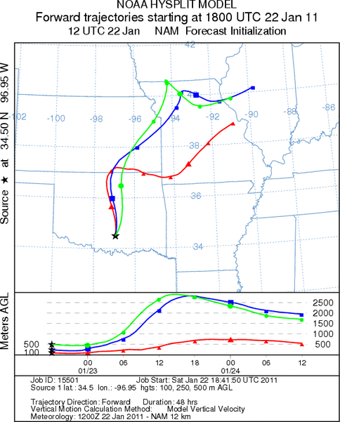
Trajectory weather: Air mass trajectories from the Arbuckle Mountains move due north and then off into the
central Great Plains states as they get wrapped into regional weather patterns. Pollen release from the Arbuckle
Mountain population will move on light to moderate southerly winds today and tonight. Today high temperatures
will reach into the upper 50s range under partly cloudy skies. Conditions should be good for some release. Tonight
low temperatures will be in the upper-20s to low 30s with light winds from the southeast. Tomorrow mostly cloudy
skies will prevail and winds will be moderate to moderately strong from the north and northwest. The high temperature
tomorrow will barely get to the mid-40s with the invasion of the cold northerly winds. Low temperatures tomorrow
night will return back to the low-20s. The region continues to dry with no chance of precipitation in the forecast.
OUTLOOK: *** Moderate Threat today and Low Threat Tomorrow
*** good conditions for pollen release today and poor conditions tomorrow. moderate conditions for entrainment
and travel today but poor conditions for tomorrow. Partly cloudy skies will occur with high temperatures in the
mid-50s today then tomorrow cold conditions return with highs in the mid 40s. Todays temperatures are conducive
for pollen release, but then it will cool tonight leaving tomorrow just on the cusp for pollen release. Moderate
winds from the south and southwest will drive any discharge north quickly across Oklahoma and into the central
Great Plains region. The atmosphere looks to be stable both today leading to good conditions for entrainment and
travel. North of Oklahoma conditions become very buoyant raising most near ground trajectories high into the atmosphere.
Mostly cloudy conditions will return tomorrow with cooler temperatures brought by the colder north wind. High
temperatures in southern Oklahoma will barely reach into the 40s and winds will remain moderate during the forecast
period. Tomorrow night will see temperatures dip back into the 20s. Tomorrows conditions are very marginal to
poor for any pollen release. In addition to the possible incursion of pollen from the Arbuckles, the trajectories
from the Texas populations may bring cedar pollen into central and northeastern Oklahoma this evening and overnight.
Trajectory Start (s) (shown by black
star on map): Davis, OK.
Prepared by: Estelle
Levetin
(Faculty
of Biological Science, The University of Tulsa, 800 S. Tucker Dr., Tulsa, OK 74104) and Peter
K Van de Water
(Department of Earth and Environmental Science, California State University Fresno, 2576 East San Ramon Avenue,
M/S ST24, Fresno CA 93740-8039). This forecast gives the anticipated future track of released Mountain Cedar pollen,
weather conditions over the region and along the forecast pathway, and an estimated time of arrival for various
metropolitan areas.
Questions: Aerobiology Lab e-mail: pollen@utulsa.edu
Return to Forecasting Home Page