
The University of Tulsa
Mountain Cedar Pollen Forecast
Metropolitan Area |
Exposure Risk |
|
Dallas/Fort Worth |
High |
|
Austin |
High |
|
San Antonio |
High |
Date Issued: 22 January 2011
Mountain Cedar Location(s): Edwards Plateau, Texas
Regional Weather: Saturday, January 22 TX/OK:
Conditions across the region will begin to warm today with winds from a more southerly to southwesterly direction.
Skies today across the region will be sunny except in Oklahoma where partly cloudy conditions will exist. In
Oklahoma temperatures will be in the mid- to upper-50s. Winds will be from the south to southwest at 10 to 15
miles per hour. Tonight the skies in Oklahoma will become mostly cloudy with low temperatures in the upper 20s
to low 30s. Winds will decrease but remain from an overall southerly direction in the areas near the Texas border.
Tomorrow mostly cloudy skies will occur in the southern portion of the state with temperatures cooling once again
as northerly winds take over. High temperatures tomorrow are expected to just reach the mid 40s. Winds will be
from the north and northwest at moderate conditions. Tomorrow night partly cloudy conditions will occur with a
moderate west to northwest wind and temperatures falling to the low 20s. In Texas today, high temperatures will
be in the mid to low 60s under sunny skies. Winds will begin from the west in most areas at light to moderate
conditions from the west picking up in intensity in the afternoon and becoming more of a southerly direction.
Tonight mostly clear conditions will occur with temperatures in the mid 30s in most areas. The southern and urban
regions of the eastern edge communities will see low temperatures in the upper 30s and maybe even the low 40s.
Winds will remain from the south and southwest at moderate to strong levels early in the western regions and then
calming and shifting back to a southwesterly flow. Tomorrow, skies will start partly cloudy with clearing to partly
sunny conditions as the day progresses. Temperatures will cool in most regions by 10 degrees as the winds, once
again switch to a northerly direction. High temperatures are expected in the mid 50s in most areas. Winds will
remain moderate to calm but from the north. Tomorrow night mostly clear skies will occur to the west and partly
cloudy conditions to the east. Temperatures in the west will drop into the mid 20s whereas surrounding the plateau
temperatures will be in the mid 30s. Winds will remain from the west at light to moderate levels.
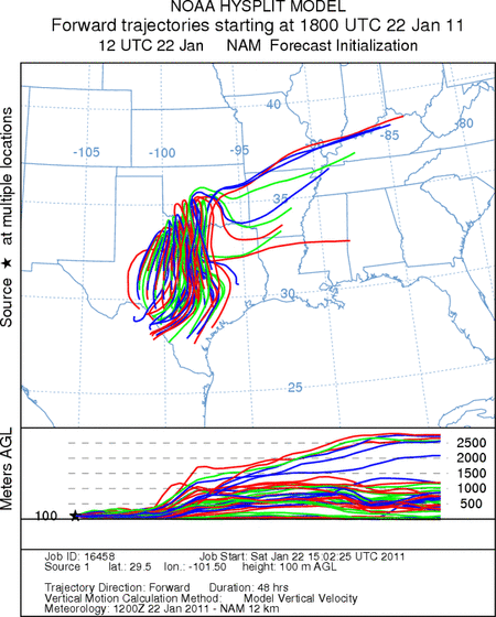
Trajectory weather: Air mass trajectories from the Edwards Plateau are very mixed today with winds beginning
from the west and southwest then switching to the south this afternoon and evening before returning to the southwest
late tonight and finally coming from the north tomorrow and tomorrow night. The eventual shift to a northerly
breeze will bring cold air into the region. Today sunny skies will prevail across the region with temperatures
in the low to mid-60s in most regions. Winds will begin at moderate levels from the west and southwest then become
more southerly towards the afternoon with stronger conditions. Tonight the skies will remain mostly clear with
more partly cloudy conditions towards the north. Temperatures will drop into the mid to upper 30s overnight.
Winds will continue from the south moving more back towards the southwest then tomorrow morning at some point a
northerly flow will take over at light to moderate levels. This mixing of wind directions will keep most of the
air moving in and around Texas for the next couple of days. Tomorrow night temperatures will drop into the 20s
and low 30s across the region with the return of cold conditions from the north.
OUTLOOK: *** High Threat today and High Threat Tomorrow*** very good conditions
for pollen release today and tomorrow. good conditions for entrainment today with good conditions tomorrow and
good conditions for transport exist today and tomorrow. Todays conditions will be driven by sunny skies and temperatures
in the 60s across the Edwards Plateau today. Temperatures tomorrow will cool under the influence of northerly
winds but still be warm enough to have some significant pollen release. The hallmark of the region will be swirling
winds with a number of wind direction changes as they begin from the south and southwest, move to the west, then
back to the south before switching to a northerly direction. Because of these conditions pollen entrained within
the air mass will be moving over the central Texas regions. Most of the trajectories remain within Texas, often
passing back over the release area. The trees are at their traditional peak of release and so pollination is expected
to occur in most areas where they grow. Warming conditions today and good conditions tomorrow coupled with concentrating
winds will result in high concentrations of juniper pollen in the atmosphere in most areas of central and western
Texas. Areas throughout the junipers distribution will experience pollen today with significant amounts tomorrow.
The wind trajectories show the overall pattern moving entrained pollen over the top of the Edwards Plateau into
southern Texas, therefore those areas can expect significant amounts of pollen in the atmosphere.
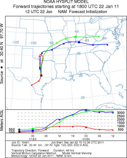
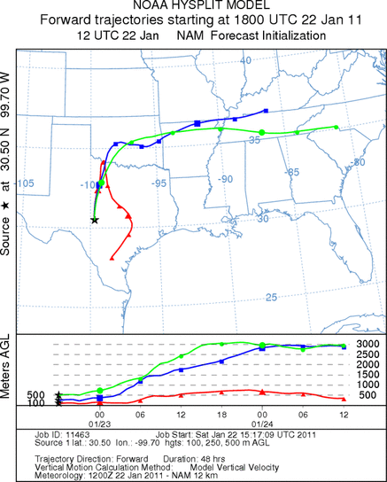
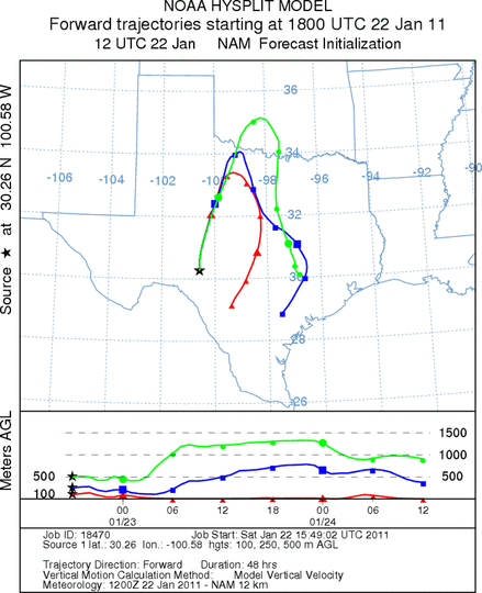
Trajectory Start (s) (shown by *
on map): Austin, TX; Junction, TX; Sonora, TX.
AUSTIN
JUNCTION
SONORA
EDWARDS PLATEAU COMPOSITE
Prepared by: Estelle
Levetin (Faculty of Biological
Science, The
University of Tulsa, 800 S. Tucker Dr., Tulsa, OK 74104) and ) and Peter
K Van de Water (Department of Earth and Environmental Science, California State University Fresno,
2576 East San Ramon Avenue, M/S ST24, Fresno CA 93740-8039). This forecast gives the anticipated future track of
released Mountain Cedar pollen, weather conditions over the region and along the forecast pathway, and an estimated
time of arrival for various metropolitan areas.
Questions: Aerobiology Lab e-mail: pollen@utulsa.edu
Return to Forecasting Home Page