The University of Tulsa
Mountain Cedar Pollen Forecast

Metropolitan Area |
Exposure Risk |
|
Oklahoma City |
Low |
|
Tulsa |
Low |
|
St. Louis MO |
Low |
Date Issued: 23 January 2011
Mountain Cedar Location(s): Arbuckle Mountains, OK
Regional Weather: Sunday, January 23 TX/OK:
Conditions across the region will be cool with temperatures ranging from the upper 20s in Oklahoma to the 50s
and 60s in Texas. Skies will be mostly cloudy during the next two days and winds will be moderate to strong.
In Oklahoma partly cloudy skies will occur today with temperatures in the mid- 40s along the Texas border and
much colder northward. Winds will be from the north at moderate levels. Tonight partly cloudy skies will occur
as low temperatures drop into the low 20s. Tomorrow high temperatures will warm some with temperatures from the
40s in Oklahoma to the 50s under partly cloudy skies. Tomorrow night low temperatures return to below freezing
conditions registering mid- to upper 20s with winds from the northeast at around 10 miles per hour. In Texas today,
mostly cloudy conditions will occur along the eastern edge of the Edwards Plateau. There is a 20% chance of showers
this afternoon. To the west, clear to partly cloudy skies and drier conditions will occur. Over the Plateau temperatures
will be in the mid to upper 50s and moderate to strong winds will occur coming from the north. Winds will be gaining
strength during the afternoon. Tonight mostly to partly cloudy skies with temperatures towards the west will be
in the mid- 20s. Towards the east mostly cloudy skies will occur with low temperatures in the thirties but above
freezing in most areas. Winds will continue from the north in all areas except for the northwest region around
San Angelo where a southerly breeze will begin to build. Tomorrow the western region of the Edwards Plateau will
see clearing with the skies becoming mostly sunny. Temperatures will be in the lower 60s and winds at light levels
from the south. Further east mostly cloudy skies will occur with temperatures in the 50s and the chance of showers
remaining. Winds will be from the northeast at light to moderate levels. Tomorrow night the chance of showers
will remain in the edge communities, temperatures will return to below freezing towards the west and 30s in the
east, and light to moderate winds from the north.
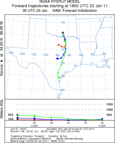
Trajectory weather: Air mass trajectories from the Arbuckle Mountains move south across central Texas
on moderate northerly winds. Today high temperatures will reach into the mid- 40s range under partly cloudy skies.
Conditions will be marginal to poor for pollen release. Tonight low temperatures will be in the lower- 20s with
light winds from the north. Tomorrow partly cloudy skies will prevail and winds will be light from the southeast
then turning back to the north overnight. The high temperature tomorrow will be in the low 50s with light and
variable winds to begin the day then switching to southeastern flow at moderate strength. Tomorrow night northeasterly
winds return at moderate conditions with temperatures in the upper 20s.
OUTLOOK: *** Low Threat today and Moderate Threat Tomorrow *** poor conditions for pollen release today
and moderate conditions tomorrow. poor conditions for entrainment and travel today, and poor conditions for tomorrow.
Partly cloudy skies will occur with high temperatures in the mid-40s today then tomorrow slight warming will occur
with high temperatures in the low 50s. Todays temperatures are not conducive for pollen release, it will cool
tonight then the temperature will rise for tomorrow. Moderate winds from the north today, tonight and tomorrow
night will drive anything in the atmosphere southward towards Texas. Tomorrow the winds will switch, coming from
the southeast for a portion of the day before switching back to a northerly direction. The atmosphere appears
heavy moving along the ground which tends to cleanse the atmosphere.
Trajectory Start (s) (shown by black
star on map): Davis, OK.
Prepared by: Estelle
Levetin
(Faculty
of Biological Science, The University of Tulsa, 800 S. Tucker Dr., Tulsa, OK 74104) and Peter
K Van de Water
(Department of Earth and Environmental Science, California State University Fresno, 2576 East San Ramon Avenue,
M/S ST24, Fresno CA 93740-8039). This forecast gives the anticipated future track of released Mountain Cedar pollen,
weather conditions over the region and along the forecast pathway, and an estimated time of arrival for various
metropolitan areas.
Questions: Aerobiology Lab e-mail: pollen@utulsa.edu
Return to Forecasting Home Page