
The University of Tulsa
Mountain Cedar Pollen Forecast
Metropolitan Area |
Exposure Risk |
|
Dallas/Fort Worth |
Low |
|
Austin |
Moderate to High |
|
San Antonio |
Moderate to High |
Date Issued: 23 January 2011
Mountain Cedar Location(s): Edwards Plateau, Texas
Regional Weather: Sunday, January 23 TX/OK:
Conditions across the region will be cool with temperatures ranging from the upper 20s in Oklahoma to the 50s
and 60s in Texas. Skies will be mostly cloudy during the next two days and winds will be moderate to strong.
In Oklahoma partly cloudy skies will occur today with temperatures in the mid- 40s along the Texas border and much
colder northward. Winds will be from the north at moderate levels. Tonight partly cloudy skies will occur as
low temperatures drop into the low 20s. Tomorrow high temperatures will warm some with temperatures from the 40s
in Oklahoma to the 50s under partly cloudy skies. Tomorrow night low temperatures return to below freezing conditions
registering mid- to upper 20s with winds from the northeast at around 10 miles per hour. In Texas today, mostly
cloudy conditions will occur along the eastern edge of the Edwards Plateau. There is a 20% chance of showers this
afternoon. To the west, clear to partly cloudy skies and drier conditions will occur. Over the Plateau temperatures
will be in the mid to upper 50s and moderate to strong winds will occur coming from the north. Winds will be gaining
strength during the afternoon. Tonight mostly to partly cloudy skies with temperatures towards the west will be
in the mid- 20s. Towards the east mostly cloudy skies will occur with low temperatures in the thirties but above
freezing in most areas. Winds will continue from the north in all areas except for the northwest region around
San Angelo where a southerly breeze will begin to build. Tomorrow the western region of the Edwards Plateau will
see clearing with the skies becoming mostly sunny. Temperatures will be in the lower 60s and winds at light levels
from the south. Further east mostly cloudy skies will occur with temperatures in the 50s and the chance of showers
remaining. Winds will be from the northeast at light to moderate levels. Tomorrow night the chance of showers
will remain in the edge communities, temperatures will return to below freezing towards the west and 30s in the
east, and light to moderate winds from the north.
Trajectory weather: Air mass trajectories from the Edwards Plateau are mixed today with partly cloudy skies
to the west and warmer conditions, highs in the 60s, compared to the eastern portion of the Edwards Plateau where
there is a chance of showers today, tonight, and tomorrow. In the east the high temperature today and tomorrow
will be in the mid- to upper- 50s. Today winds will be from the north at moderate to stronger levels this afternoon.
North of Austin towards northern Texas winds will be from the southwest, as winds wrap around the Plateau region.
Tonight low temperatures will be below freezing in the west and low 30s to the east. Winds will remain from the
north. Tomorrow, the 20% chance of rain showers is maintained in the edge communities, while sunny to mostly sunny
condition will dominate to the west. Temperatures will rise in most areas into the lower- 60s to the west. Those
areas will see the winds switch coming from the south. The remainder of the areas will see winds from the north.
Winds across the region will stay at low to moderate levels. Tomrrow night winds will return to a northerly flow
and temperatures will be below freezing west and in the 30s again along the eastern side of the Edwards Plateau
region.
OUTLOOK: *** Moderate to High Threat today and
tomorrow*** good conditions for pollen release today and tomorrow. moderate conditions for entrainment
today and tomorrow and good conditions for transport exist today and tomorrow. Todays conditions will be driven
by sunny skies to the east but humidity and the chance of showers across the western areas of the Edwards Plateau.
Temperatures in the 50s and 60s across the region today and tomorrow will be in the range where pollen is released
along with winds that will be moderate today but only light tomorrow. These are conditions that generally at this
time of year lead to really good conditions for pollen release, entrainment and travel. However, the forecast
calls for the potential of rain showers along the eastern side of the Edwards Plateau which indicates that humidity
will be high in those areas and mostly cloudy skies will reduce some of the capacity for pollen release and travel.
In addition, the region as a whole has had a number of days with high pollen levels and at some point the absolute
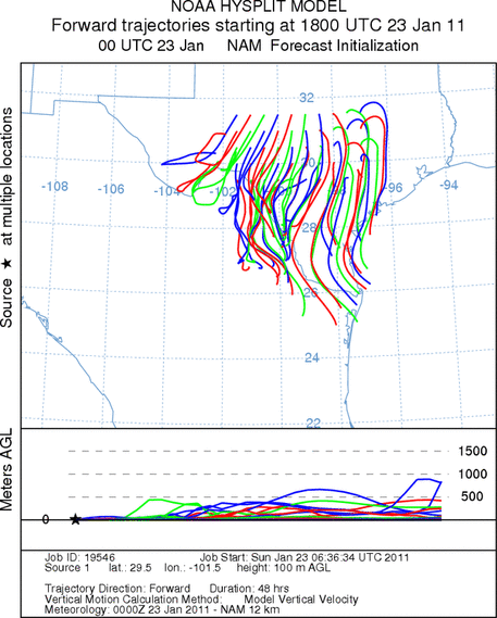
number of trees still waiting to initiate pollination will begin to diminish. All of the trajectories today will
push anything that does become entrained towards the south. Because of these conditions pollen entrained within
the air mass will be moving toward the southern Texas regions. Most of the trajectories remain within Texas.
The wind trajectories show the overall pattern moving entrained pollen over the top of the Edwards Plateau into
southern Texas, therefore those areas can expect pollen in the atmosphere.
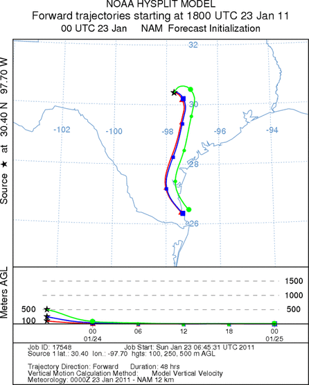
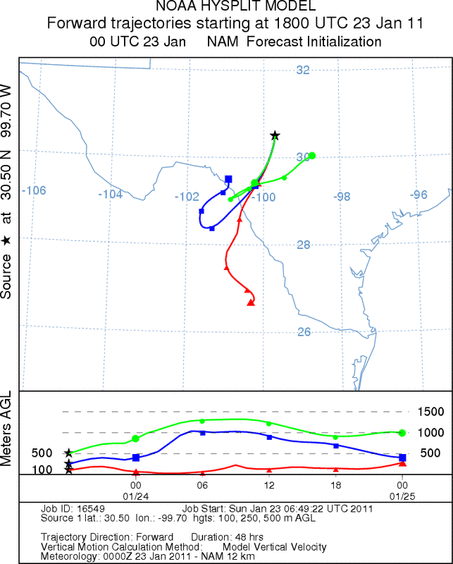
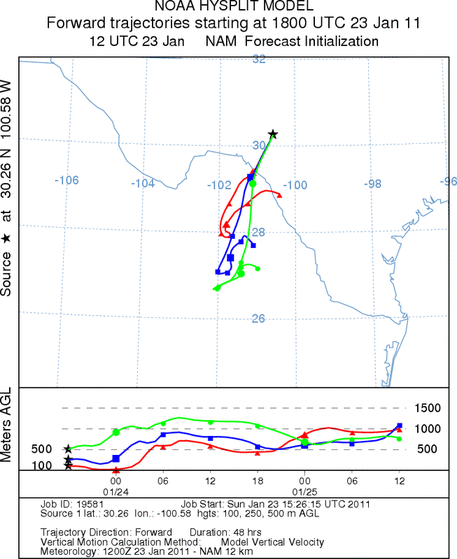
Trajectory Start (s) (shown by *
on map): Austin, TX; Junction, TX; Sonora, TX.
AUSTIN
JUNCTION
SONORA
EDWARDS PLATEAU COMPOSITE
Prepared by: Estelle
Levetin (Faculty of Biological
Science, The
University of Tulsa, 800 S. Tucker Dr., Tulsa, OK 74104) and ) and Peter
K Van de Water (Department of Earth and Environmental Science, California State University Fresno,
2576 East San Ramon Avenue, M/S ST24, Fresno CA 93740-8039). This forecast gives the anticipated future track of
released Mountain Cedar pollen, weather conditions over the region and along the forecast pathway, and an estimated
time of arrival for various metropolitan areas.
Questions: Aerobiology Lab e-mail: pollen@utulsa.edu
Return to Forecasting Home Page