
The University of Tulsa
Mountain Cedar Pollen Forecast
Metropolitan Area |
Exposure Risk |
|
Dallas/Fort Worth |
Moderate to High |
|
Austin |
Moderate to High |
|
San Antonio |
Moderate to High |
Date Issued: 24 January 2011
Mountain Cedar Location(s): Edwards Plateau, Texas
Regional Weather: Monday, January 24 TX/OK:
Conditions across the region will be mild today with temperatures todays in the 50s and 60s, and tomorrow cooling
into the 40s and 50s. Skies will be mostly cloudy during the next two days and winds will be moderate. In Oklahoma
partly cloudy skies will occur today with temperatures in the low- 50s along the border with Texas. Winds will
start this morning from the southeast but switch to a northerly and northeasterly direction. Winds will be light
throughout the day. Tonight partly to mostly cloudy skies will occur as low temperatures drop into the low 20s.
Tomorrow high temperatures will only warm into the mid- 40s under sunny skies. Winds will be light to moderate
from the north bringing cooler conditions with temperatures dropping by about 10 degrees. Tomorrow night low temperatures
return to mid- to upper 20s with winds from the southeast at modest levels becoming light and variable. In Texas
today, mostly cloudy conditions will occur across the eastern portions of the region, whereas the clouds will be
more broken to the west. There is a 20% chance of showers this afternoon and this evening in the edge communities
along the eastern side of the Edwards Plateau. Over the region temperatures will be in the upper 50s to the east
and low 60s to the west. Winds will be moderate from the northeast along the edge communities and moderate from
the south to southeast in the western areas of the Plateau. Tonight temperatures will be in the mid 20s to the
west and just above freezing along the eastern edge of the Edwards Plateau. Tomorrow skies will begin to clear
as northerly breezes at moderate levels move slightly cooler air across the region. High temperatures will be
in the lower to mid- 50s in most places and winds will be from the north and northwest. Mostly clear skies will
continue tomorrow night with temperatures falling below the freezing mark. Winds will once again be light to moderate
with a northerly flow maintained in the east but a southerly breeze to the west.
Trajectory weather: Air mass trajectories from the Edwards Plateau are mixed today with partly cloudy skies
to the west and warmer conditions, highs in the 60s, compared to the eastern portion of the Edwards Plateau where
there is a chance of showers today and tonight. In the east the high temperature today and tomorrow will be in
the mid- to upper- 50s. Today and tomorrow winds will be from the north at moderate levels. In western portions
of the region today and during the early portion of this evenings winds will be from the south at light to moderate
levels then switch to a more northerly direction. Will be in the mid- twenties to the west and mid-30s to the
east. Tomorrow, mostly sunny condition will dominate as the skies work to clear themselves. Temperatures will
drop a bit as the colder air from the north moves across the region. Temperatures will be in the mid to lower
50s in most places, the southern most areas may make it just to 60. Tomorrow night winds will return to the bimodal
pattern from the north in the eastern areas and from the south to the west. Temperatures will be below freezing
across the region.
OUTLOOK: *** Moderate to High Threat today and tomorrow***
good conditions for pollen release today and tomorrow. moderate conditions for entrainment today and tomorrow
and good conditions for transport exist today and tomorrow. Todays conditions will be driven by sunny skies to
the east but humidity and the chance of showers across the western areas of the Edwards Plateau. Temperatures
in the 50s and 60s across the region today and tomorrow will be in the range where pollen is released along with
winds that will be moderate today and tomorrow. These are conditions that generally at this time of year lead
to really good conditions for pollen release, entrainment and travel. However, the forecast calls for the potential
of rain showers along the eastern side of the Edwards Plateau which indicates that humidity will be high in those
areas and mostly cloudy skies will reduce some of the capacity for pollen release and travel. In addition, the
region as a whole has had a number of days with high pollen levels and at some point the absolute number of trees
still waiting to initiate pollination will begin to diminish. All of the trajectories today will push anything
that does become entrained towards the east at moderate levels. Most of the trajectories show them staying within
the Texas border. Because of these conditions pollen entrained within the air mass will be moving toward the eastern
Texas regions. As the northerly breezes mix more buoyant conditions will exist lifting pollen into the atmosphere
for downwind deposition. The wind trajectories show the overall pattern moving entrained pollen over the top of
the Edwards Plateau into eastern Texas, therefore those areas can expect pollen in the atmosphere.
Trajectory Start (s) (shown by *
on map): Austin, TX; Junction, TX; Sonora, TX.
AUSTIN
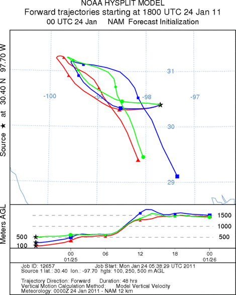
JUNCTION

SONORA
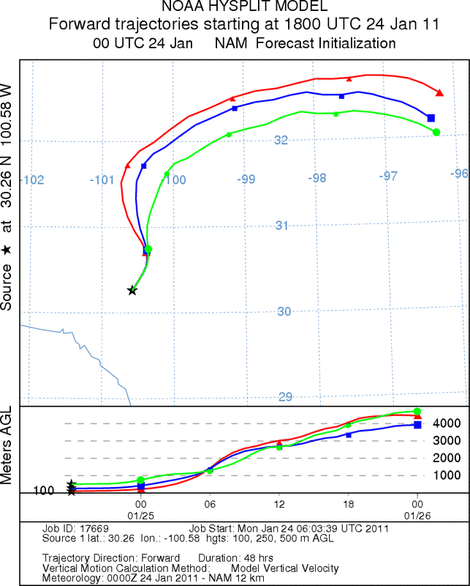
EDWARDS PLATEAU COMPOSITE
Prepared by: Estelle
Levetin (Faculty of Biological
Science, The
University of Tulsa, 800 S. Tucker Dr., Tulsa, OK 74104) and ) and Peter
K Van de Water (Department of Earth and Environmental Science, California State University Fresno,
2576 East San Ramon Avenue, M/S ST24, Fresno CA 93740-8039). This forecast gives the anticipated future track of
released Mountain Cedar pollen, weather conditions over the region and along the forecast pathway, and an estimated
time of arrival for various metropolitan areas.
Questions: Aerobiology Lab e-mail: pollen@utulsa.edu
Return to Forecasting Home Page