The University of Tulsa
Mountain Cedar Pollen Forecast

Metropolitan Area |
Exposure Risk |
|
Oklahoma City |
Low |
|
Tulsa |
Low |
|
St. Louis MO |
Low |
Date Issued: 26 January 2011
Mountain Cedar Location(s): Arbuckle Mountains, OK
Regional Weather: Wednesday, January 26 TX/OK:
Conditions across the region will be mild and warming today and tomorrow. Region highs today will be in the 50s
in most areas and in the 60s tomorrow. Tomorrow partly cloudy skies will remain but temperatures will continue
to warm into the low 60s. Winds will remain from the west at 10 miles per hour. Tonight partly cloudy skies will
remain with temperatures in the lower 20s under light and variable winds. Tomorrow night partly cloudy skies
are forecast and low temperatures will be warmer, in the low 30s. In Texas, mostly sunny to sunny skies will
rule the day. Temperatures will be in the mid 50s in most west and pushing into the low 60s to the east. Along
the eastern edge of the Edwards Plateau winds will start in most areas from the west or south. In San Antonio,
winds will start from the north. In the west most winds will be from the southeast at light conditions. The eastern
areas of the Plateau will also shift to the southeast late in the day. Tonight mostly clear conditions will occur
across the region. Low temperatures will be in the low 30s to the east and below freezing in the mid to lower
20s to the west. Tomorrow mostly sunny skies will return with temperatures warming some 10 to 15 degrees into
the mid to upper 60s. Winds will be from the northwest at moderate levels to the east, and from the west in the
west at light to moderate conditions. Tomorrow night will be mostly clear returning to below freezing conditions
in the west and in the low 30s to the east. Winds will switch from the earlier westerly direction to a more southwesterly
direction.
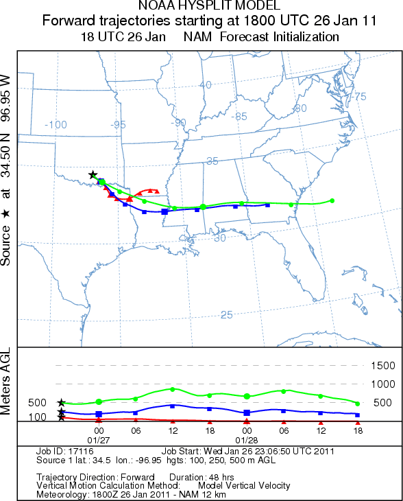
Trajectory weather: Air mass trajectories from the Arbuckle Mountains move south east on light winds that
will take it across southern Oklahoma and into Texas. Today high temperatures will reach the low 50s just reaching
into temperatures that are conducive to pollen release. The light winds and partly cloudy skies will lead to marginal
conditions for release. In addition the initial winds are dense and flowing at ground level. Eventually those
winds will encounter much more buoyant conditions but well beyond where pollen can maintain its entrainment in
the air mass. Tonight low temperatures will be in the lower- 20s with light and variable winds. Tomorrow sunny
skies will prevail and winds will be more moderate from the west during the day shifting to the southwest overnight.
The high temperature tomorrow will be near 60 with light to moderate winds from the west. Conditions tomorrow
will be much better for pollen release, entrainment and travel across the region. Tomorrow night southwest winds
will occur at moderate to light conditions with temperatures in the mid- 30s.
OUTLOOK: *** Moderate Threat today and High Threat Tomorrow
*** Moderate conditions for pollen release today and good conditions tomorrow. Moderate conditions for entrainment
and travel today, and good conditions tomorrow. Partly cloudy skies will occur with high temperatures in the upper
40s to low 50s today then tomorrow warming into the low 60s will bring much better conditions for pollen release.
Todays temperatures are suitable for pollen release, whereas tomorrow with temperatures in the low 60s conditions
will improve significantly. Overnight it will cool into the lower 20s and then tomorrow night it will be in the
lower 30s. Moderate winds will continue to push eastward on west winds across southern Oklahoma into areas to
the east. The air is begins dense and will flow along the ground increasing the impaction with vegetation and
other surfaces, a process that leads to reduced pollen concentrations. The forecast conditions of cold temperatures
and poor conditions for entrainment and travel make today to be a low threat. However warmer conditions tomorrow
should significantly increase the threat to the forecast value of a High Threat.
Trajectory Start (s) (shown by black
star on map): Davis, OK.
Prepared by: Estelle
Levetin
(Faculty
of Biological Science, The University of Tulsa, 800 S. Tucker Dr., Tulsa, OK 74104) and Peter
K Van de Water
(Department of Earth and Environmental Science, California State University Fresno, 2576 East San Ramon Avenue,
M/S ST24, Fresno CA 93740-8039). This forecast gives the anticipated future track of released Mountain Cedar pollen,
weather conditions over the region and along the forecast pathway, and an estimated time of arrival for various
metropolitan areas.
Questions: Aerobiology Lab e-mail: pollen@utulsa.edu
Return to Forecasting Home Page