
The University of Tulsa
Mountain Cedar Pollen Forecast
Metropolitan Area |
Exposure Risk |
|
Dallas/Fort Worth |
Low |
|
Austin |
Moderate to High |
|
San Antonio |
Moderate to High |
Date Issued: 26 January 2011
Mountain Cedar Location(s): Edwards Plateau, Texas
Regional Weather: Wednesday, January 26 TX/OK:
Conditions across the region will be mild and warming today and tomorrow. Region highs today will be in the 50s
in most areas and in the 60s tomorrow. Tomorrow partly cloudy skies will remain but temperatures will continue
to warm into the low 60s. Winds will remain from the west at 10 miles per hour. Tonight partly cloudy skies will
remain with temperatures in the lower 20s under light and variable winds. Tomorrow night partly cloudy skies
are forecast and low temperatures will be warmer, in the low 30s. In Texas, mostly sunny to sunny skies will
rule the day. Temperatures will be in the mid 50s in most of the west and pushing into the low 60s to the east.
Along the eastern edge of the Edwards Plateau winds will start in most areas from the west or south. In San Antonio,
winds will start from the north. In the west most winds will be from the southeast at light conditions. The eastern
areas of the Plateau will also shift to the southeast late in the day. Tonight mostly clear conditions will occur
across the region. Low temperatures will be in the low 30s to the east and below freezing in the mid to lower
20s to the west. Tomorrow mostly sunny skies will return with temperatures warming some 10 to 15 degrees into
the mid to upper 60s. Winds will be from the northwest at moderate levels to the east, and from the west in the
west at light to moderate conditions. Tomorrow night will be mostly clear returning to below freezing conditions
in the west and in the low 30s to the east. Winds will switch from the earlier westerly direction to a more southwesterly
direction.
Trajectory weather: Air mass trajectories from the central Texas region move southeastward on light winds
initially that will take them across the plateau towards southeastern Texas. However, winds will be very light
to moderate and thus the amount of movement will be somewhat limited. Areas to the northeastern portion of Texas
will see stronger winds that will begin to move into the region from the west, moving the trajectories towards
the east and into neighboring Louisiana over the forecast period. Today high temperatures will reach the mid 50s
to the west and the lower 60s to the east. These conditions are good for pollen release, but the light to moderate
winds will hamper entrainment and travel initially. In addition the winds are dense during the initial movement
meaning that any pollen that is entrained will move along the ground where impaction is greatest as a process to
cleanse particles from the atmosphere. However, just downwind more buoyant conditions occur lifting an remaining
pollen high into the atmosphere. The light winds and cool temperatures will lead to marginal conditions for release
today. Tonight low temperatures will be in the lower- 30s in the edge communities with moderate winds. Tomorrow
sunny skies will prevail and winds will be more moderate from the west to northwest during the day shifting to
the southwest overnight. The high temperature tomorrow will be in the 60s with light to moderate winds from the
west and northwest. Conditions tomorrow will be much better for pollen entrainment and travel across the region.
Tomorrow night southwest winds will occur at moderate to light conditions with temperatures in the mid- 30s
to the east and 20s to the west.
OUTLOOK: *** Moderate Threat today and High Threat Tomorrow***
good conditions for pollen release today and tomorrow. Poor conditions for entrainment exist today with good conditions
tomorrow. Poor conditions for transport exist today with good conditions tomorrow. Todays conditions will see
sunny skies over the Plateau and sunny skies in most of the other areas. Temperatures will be in the mid to upper
50s in most areas with the edge communities getting into the 60s. Winds will be in the light to moderate level
from the northwest in most areas. Pollen release is expected but not at severe levels with the cooler weather.
Conditions for entrainment and travel today will be poor to begin with, but very buoyant along the pathways to
the east. Pollen remaining entrained will be pushed towards the east into eastern Texas and Louisiana. For these
reasons the forecast is for moderate conditions. The region as a whole has had a number of days with high pollen
levels and at some point the absolute number of trees still waiting to initiate pollination will begin to diminish.
All of the trajectories today will push anything that does become entrained towards the northwest but on light
wind levels so the distance travelled will be modest. Most of the trajectories show them staying within the central
Texas region. Because of these conditions pollen entrained within the winds will remain centralized over Texas.
Tomorrow temperatures will warm into the 60s with an increase in winds from the west and northwest will present
a much greater chance of pollen release, entrainment and travel throughout the region. The wind trajectories
show the overall pattern moving entrained pollen over the Edwards Plateau eventually turning and pushing the winds
towards eastern Texas, therefore those areas can expect pollen in the atmosphere which may be heavy in localized
areas. Tomorrow presents much better conditions for pollination, entrainment and travel.
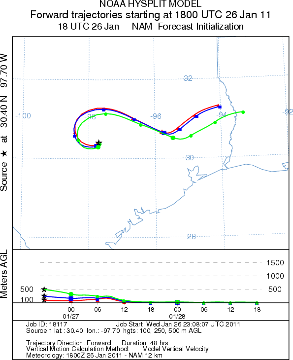
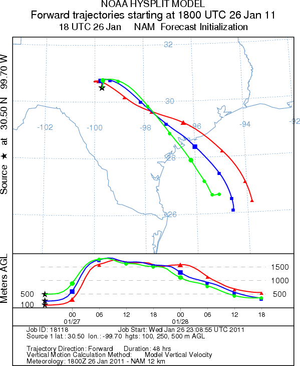
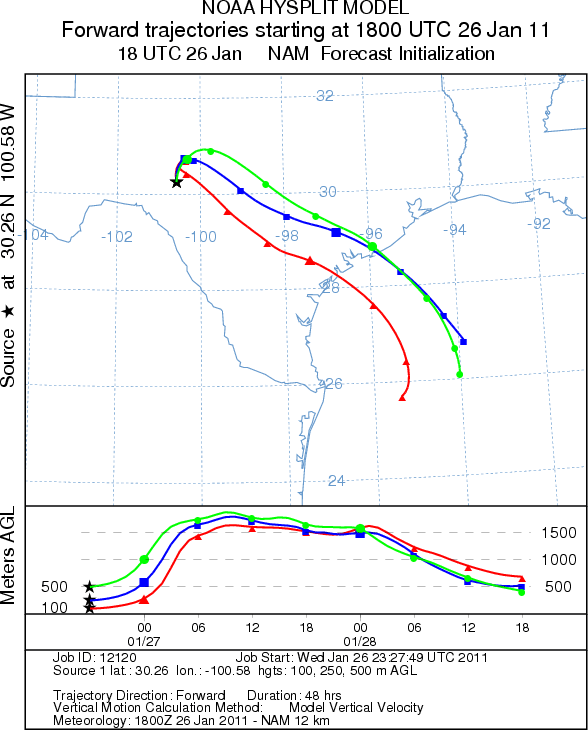
Trajectory Start (s) (shown by *
on map): Austin, TX; Junction, TX; Sonora, TX.
AUSTIN
JUNCTION
SONORA
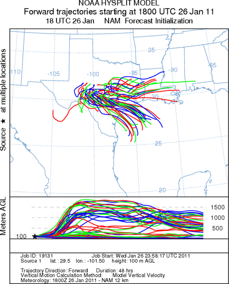
EDWARDS PLATEAU COMPOSITE
Prepared by: Estelle
Levetin (Faculty of Biological
Science, The
University of Tulsa, 800 S. Tucker Dr., Tulsa, OK 74104) and ) and Peter
K Van de Water (Department of Earth and Environmental Science, California State University Fresno,
2576 East San Ramon Avenue, M/S ST24, Fresno CA 93740-8039). This forecast gives the anticipated future track of
released Mountain Cedar pollen, weather conditions over the region and along the forecast pathway, and an estimated
time of arrival for various metropolitan areas.
Questions: Aerobiology Lab e-mail: pollen@utulsa.edu
Return to Forecasting Home Page