The University of Tulsa
Mountain Cedar Pollen Forecast

Metropolitan Area |
Exposure Risk |
|
Oklahoma City |
Low |
|
Tulsa |
Low |
|
St. Louis MO |
Low |
Date Issued: 28 January 2011
Mountain Cedar Location(s): Arbuckle Mountains, OK
Regional Weather: Friday, January 28 TX/OK:
Conditions across the region will be mild with warm temperatures in the upper 60s to low 70s today and tomorrow.
Winds will be light to moderate from the southwest today, tonight and switching to a more southerly direction
tonight and tomorrow. Tomorrow night winds will move back to a southwesterly flow at low to moderate levels.
In Oklahoma sunny skies with temperatures in the upper 60s and low 70s will occur with low temperatures in the
low to mid 30s overnight. Winds will be from the southwest at light to moderate levels today and tonight. Light
and variable wind conditions are expected across the region where the junipers grow. Tomorrow temperatures will
be in the low 70s for the highs with southerly winds up to 10 miles per hour under partly cloudy skies. Tomorrow
night skies will become mostly cloudy with temperatures cooling to the upper twenties towards the north and low
30s around the Texas border region. Winds will remain light but from the southeast and there is a 20% chance
of showers occurring with stormier conditions moving through Texas. In Texas, sunny skies will occur across the
region today with the beginning of cloud build up to the west this afternoon and into tonight. Temperatures will
be warming into the upper 60s and low 70s. Winds will be from the southwest across the region at moderate levels
building to slightly stronger levels to the west late in the afternoon. At the same time clouds will begin to
build as a system begins to move into the area. Tonight, those partly cloudy skies will build to mostly cloudy
conditions. Temperatures will be warm with lows int the upper 30s to mid 40s. Winds to the west will switch
to a southerly direction with the remaining area under a more southwesterly flow. Wind strength will remain moderate
to light. Tomorrow cloudy conditions on the eastern side of the Edwards Plateau will bring a 50% chance of rain
showers to the edge communities. To the west the chance of showers will build to a 20% to 30% chance. High temperatures
will remain in the low 70s to upper 60s and winds will remain at a moderate level from the south. The chance
of rain increases tomorrow night with a 60% to 70% chance of showers overnight in the edge communities. To the
west the 20% to 30% chance of rain is maintained. Temperatures overnight will remain very warm with lows expected
in the 40s and 50s across the region. Winds will return to a predominant southwesterly direction at light to
moderate levels.
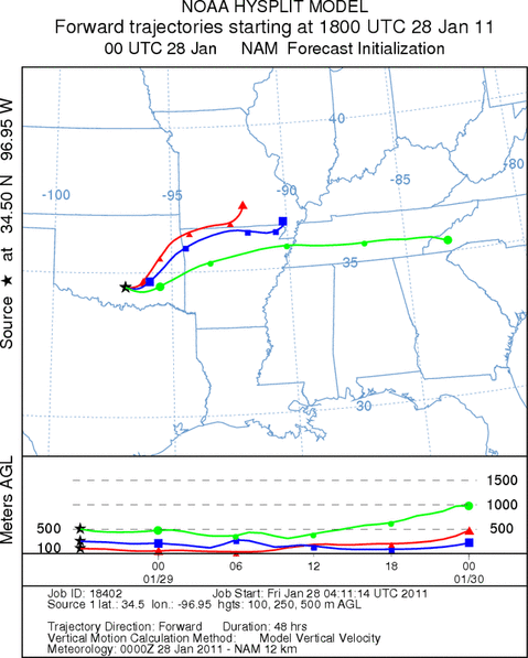
Trajectory weather: Air mass trajectories from the Arbuckle Mountains move east to northeast on light to
moderate winds that travel across the ground today that will take them across southeastern Oklahoma and into northern
Arkansas. Temperatures today will be warm today with the areas where the junipers grow expected to be in the upper
60s to low 70s under sunny skies. Entrained pollen will move at or near ground level, however, with dense air
across the area. Tonight winds will become light and maintain a southerly flow, temperatrures are expected to
be in the mid to lower 30s. Tomorrow warm temperatures will once again be in store for southern and central Oklahoma
with highs in the 70 degree range. Winds will be from the south at slightly stronger conditions and but todays
sunny skies will degrade to partly cloudy conditions as a weather system moves across the Texas region. Tomorrow
night mostly cloudy skies with seasonal overnight temperatures (upper 20s to low 30s) will occur but with mostly
cloudy skies and a 20% chance of showers.
OUTLOOK: *** Moderate Threat today and Moderate Threat Tomorrow *** good conditions
for pollen release today and tomorrow with warm temperatures in the area. However, there will be poor conditions
for entrainment and travel today, and tomorrow as well. Sunny skies will occur with high temperatures in the upper
60s today and lower 70s tomorrow and provide very good conditions for pollination to occur at the tree sites.
Winds today will be from the southwest at light to moderate conditions with the atmosphere stable and dense across
the area. Overnight it will cool into the mid- 30s with light and variable wind conditions. Light to moderate
winds will continue to push any entrained pollen northeastward but light winds and a dense atmosphere will make
entrainment and travel sub-optimal. The forecast conditions of warm temperatures and good conditions for pollination
but poor conditions for entrainment and travel results in todays forecast only being moderate, and the chance of
pollen will drop-off significantly at increasing distance from the trees.
Trajectory Start (s) (shown by black
star on map): Davis, OK.
Prepared by: Estelle
Levetin
(Faculty
of Biological Science, The University of Tulsa, 800 S. Tucker Dr., Tulsa, OK 74104) and Peter
K Van de Water
(Department of Earth and Environmental Science, California State University Fresno, 2576 East San Ramon Avenue,
M/S ST24, Fresno CA 93740-8039). This forecast gives the anticipated future track of released Mountain Cedar pollen,
weather conditions over the region and along the forecast pathway, and an estimated time of arrival for various
metropolitan areas.
Questions: Aerobiology Lab e-mail: pollen@utulsa.edu
Return to Forecasting Home Page