The University of Tulsa
Mountain Cedar Pollen Forecast

Metropolitan Area |
Exposure Risk |
|
Oklahoma City |
Moderate |
|
Tulsa |
Moderate |
|
St. Louis MO |
Low |
Date Issued: 29 January 2011
Mountain Cedar Location(s): Arbuckle Mountains, OK
Regional Weather: Saturday, January 29 TX/OK:
Conditions across the region will be mild with warm temperatures in the upper 60s to mid- 70s today. Winds will
be moderate from the south today, and then tonight areas to the south will have winds from the southwest and in
the north from the southeast. Tomorrow, winds will be from the north in the north, from the southwest along the
eastern edges of the Edwards Plateau and from the northwest in areas of western Texas. Today and tonight there
is a significant chance of showers in many areas of Texas and southern Oklahoma. In Oklahoma clear to partly cloudy
skies will occur today with high temperatures in the lower 70s with low temperatures tonight in the low 30s to
the north and the upper 30s along the border with Texas. Winds will be from the south at moderate levels today
and diminishing to light conditions tonight shifting around to northerly winds after midnight. Overnight there
is a 20% chance of showers in the region. Tomorrow temperatures will cool with highs expected in the lower 40s
to just at 50 degrees. Skies will be partly to mostly cloudy with showers southward in Texas in the morning.
Winds will have shifted coming from the north at light to moderate strength. Tomorrow night cloudy skies with
the chance of drizzle will occur, temperatures will be in the low 30s and winds will be light and variable. In
Texas today, cloudy skies will build during the day with an increasing chance of rain towards the afternoon. Temperatures
will remain warm in the 60s to low 70s. The western regions will see a slight chance of precipitation today and
tonight. Over the Edwards Plateau the chance will build towards the eastern edge communities where there is a
50% chance of precipitation today increasing to a 60% to 70% tonight. Low temperatures will be in the 40s to 50s
in the eastern edge communities falling to the lower 40s and upper 30s to the west. Winds will be from the south
today at moderate levels. Tonight winds will shift coming from the southwest. Tomorrow the chance of precipitation
declines with remnants of the system moving through the central and northern areas of the Edwards Plateau. Into
the afternoon conditions will be clearing. Temperatures will remain in the 60s and 70s with winds from the southwest
over the eastern Edward Plateau area, but from the northwest in the western regions. Tomorrow night partly cloudy
to mostly cloudy conditions will occur with temperatures relatively warm with no area expected to be below freezing.
Winds will be light and shifting over the area.
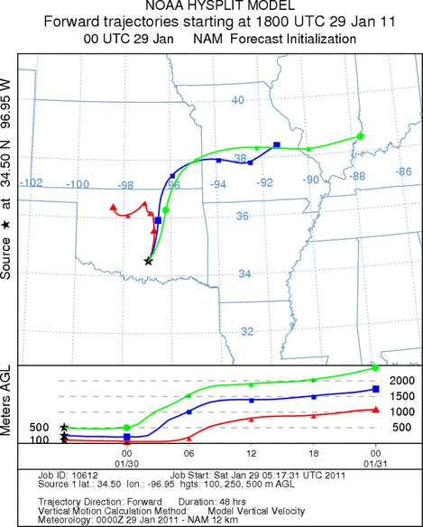
Trajectory weather: Air mass trajectories from the Arbuckle Mountains move north, northeast towards central
Oklahoma at ground level eventually traveling towards the west, while at higher elevations the winds will continue
north and eastward. The winds begin heavy traveling at the elevation that they begin at for some time before becoming
incorporated, at upper elevations, into more buoyant conditions. The lowest elevation winds remain within Oklahoma
whereas the upper elevation winds move off to the northeast. Tonight the winds will shift from todays southerly
direction coming out of the southeast. With this change a 20% chance of showers and drizzle will occur over the
area where the trees are growing. Temperatures today will be warm in the area where the junipers grow. Conditions
are expected to reach into the low 70s under partly cloudy skies. Tomorrow a north wind takes over at moderate
levels and temperatures drop into the 40s. In the region that borders Texas temperatures are expected to barely
get to 50 degrees.
OUTLOOK: *** Moderate Threat today and Low Threat Tomorrow
*** good conditions for pollen release today but poor conditions tomorrow with warm temperatures in the area
today then cooling significantly tomorrow. Moderate conditions for entrainment for both days but poor conditions
for travel today and tomorrow. Warm conditions today will be very good for pollen cones to open and shed their
pollen. That shed pollen may become entrained into the atmosphere with the moderate winds from the south that
will be blowing through the region. However, surface winds today are stable to slightly heavy and any entrained
pollen will move through the vegetation as it travels. In cases where this happens impaction on objects becomes
a significant cleanser of the atmosphere with distance. Tonight the chance of showers over the region increases
and the winds eventually turn towards a northerly flow for tomorrow. In addition the north winds will cool the
region significantly. The forecast conditions of warm temperatures with moderate winds will result in good conditions
for pollination as well as conditions for entrainment. However, travel will be suboptimal resulting in todays
forecast of only moderate conditions, and the chance of pollen will drop-off significantly at increasing distance
from the trees. Tomorrow the significant drop in temperature should retard pollination from the tree population.
Trajectory Start (s) (shown by black
star on map): Davis, OK.
Prepared by: Estelle
Levetin
(Faculty
of Biological Science, The University of Tulsa, 800 S. Tucker Dr., Tulsa, OK 74104) and Peter
K Van de Water
(Department of Earth and Environmental Science, California State University Fresno, 2576 East San Ramon Avenue,
M/S ST24, Fresno CA 93740-8039). This forecast gives the anticipated future track of released Mountain Cedar pollen,
weather conditions over the region and along the forecast pathway, and an estimated time of arrival for various
metropolitan areas.
Questions: Aerobiology Lab e-mail: pollen@utulsa.edu
Return to Forecasting Home Page