The University of Tulsa
Mountain Cedar Pollen Forecast

Metropolitan Area |
Exposure Risk |
|
Oklahoma City |
Low |
|
Tulsa |
Low |
|
St. Louis MO |
Low |
Date Issued: 30 January 2011
Mountain Cedar Location(s): Arbuckle Mountains, OK
Regional Weather: Sunday, January 30 TX/OK:
Conditions across the region will be mild with temperatures cooling off today reaching only from the mid 30s to
mid 40s to the north, but temperatures well above seasonal norms to the south across Texas. In Oklahoma, skies
will be partly cloudy to mostly cloudy as north winds bring colder conditions at moderate winds strength. Tonight
there is a chance of drizzle under cloudy to mostly cloudy skies across the area as temperatures stay in the mid
to upper 30s. Winds will become light and variable. Tomorrow the chance of drizzle remains with cloudy conditions
across the area. Winds will remain light and variable. Tomorrow night, however a strong system begins to move
into the region with winds ramping up with moderate to strong winds from the north. Temperatures will drop into
the teens and twenties and there will be a chance of snow to the north and freezing rain across the area along
the border with Texas. In Texas today, the skies will vary between partly cloudy to begin with then becoming sunny
or starting sunny then becoming partly cloudy. As the day begins there was a chance of showers along the eastern
edge of the Edwards Plateau but most of the day will be clear and mostly sunny. Temperatures today and tomorrow
will be above seasonal norms with a lot of 70 degrees plus being recorded. Winds will be moderate with an east
to west split. Those in the eastern area will be from the southwest whereas those in the western areas will see
winds from the northwest. The lite to moderate wind conditions will remain until tomorrow afternoon when a significant
change in the weather begins to push into the area. Tonight the region will have partly to mostly cloudy conditions
with warm conditions overnight. The eastern edge communities will be in the upper 40s to lower 50s for low temperatures.
In the east 30s and 40s are expected. Winds will be light and mixed across the area. Tomorrow morning there
is a chance of fog along the eastern edge, but temperatures will warm quickly into the 70s across the whole region.
Winds will begin to ramp up in strength as the system nears to the north. Winds will be from the southeast along
the eastern side of the Edwards Plateau and from the south to southwest from the central Edwards Plateau towards
the west. Tomorrow night mostly cloudy skies and a significant chance of showers across the region occurs. Temperatures
will continue to be 50s across much of the eastern Edwards Plateau, and 30s to 40s in the west. Winds will be
from the south at strong levels. In the west winds begin to turn to a direction from the northwest late at night
accompanied by very strong gusty conditions.
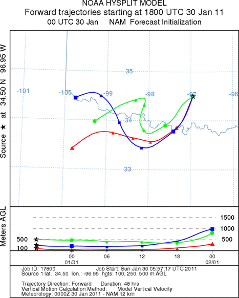
Trajectory weather: Air mass trajectories from the Arbuckle Mountains move south to southwest towards northern
Texas at ground level on light winds. The winds begin dense travelling at the elevation that they begin at for
the forecast period. The winds from southern Oklahoma will move slowly and remain relatively close to their origin
in northernmost Texas Tonight and tomorrow the winds remain light and variable, until weather changes tomorrow
night bringing strong winds from the north pushing cold air southward across Texas. Tonight and tomorrow morning
there is a chance of drizzle throughout the region. Tomorrow temperatures will return to the low 50s and upper
40s then tomorrow night cold conditions take over with the chance of snow and freezing rain. Surface temperatures
will be in the upper teens to mid 20s with northeasterly winds from 10 to 20 miles an hour.
OUTLOOK: *** Low Threat Today and Low Threat Tomorrow *** poor conditions for
pollen release today and tomorrow with cold temperatures in the area today then an increasing chance of precipitation
tonight and tomorrow. There will be poor conditions for entrainment and travel both today and tomorrow. Cold
conditions today will be poor for pollen cones to open and shed their pollen. In addition poor conditions will
occur for shed pollen to become entrained into the atmosphere with lite to moderate winds today easing to light
and variable winds tonight and tomorrow. Surface winds today will be stable to slightly heavy, with any pollen
that has become entrained moving through the vegetation as it travels. In cases where this happens impaction on
objects becomes a significant cleanser of the atmosphere with distance. Tonight the chance of drizzle over the
region increases with lite and variable winds. The chance of drizzle remains tomorrow with an almost duplicate
of temperatures as today, although the winds remain lite and variable. A significant change in weather will occur
tomorrow night with a significant chance of snow and light freezing rain across the region. Winds tomorrow night
will become strong and gusty as todays mild conditions are overtaken by a significant weather system moving through
the region.
Trajectory Start (s) (shown by black
star on map): Davis, OK.
Prepared by: Estelle
Levetin
(Faculty
of Biological Science, The University of Tulsa, 800 S. Tucker Dr., Tulsa, OK 74104) and Peter
K Van de Water
(Department of Earth and Environmental Science, California State University Fresno, 2576 East San Ramon Avenue,
M/S ST24, Fresno CA 93740-8039). This forecast gives the anticipated future track of released Mountain Cedar pollen,
weather conditions over the region and along the forecast pathway, and an estimated time of arrival for various
metropolitan areas.
Questions: Aerobiology Lab e-mail: pollen@utulsa.edu
Return to Forecasting Home Page