
The University of Tulsa
Mountain Cedar Pollen Forecast
Metropolitan Area |
Exposure Risk |
|
Dallas/Fort Worth |
Moderate |
|
Austin |
Moderate |
|
San Antonio |
Moderate |
Date Issued: 31 January 2011
Mountain Cedar Location(s): Edwards Plateau, Texas
Regional Weather: Monday, January 31 TX/OK:
Conditions across the region will be similar to yesterday for the beginning of the day. However, in the afternoon
and into the evening conditions begin to change drastically. In Oklahoma, partly cloudy to mostly cloudy skies
will be over the area with the chance of drizzle this afternoon. Temperatures will be in the upper 30s to near
50 today with higher humidity. Winds will be variable. This afternoon and tonight conditions begin to degrade
as a major weather system starts to work into the region. In Oklahoma there will be a chance of snow and freezing
rain overnight. Temperatures will be in the teens to upper 20s from the central state area towards the border
region. Winds will have begun to gain strength during the afternoon and will reach strong levels overnight, coming
from the north at ten to twenty miles per hour. Tomorrow temperatures will stay below freezing with snow in the
forecast. Winds will continue from the north at strong levels. Tomorrow night temperatures will be close to single
digits with a decreasing chance of precipitation, but winds will remain strong but shift, coming from the northwest.
In Texas, conditions today will continue to be warm with temperatures in most areas maintaining their 70 degree
marks. However, during the afternoon and into the evening conditions will begin to change with a significant shift
in temperatures and increase in precipitation as cold air moves over the region. Along the eastern edge of the
Edwards Plateau winds will be from the southeast developing to strong levels towards evening, whereas to the west
winds will be from the southwest, also gaining strength at the end of the day. Tonight a significant chance of
precipitation develops across the Plateau and in its surrounding communities; Temperatures overnight will fall
into the lower 50s and upper 40s in most regions. Winds will continue to be strong with gusts in and around the
edge communities in the 30 mile per hour range. Tomorrow will be cold with high temperatures just reaching 50
in the furthest southern communities. Frozen precipitation is expected in most communities as the chance of precipitation
will remain in the forecast. Winds will be from the north and be strong. Tomorrow night strong winds from the
north to northwest will bring temperatures down into the low twenties and teens across the region. Wind chills
will be significantly lower.
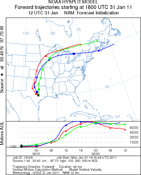
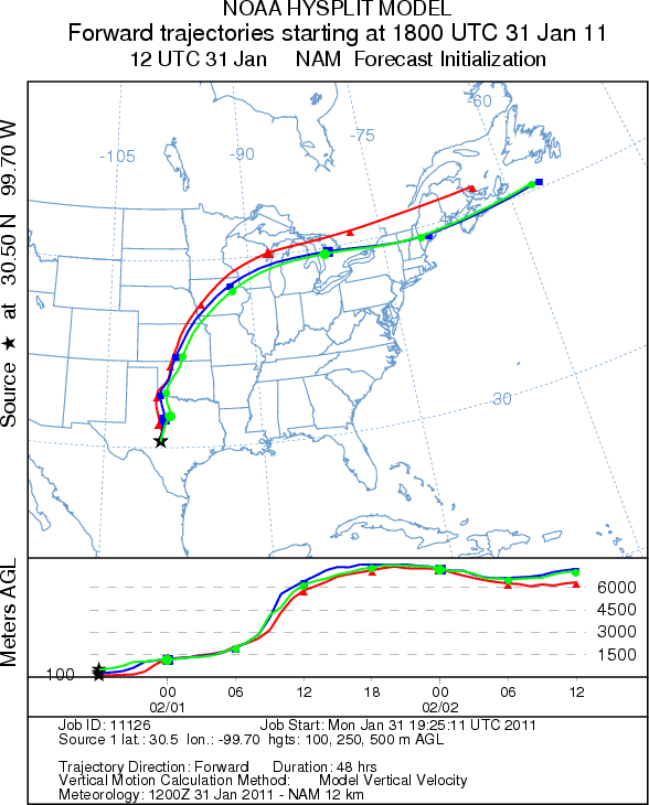
Trajectory weather: Air mass trajectories from the Edwards Plateau move north on southerly winds towards
the western and central Oklahoma and on toward the northeast. Initial light winds will move the air but high winds
are expected in the afternoon and will drive the atmosphere northward at a quickened pace. The air is dense during
the first portion of the travel then begins to interact with more buoyant conditions as it meets and moves above
the oncoming weather front. Any pollen that is entrained has the potential to travel long distances. Temperatures
across the source area are warm today but get colder tomorrow and tomorrow night, with conditions becoming life
threatening with the wind chills factored in. Be careful.
OUTLOOK: *** Moderate Threat Today and Low Threat Tomorrow**** Good conditions for pollen release today
and good conditions for transport. Significant amounts of pollen may be released in Texas today and carried to
the north. Tomorrow, the cold front and storm system will eliminate the potential for any pollen release or transport.
Trajectory Start (s) (shown by *
on map): Austin, TX; Junction, TX; Sonora, TX.
AUSTIN
JUNCTION
SONORA
Prepared by: Estelle
Levetin (Faculty of Biological
Science, The
University of Tulsa, 800 S. Tucker Dr., Tulsa, OK 74104) and ) and Peter
K Van de Water (Department of Earth and Environmental Science, California State University Fresno,
2576 East San Ramon Avenue, M/S ST24, Fresno CA 93740-8039). This forecast gives the anticipated future track of
released Mountain Cedar pollen, weather conditions over the region and along the forecast pathway, and an estimated
time of arrival for various metropolitan areas.
Questions: Aerobiology Lab e-mail: pollen@utulsa.edu
Return to Forecasting Home Page