The University of Tulsa
Mountain Cedar Pollen Forecast

Metropolitan Area |
Exposure Risk |
|
Oklahoma City |
Low |
|
Tulsa |
Low |
|
St. Louis MO |
Low |
Date Issued: 4 January 2012
Mountain Cedar Location(s): Arbuckle Mountains, OK
Regional Weather: Wednesday, January 4 TX/OK:
The region will have partly cloudy skies to the north in Oklahoma and over the Edwards Plateau today. Regions
in north Texas and along the edge of the Edwards Plateau will be sunny today. Temperatures will remain in the
upper 50s and low 60s over the area. Winds will be light to moderate primarily from the north. The strongest
winds will occur along the western side of the Edwards Plateau where sustained wind conditions will be upwards
of 20 miles per hour. Tonight the northern regions in Oklahoma and northern Texas will be clear with overnight
lows reaching the mid 30s to low 40s. To the south partly cloudy skies will dominate the surrounding edge communities
with low temperatures in the 40s and the Edwards Plateau in the upper 20s. Winds will be light and variable
to the north. Over the rest of the region winds will be light to moderate from the north. Tomorrow morning, sunny
skies will return with a few clouds over the edge communities. Temperatures will warm by a few degrees with most
areas in the mid to upper 60s. Winds to the north will switch coming from the southwest, whereas north to northwesterly
winds will occur over the Edwards Plateau region. Those areas will experience light to moderate wind conditions.
Going into the evening winds will once again shift across Texas, coming from the southwest at light to moderate
levels. As that shift occurs, more moisture will be pulled into the area and partly cloudy skies will return to
the lower elevation areas, especially in the edge communities surrounding the Edwards Plateau. On the Plateau
itself, mostly clear skies will remain. Temperatures will be in the lower 40s surrounding the Plateau and at
or just below freezing over the Plateau. There continues to be a lack of precipitation, and no significant rain
storms are expected in the next few days.
Trajectory weather: Air mass trajectories from southern Oklahoma move due south on northerly breezes today
on light winds over the forecasting period. Tonight light and variable winds will take over. Partly cloudy skies
are expected today with clear conditions tonight, todays temperatures are expected to reach the high 50s to low
60s. Along the pathway towards the south similar conditions will exist. Tonight skies will clear and temperatures
will dip into the mid 30s. Tomorrow sunny skies and temperatures into the mid 60s are forecast. Winds will
shift during the morning hours, coming from the southwest at light to moderate levels. Tomorrow night the area
will be in the mid to upper 30s with clear skies and light winds from the south, becoming more variable.
OUTLOOK: *** Moderate to Low Threat today and Moderate Threat Tomorrow *** Good conditions for pollen release
today and tomorrow with Moderate conditions today and tomorrow for entrainment and transport. Clear skies today
with temperatures in the upper 50s and low 60s will provide good conditions for pollination. However, winds
will be at light to moderate levels from the north today, relaxing to light and variable conditions overnight.
Therefore, entrainment and travel conditions will be moderate to low. Tomorrow winds will be switching back to
a southerly flow at moderate levels, thus pollen entrainment will be better although in the border region where
the tree population occurs, only 10 mile per hour winds are forecast. Temperatures will be in the low 60s today
with low temperatures in the mid 30s tonight. Tomorrow temperatures will climb into the upper 60s across the
border region with light to moderate southwesterly winds. Only moderate conditions exist for pollination today
and tomorrow. We continue to look for a clear signal of pollen dispersal from the southern Oklahoma population.
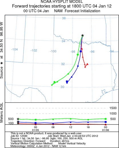
Trajectory Start (s) (shown by black
star on map): Davis, OK.
Prepared by: Estelle
Levetin
(Faculty
of Biological Science, The University of Tulsa, 800 S. Tucker Dr., Tulsa, OK 74104) and Peter
K Van de Water
(Department of Earth and Environmental Science, California State University Fresno, 2576 East San Ramon Avenue,
M/S ST24, Fresno CA 93740-8039). This forecast gives the anticipated future track of released Mountain Cedar pollen,
weather conditions over the region and along the forecast pathway, and an estimated time of arrival for various
metropolitan areas.
Questions: Aerobiology Lab e-mail: pollen@utulsa.edu
Return to Forecasting Home Page